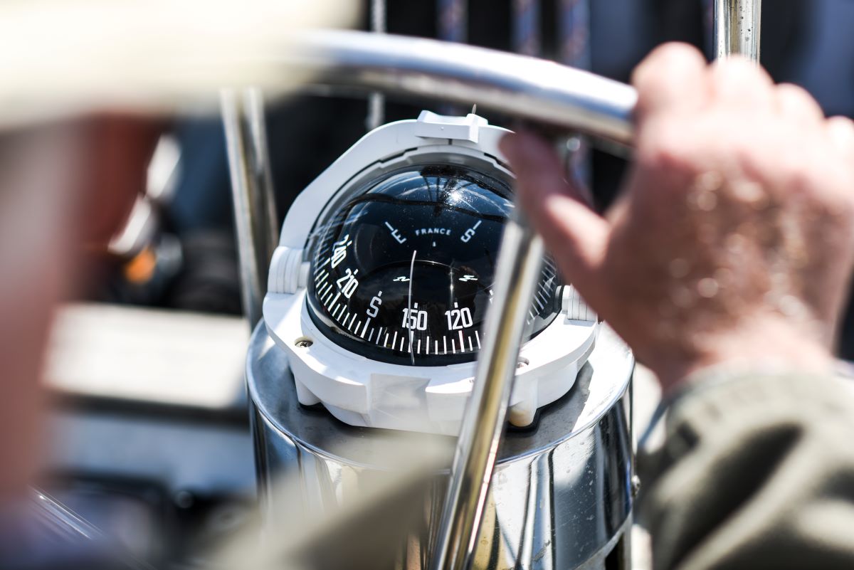
A boat compass is a boat's basic navigation
instrument, showing the vessel's heading using the earth's magnetic field. It's
the only navigation instrument on a boat that works without electricity and is
fully self-contained – alongside GPS devices and a chartplotter, it's an
essential backup and safety instrument in every condition. In Finnish waters,
where electronic equipment can fail due to moisture or interference, a reliable
magnetic heading is every boater's most important navigation tool.
Its operation is based on a simple physical
principle: magnetized needles or cards align with the earth's magnetic field
and point north. Unlike GPS-based navigation devices, it needs no satellite
connection, batteries, or external power source. This makes it a reliable tool
even in challenging conditions, such as fog, storms, or a power outage.
How a boat compass works and its construction
Operation relies on the earth's magnetic
field. In a traditional liquid-filled compass, a magnetized needle or card
floats in a light fluid (usually mineral oil or an alcohol mixture), which
dampens the swinging caused by the boat's motion and keeps the reading stable
even in waves. The card is marked with cardinal directions (N, E, S, W) and
degrees (0–360°), and it rotates freely with the magnetized needle toward
magnetic north.
The compass dome's job is to protect the card
and fluid from sunlight, moisture, and mechanical shocks. Most quality models
also have built-in lighting for navigating in the dark. Compensating screws
allow calibration – correcting for deviation.
Although GPS-based navigation devices have
quickly become common in boating, a traditional compass retains its place as a
critical safety instrument. Electronics can fail for many reasons – a dead
battery, moisture damage, or satellite signal interference – and in such
situations a well-calibrated compass is the only reliable navigation
instrument. The ability to navigate using a compass and nautical chart is part
of every boater's basic skill set.
Compass types for boats
Models suited to boating can be divided into
three main types based on mounting method and intended use:
Surface-mounted models are the most common
choice on small and medium-sized motorboats, since they're easy to install and
don't require cutting holes in the helm console or deck. Flush-mounted
versions, meanwhile, are more popular on sailboats, where the helm position
typically has an open deck and good visibility is critical.
Bulkhead models are especially useful on long
passages where navigation happens partly below deck. These units are visible
from both sides of the bulkhead and give the navigator an accurate heading
without needing to go on deck.
Magnetic variation and deviation – interpreting readings
A boat compass doesn't point directly toward
true north, but toward magnetic north, which differs from true north depending
on location. Two key factors affect this: magnetic variation and deviation.
Magnetic variation
Magnetic variation is the difference between
the earth's true north and magnetic north. Variation varies by geographic
location and changes slowly over time as the earth's magnetic field shifts.
In Finland, magnetic variation is currently
about +6° to +11° east. In practice, this means about 6–11 degrees needs to be
added to the displayed magnetic heading to get the true heading on the chart.
For example, if the reading shows 090° (east), the true heading is about
096°–101°.
Magnetic variation is marked on every nautical
chart via the compass rose, and it must always be accounted for when plotting
routes from the chart for navigation. Modern GPS chartplotters account for
magnetic variation automatically, but when using a traditional compass, the
boater must calculate the correction themselves.
Deviation (compass error)
Deviation is the error a boat's own metal,
electronics, and magnetic components cause in the reading. When a boat is built
from steel or aluminum, or when it has an engine, fuel tank, or wiring nearby,
these affect the magnetic field and cause deviation.
Deviation varies
with the boat's heading. Unlike magnetic variation, which is a fixed geographic
value, deviation is unique to each boat and depends on how the boat is built
and which direction it's pointing. For example, a boat's compass might read
correctly heading north, but show 5° too far east on an easterly heading and 3°
too far west on a westerly heading.
To correct for
deviation, the compass must be calibrated, after which a deviation table is
drawn up showing the error for each heading. The table is mounted near the
instrument or the boat's helm so the navigator can correct the reading as
needed.
Correct placement on the boat –
where does it work best?
Location on the
boat significantly affects accuracy. Poor placement can cause large deviation,
making the instrument almost useless for navigation.
The ideal mounting location
The instrument
should be located somewhere that is:
Easy to read from
the helm – It must be within the helmsman's line of sight without needing to
turn their head or look away from the route for long.
As far as
possible from metal structures – The engine, fuel tank, wiring, and radios can
cause significant deviation.
As far as
possible from electronic equipment – Chartplotters, VHF radios, fishfinders,
and especially tall speakers can interfere with operation. A minimum distance
of 30–50 cm from electronics is recommended.
On a stable mount
– It must be securely fastened so it stays steady even in waves and doesn't
point incorrectly due to the boat's motion.
Protected from
direct sunlight and rain – Although the instrument is water-resistant,
prolonged exposure to direct sunlight and heat can damage the dome and fluid.
On sailboats, the
instrument is often placed in front of the helmsman's position, either
flush-mounted in the deck or surface-mounted. On motorboats, it's typically
mounted on the helm console at a point directly at or slightly below the
driver's eye level.
Avoiding sources of interference
The following
devices and materials can cause deviation and should be kept at a distance:
Electric motors
and generators
VHF radios and
AIS transmitters
Fishfinders and
their transducers
Phones and
tablets with magnetic mounts
Tall speakers and
amplifiers
Metal tools and
equipment nearby
Fuel tanks and
engine parts
If the boat's
construction or equipment layout doesn't allow an ideal mounting location,
deviation can be compensated for through calibration. However, calibration
doesn't remove all interference, so optimizing placement should always be the
primary goal.
Calibration and creating a
deviation table
Calibration is
the process of measuring and correcting, as far as possible, the deviation
caused by the boat. It's worth calibrating whenever the instrument is installed
on a new boat, the boat's structure is significantly modified, or readings seem
inaccurate.
The calibration process, step by
step
1. Preparation
for calibration
Choose a calm,
windless day and an open area of water with no other traffic. You'll also need
an external reference – this can be a second, accurate heading source, a GPS
device, or a known landmark whose exact bearing is known from the chart.
2. Turn the boat
to different headings
Steer the boat
slowly and steadily toward the main cardinal and intercardinal directions (N,
NE, E, SE, S, SW, W, NW) – eight directions in total. At each heading, stop the
boat briefly and let the instrument settle. Record the reading and compare it
to the true heading (from GPS or a known landmark).
3. Create a
deviation table
Record the
differences between the displayed and true headings. For example:
4. Correct
deviation using the compensating screws
Most models have
compensating screws that can correct part of the deviation. Adjustments should
be made slowly and carefully, since even small changes significantly affect
readings. It's worth leaving adjustment of the compensating screws to a
professional if you lack experience.
5. Post the
deviation table where it's visible
The deviation
table drawn up after calibration is mounted near the instrument or the helm.
The table is used as a navigation aid: when you want to travel in a specific
direction, the deviation is added to or subtracted from the reading.
When should calibration be
redone?
Recalibration
should be done if:
New electronics
are installed nearby on the boat
The boat's
structure is modified (e.g., a new engine or metal equipment)
The instrument is
replaced or moved to a different location
The boat is used
in a different geographic area with a different magnetic variation
The reading
appears clearly inaccurate compared with GPS or sea marks
Navigating with a compass –
basic principles and practical tips
This instrument
isn't just a backup alongside GPS – it's a self-contained navigation tool that
can be used to safely cover even long distances. Basic navigation skills with a
compass and nautical chart are the foundation of every boater's safety.
Setting a heading
When you want to
navigate in a specific direction, the first step is to determine the direction
from the chart. This is done by measuring the direction on the chart with
dividers and measuring the angle against the compass rose. The direction
measured from the chart is the true direction, which must be converted to a
magnetic heading by accounting for magnetic variation and deviation.
Example: You want
to sail from one island to another. You measure a direction of 090° (true east)
from the chart. On the Finnish coast, magnetic variation is +8° east, so we
subtract this: 090° - 8° = 082° (magnetic heading). If the deviation table shows that deviation at
heading 082° is -3°, we adjust for this: 082° + 3° = 085°. You should therefore
steer to a heading of 085° on the instrument.
Use in fog and poor visibility
Fog is one of the
most difficult navigation situations, since landmarks aren't visible and a GPS
chartplotter doesn't tell you what's nearby. A magnetic heading is an
irreplaceable tool in these conditions.
When navigating
in fog, it's important to:
Hold a tight
heading – Even the smallest deviations grow into significant errors over long
distances.
Use speed and
time to estimate distance – If the boat's speed is 10 knots, in ten minutes
you'll cover 1.7 nautical miles (about 3 km). This lets you estimate when the
next landmark or island should come into view.
Use sound signals
– Fog signals, such as bells, buoys, or lighthouses, can help with positioning.
Stay calm and
trust the instrument – The instrument is reliable if it's correctly calibrated.
Don't guess or rely on a "feeling" in fog.
Combining with GPS navigation
In modern
navigation, a traditional compass heading and a GPS chartplotter complement
each other. A GPS chartplotter shows exact position, route, and depth data, but
it doesn't work without power or a satellite connection. A magnetic compass, on
the other hand, always works, but it doesn't show your position on a chart.
The best way to
use both is to plan your route in advance with the chartplotter, record the
headings and distances to each turn point, and navigate by these. If the GPS
fails, you can safely continue your trip using the traditional compass and
recorded data. This "hybrid navigation" combines the convenience of
modern technology with the reliability of traditional navigation.
Maintenance and upkeep
The instrument is
mechanically simple, but it requires regular maintenance to work correctly. A carefully cared-for boat compass can
work reliably for decades.
Regular inspection and cleaning
The dome should
be cleaned regularly with a soft, damp cloth. Don't use solvents or harsh
cleaning agents, which can damage the plastic or markings. At the same time,
check that the dome has no cracks or leaks. If there are air bubbles in the
fluid, they can affect accuracy, and the instrument should be serviced or
replaced.
Checking the fluid
Most models are
filled with mineral oil, an alcohol mixture, or glycol. The fluid dampens the
card's swinging and keeps the needle steady. If air bubbles are visible in the
dome, it can be a sign of a leak or that temperature swings have caused the
fluid to expand.
Small air bubbles
usually don't significantly affect operation, but if a bubble is large (over 5
mm in diameter), the instrument should be serviced. Refilling the fluid
requires special tools, so it's best left to a professional.
Winter storage
If the boat is
hauled out for winter, the instrument can either be left in place or removed
and stored indoors. If left on the boat, make sure it's protected from direct
sunlight and that the boat's interior stays relatively dry. Excess moisture can
cause condensation inside the dome.
If the instrument
is removed, store it at room temperature and avoid sharp temperature swings.
Don't store it in the immediate vicinity of metal objects or electronics, since
they can affect its magnetization.
Choosing a boat compass – what
should you consider?
When choosing,
it's important to consider the boat's size, type, and navigation needs. A small
recreational boater needs a different model than a sailor making long offshore
passages.
Size and readability
The card's
diameter affects how easily readings can be read. Smaller models (50–70 mm) suit small motorboats
and are economical, but can be hard to read in bright sunlight or poor
visibility. Larger
models (85–100 mm or more) are clearer and easier to read, but take up more
space on the helm console.
Mounting method
Choose
the mounting method based on the boat's construction and helm space:
Surface-mounted
– Easy to install, doesn't require recessing. Suits small boats and motorboats.
Flush-mounted –
Neat appearance, protected from impacts. Requires a hole cut in the console and
professional installation.
Bulkhead model –
Readable from inside and out. Suits sailboats and long passages.
Lighting and night visibility
If you boat in
the dark, the instrument needs working illumination. Most modern models use LED
lights, which draw little power and last a long time. Make sure the lighting is
adjustable so overly bright light doesn't dazzle you at night.
Material and durability
Quality boat
compasses are made of UV-resistant plastic or glass, and their mounting
mechanisms are designed to withstand the boat's vibration and shocks. Don't
choose cheap consumer-electronics compasses for a boat – they generally don't
withstand marine conditions and don't give accurate readings.
Summary: the most reliable
navigation instrument
A boat compass is
a simple but irreplaceable navigation instrument that works without electricity
or a satellite connection in all conditions. Correct placement, calibration,
and mastering how to use it are basics every boater should know.
While modern GPS
chartplotters and navigation devices offer accurate positioning and easy route
planning, a traditional magnetic compass is the only tool that always works.
GPS can fail due to a dead battery, moisture, or satellite interference, but a
well-calibrated compass shows direction for as long as it's in working order.
Mastering this
skill together with chart-reading ability is the foundation of a boater's
safety. In the Finnish archipelago, where fog, narrow channels, and complex
routes can challenge navigation, this instrument is every boater's best friend.
Sources and further reading
Traficom –
Boating safety and navigation rules
Suomen Purjehdus
ja Veneily ry (Finnish Sailing and Boating Federation) – Navigation training
and boating courses
Väylävirasto
(Finnish Transport Infrastructure Agency) – Maritime information and nautical
charts
Silva – Compass manufacturer, user manuals and
technical data
Plastimo – A leading boat compass
manufacturer, installation instructions
|
Type |
Intended use |
Advantages |
Challenges |
||
|
Surface-mounted |
Smaller boats, motorboats, sailboats |
Easy to install, no recessing needed, can be
mounted directly on deck or console |
More exposed to impacts, requires a flat
mounting surface |
||
|
Flush-mounted |
Sailboats, larger motorboats, cruisers |
Neat appearance, protected from impacts,
integrates into the console or deck helm |
Requires a hole in the console or deck,
needs professional installation |
||
|
Bulkhead model |
Sailboats,
below-deck navigation table |
Readable from inside, practical on long
passages, doesn't take up deck space |
Limited
visibility from the helm, mainly suited to route planning |
||
|
Displayed heading |
True heading (GPS) |
Deviation |
|||
|
000° (N) |
002° |
+2° (east) |
|||
|
045° (NE) |
047° |
+2° |
|||
|
090° (E) |
085° |
-5° (west) |
|||
|
135° (SE) |
132° |
-3° |
|||
Disclaimer
This guide provides general guidance only and does not replace the product manufacturer's operating, installation, or service instructions. Marinekauppa is not responsible for actions taken based on this guide or their consequences. Always check product-specific instructions and consult a qualified professional if needed.


