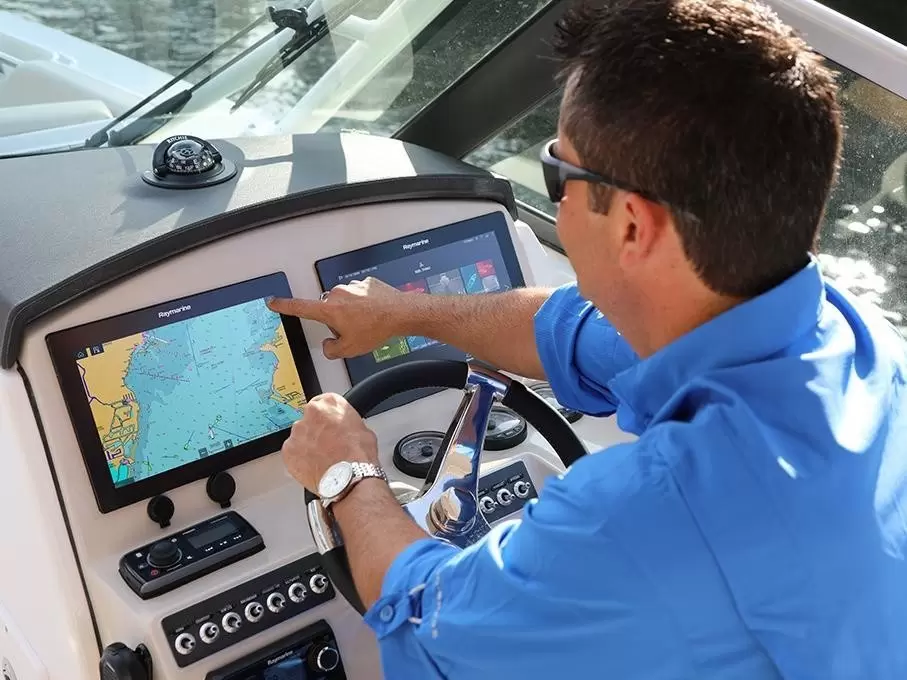
A chartplotter is a boat navigation device
that combines GPS positioning with an electronic nautical chart and shows the
vessel's position in real time on a screen. The device enables safe navigation
by showing the boat's exact position, its track, and the direction to your
destination. It differs from a plain GPS unit in that the position data is
displayed on a chart background showing channels, depth data, harbors, and
other features critical to navigation. In Finland's fragmented archipelago, an
electronic navigation device is a near-essential safety item for many boaters,
making getting around safer and more comfortable in every season.
How does a chartplotter work in practice?
The device's
operation is based on GPS satellite positioning and electronic charts. A
built-in GPS receiver picks up signals from multiple satellites and uses them
to calculate the boat's exact position. This position data is combined with
nautical chart data stored on the chart card, so the vessel's position is drawn
on the chart on the screen in real time.
Modern devices
typically update position data 10 times per second, enabling accurate
navigation even at higher speeds. GPS accuracy is typically about 3–5 meters in
normal conditions, and with WAAS/EGNOS correction it can reach 1–2 meters. In
the Finnish archipelago, this level of accuracy is sufficient for safe
navigation along channels and into harbors.
Devices need a
separate chart card containing the nautical chart data needed for navigation.
The most popular chart options are Navionics, C-MAP, and Garmin BlueChart.
Chart card choice depends on the brand of navigation device you use, since, for
example, Garmin generally uses its own charts, while Raymarine, Lowrance,
Simrad, and B&G are compatible with Navionics and C-MAP charts.
Installing a
chart card is simple: the card is inserted into the device's memory card slot,
after which the navigation device reads the chart data automatically. Most modern models use microSD cards, and
older devices may have a standard SD card slot.
Basic chartplotter features and
functions
Every
chartplotter includes certain basic features that make navigation safe and
convenient. The screen shows the boat's position, course over ground (COG),
speed over ground (SOG), and track. The device also shows distance and
direction to selected route and turn points, plus an estimated time of arrival
(ETA).
Route planning is
one of the most central functions. A boater can plan a route in advance by
marking turn points on the chart, and the device guides toward the next point
by providing clear navigation data. As the boat approaches a turn point, the
navigation device signals with an audio alert and automatically switches to
guiding toward the next leg. More advanced models include automatic route
planning (Auto Routing), which accounts for the boat's draft and overhead
clearances and makes use of official boating channels.
A typical
chartplotter includes the following features:
• GPS positioning
and track recording (Track)
• Creating and
managing waypoints and routes
• Displaying
depth data and channel markings on the chart
• Harbor
information and service search function
• Instrument
functions: speed, heading, distance, and time
• Anchor alarm
and MOB (Man Overboard) function
AIS vessel
traffic display is an add-on that's especially useful in busy waters and poor
visibility. With an AIS receiver, nearby vessels, their heading, and speed are
drawn on the screen, significantly improving situational awareness.
A multifunction display expands
what you can do
Many modern
chartplotters are multifunction displays (MFDs), where navigation functions can
be combined with the boat's other systems. The NMEA 2000 network protocol
allows different devices to be connected to the same system, so a single screen
can control the chart, fishfinder, autopilot, engine data, and even the
entertainment system.
A popular
combination is a chartplotter and fishfinder in the same unit. The screen can
then be split so that, for example, the nautical chart shows on the left and
the sonar picture on the right. This is especially useful for anglers who want
to track both their position on the chart and the underwater world at the same
time. Raymarine, Garmin, Lowrance, and Simrad all offer a wide range of combo
units for different uses and budgets.
Networking also
opens up the possibility of controlling the autopilot directly from the
navigation device's screen. Once the device and autopilot are connected to the
same network, you can activate a route and let the autopilot steer the boat
automatically from one turn point to the next. This frees your hands for other
tasks and makes long passages more comfortable.
For most people,
the plotter is the boat's most important electronic device and the heart of the
whole system, so it's worth taking the time to choose it carefully.
"Chartplotter" is somewhat of a misleading term nowadays, since most
plotters on the market are actually multifunction displays that can be
connected to all kinds of functions.
Chartplotter or smartphone –
which suits boating?
Mobile apps such
as Navionics Boating, Loisto, and Savvy Navvy have brought electronic
navigation within reach of every boater via smartphone. Phone apps are
affordable, easy to use, and always on hand – but they have clear limitations
compared with a fixed navigation device.
The biggest
advantage of a fixed navigation device is reliability. These devices are built
to withstand sea spray, direct sunlight, temperature swings, and continuous use
season after season. Screen brightness is typically 2–3 times better than on a
regular smartphone, making it easy to read even in bright sunshine and with
polarized sunglasses.
Another major
advantage is that a fixed navigation device draws power from the boat's
electrical system. A phone's battery can run out at a critical moment, while a
chartplotter works as long as the boat has power. In addition, the phone is
often needed for other things too – emergency calls and staying in touch – so
reserving it solely for navigation isn't always practical.
Phone apps work
well as a backup navigation system or for occasional day boating in familiar
waters. For longer trips, unfamiliar waters, and more serious boating, a fixed
navigation device is clearly the safer and more practical choice.
A phone is a good
backup navigation system, but it doesn't replace a fixed chartplotter. Screen
brightness, water resistance, and the ability to network with other devices
make it superior, especially on long passages and in unfamiliar waters.
How do I choose the right
chartplotter for my boat?
The most
important criteria when choosing a navigation device are screen size, intended
use, expandability, and budget. When thinking about screen size, keep in mind
that too small a device makes reading the chart difficult, especially in
sunshine, but too large a screen can be in the way in a cramped helm or block
visibility.
When choosing
screen size, the following recommendations can help:
• 5–7 inches:
Small boats, jet skis, dinghy sailing, backup navigator
• 9 inches: The
most common choice for day boats and fishing boats – a good compromise between
size and usability
• 12–16 inches:
Larger motorboats, sailboats, and professional use
Intended use
significantly affects model choice. Anglers benefit from a combo unit with both
navigation functions and a fishfinder – this lets you see both your position on
the chart and the underwater world on the same screen. Sailors, meanwhile,
appreciate models that display sailing data, such as B&G devices with
built-in wind angle, VMG, and other data important for sailing. For cruising
boaters, good chart support and the ability to connect an autopilot to the
system matter most.
Networking is an
important feature if you're planning to expand the system later. An NMEA
2000-compatible device allows an autopilot, VHF radio, wind instruments, radar,
and other devices to be connected to the same network. Stand-alone devices, on
the other hand, suit those who want a simple, affordable basic solution.
Tips for beginners
It's worth
starting to use a new chartplotter by getting to know it calmly at home or at
the dock before heading out on the water. Most navigation devices have built-in
tutorials, quick guides, and simulator modes that let you learn the basic
functions quickly without the boat needing to be moving.
Here are the six
most important tips for a beginner user:
1. Mark your home
harbor and important places as waypoints. Once your frequently used locations
are saved, navigating between them is quick and easy. You can also group
waypoints into folders, for example "Home waters," "Fishing
spots," or "Places to visit."
2. Always record
your track. The Track function automatically saves your route to the device's
memory. The track lets you safely retrace your route if visibility drops due to
fog or darkness.
3. Check your
chart's update status regularly. Navionics and other chart manufacturers
continually update their charts, and an up-to-date chart is the foundation of
safety. Channels, harbors, and depth data can change over the years.
4. Don't blindly
trust automatic routing. Automatic route planning is a useful aid, but you
should always check the final route yourself. In Finland's rocky waters, the
algorithm doesn't always account for every special feature.
5. Keep a paper
chart and compass on board. Electronics can fail unexpectedly, for example due
to a lightning strike or an electrical fault. A paper chart and compass are
still important equipment on every boat.
6. Practice
emergency functions in advance. It's worth practicing the MOB (Man Overboard)
function before you actually need it. Most devices have a
quick MOB button that immediately records the position.
Maintenance and updates
A chartplotter requires little maintenance,
but regular upkeep extends the device's lifespan and ensures reliable
operation. Wipe the screen with a soft microfiber cloth and fresh water after
every outing, especially in salt water. Don't use alcohol-based cleaners, as
they can damage the screen coating.
Chart updates should be done at least once a
year before the boating season starts. Most chart manufacturers offer an annual
update entitlement that includes the latest channel changes, depth data, and
harbor information. Navionics charts can be updated with the Chart Installer
program on a computer or via the ActiveCaptain app on a mobile device.
Software updates
are also worth keeping current. Manufacturers regularly release updates that
improve performance, fix software bugs, and add new features. Update
instructions are available on the manufacturer's website or in the device's
manual.
Frequently asked questions about
chartplotters
Does a chartplotter need an
internet connection to work?
No. The device
works entirely independently, without a network connection, using GPS
satellites and the chart card installed in the device. An internet connection
is only useful for chart updates and weather services.
What's the difference between a
chartplotter and a fishfinder?
A chartplotter
shows the boat's position on a nautical chart using GPS, while a fishfinder
uses reflected sound waves to show what's under the boat. Many combo units
include both functions in the same device.
Can the device be used without a
chart card?
Technically yes,
but the practical benefit is negligible. Without a chart card, the device only
shows the boat's position on a blank background, with no nautical chart data
available. Some devices include a built-in basic map, but it's usually too
coarse for precise navigation.
How long does a chartplotter
last in use?
Quality devices
typically last 8–15 years. Electronics aging and the end of chart update
support are usually the reasons a device gets replaced before it actually
breaks.
How much does a chartplotter
cost?
A simple device
costs around €300–500. Mid-range combo units with a
fishfinder cost €600–1,500, and top-tier models can exceed €3,000. In addition, a chart card typically costs
€100–250.
Which brand is the best?
There's no single
"best" brand – the choice depends on intended use and preference.
Garmin is known for ease of use, Lowrance and Simrad are popular among anglers,
B&G is the sailor's choice, and Raymarine offers versatile options for
every use.
Chartplotters from Marinekauppa
A chartplotter is
today's boater's most important navigation device, combining GPS positioning
with an electronic nautical chart. It significantly improves navigational safety and comfort, especially in
Finland's rocky waters. While phone apps offer an affordable option for
occasional use, a fixed navigation device is superior in reliability, screen
quality, and expandability on long passages and in demanding conditions.
In Marinekauppa's
extensive range you'll find chartplotters from leading manufacturers:
Raymarine, Garmin, Lowrance, Simrad, B&G, and Humminbird. The range
includes both stand-alone navigation devices and combo units with a built-in
fishfinder. Remember to get a suitable chart card covering the waters you need
– for Finnish sea areas, the most popular choice is Navionics EU644L!
Sources
GPS.gov – Official GPS system information and
technical specifications
Navionics – Electronic nautical chart
manufacturer
Raymarine – Marine electronics manufacturer
|
Feature |
Chartplotter |
Smartphone/tablet |
|
Screen brightness in sunlight |
Excellent (800–1,600 nits) |
Weak–moderate (400–800 nits) |
|
Water resistance |
IPX6/IPX7 –
built for marine use |
Needs a
separate protective case |
|
GPS accuracy and update rate |
Very accurate, 10 Hz update |
Good, typically 1–5 Hz |
|
Power source |
Boat's 12V system |
Battery, needs charging |
|
Expandability |
Fishfinder,
autopilot, AIS, radar, cameras |
Limited – separate apps |
|
Screen size |
Typically 7–16 inches |
5–12 inches (tablet) |
|
Lifespan |
8–15 years |
3–5 years |
|
Price |
€300–5,000 + chart card |
€0–150 (app + chart license) |
Disclaimer
This guide provides general guidance only and does not replace the product manufacturer's operating, installation, or service instructions. Marinekauppa is not responsible for actions taken based on this guide or their consequences. Always check product-specific instructions and consult a qualified professional if needed.