Navionics Charts
You can find Navionics chart cards in Marinekauppa’s extensive selection.Navionics Charts -ryhmän tuotteet
By far the most popular chart card for devices from Lowrance, Simrad, Raymarine and Humminbird, among others. The chart card is supplied in an SD adapter, which contains a smaller microSD card.
Navionics chart data can be accessed in advance for free in the Navionics WebApp service.
Always ensure that the map card is compatible with your device before ordering.
ATTENTION FOR LOWRANCE DEVICES! Works with Lowrance Elite HDI and Elite CHIRP series and all HDS series devices. Not compatible with older Lowrance devices that cannot use 16Gb memory cards.
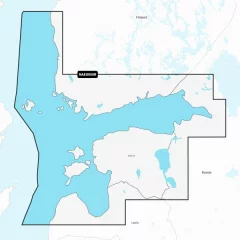
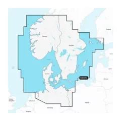
- Navionics Finnish sea area MSD/EU050R
- Sea areas: Gulf of Finland and Riga
- MicroSD card (16GB, SD adapter included)
- All Navionics charts also include small boat lanes
- 12 months of free updates. Requires registration of the chart card in the Navionics online service within 2 months of chart purchase.
By far the most popular chart card for devices from Lowrance, Simrad, Raymarine and Humminbird, among others. The chart card is supplied in an SD adapter, which contains a smaller microSD card.
Navionics chart data can be accessed in advance for free in the Navionics WebApp service.
Always ensure that the map card is compatible with your device before ordering.
ATTENTION TO LOWRANCE EQUIPMENT! Works with Lowrance Elite HDI and Elite CHIRP series and all HDS series devices. Not compatible with older Lowrance devices that cannot use 16Gb memory cards.
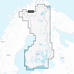
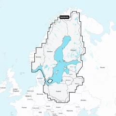
- Navionics Finnish Inland Waters MSD/EU055R
- Finnish lakes: All the largest lakes and bodies of water and numerous smaller lakes
- MicroSD card (16GB, SD adapter included)
- All Navionics charts also include small boat lanes
- 12 months of free updates. Requires registration of the chart card in the Navionics online service within 2 months of chart purchase.
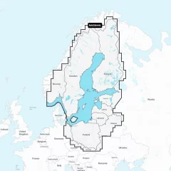
The new EU644L is by far the most popular chart card for chartplotters and combination devices. The EU644L has replaced the old 44XG chart card. It is compatible with Lowrance, Raymarine, Simrad, B&G and Hummingbird devices. The chart card is supplied in an SD adapter, which contains a smaller microSD card. MicroSD card (32GB, SD adapter included)
Navionics chart data can be accessed in advance for free in the Navionics WebApp service.
Always ensure that the map card is compatible with your device before ordering.
Coverage
- Sea areas: Entire Baltic Sea
- Finnish lakes: All the largest lakes and bodies of water and numerous smaller lakes
- Swedish lakes: Vänern and Vättern and other smaller lakes
- All Navionics charts also include small boat lanes
- 12 months of free updates. Requires registration of the chart card in the Navionics online service within 2 months of chart purchase. Requires registration of the chart card in the Navionics online service within 2 months of chart purchase.
NOTE! Not compatible with older devices that cannot use a 32Gb memory card. A 1GB or 2GB card is available for these devices.
- MicroSD card (32GB, SD adapter included)
- 12 months of free updates.
- Covers the Baltic Sea and Finnish lakes
With SD/MicroSD card. Detailed coverage of the Skagerrak and Kattegat and their inlets.
The map card includes
From Kristiansund on the Scandinavian coast in Norway to Gävle in Sweden; Åland; Turku, Finland; Gotland and the Bornholm Islands; Szczecin Lagoon; to the Kiel Canal and all of Denmark. Ports include Oslo, Norway; Malmö and Stockholm, Sweden; Copenhagen and Århus, Denmark and Hamburg, Germany. Lakes include Vänern, Vättern, Mjörn, Sommen and Uddjuar in Sweden and Mjøsa, Bandak, Flåvatn, Norsjø and the Telemark Canal in Norway.
The comprehensive Navionics+ electronic chart provides clear and reliable information for coastal and offshore navigation. Advanced guidance features and compatibility with multiple chartplotter brands.
Navionics chart data can be accessed in advance for free in the Navionics WebApp service.
Always ensure that the map card is compatible with your device before ordering.
- Customize your map view with different map layers and overlay combinations.
- Advanced route guidance technology allows you to navigate along suggested routes from port to port. Route guidance is designed to assist in route planning and should not be relied upon 100%, but rather used as an aid.
- Selectable map options allow you to highlight shallow areas, adjust contour density, or select a fishing area.
- One year of free updates. Even daily updates are available through the Navionics® chart installation software.
- By continuing your Navionics subscription after one year, you will continue to receive daily updates.
- Navionics Southern Scandinavia and Northern Germany EU645L
- Scandinavian coastal areas
- MicroSD card (32GB, SD adapter included)
- Navionics product code: NAEU645L
- Compatibility: Raymarine, Simrad, B&G, Lowrance.. (Not Garmin)
- The map compatible with Garmin devices is Garmin Navionics+ 645L
Integrated maps for a wide range of chartplotters
Navionics+ marine charts are a comprehensive solution that combines clear, reliable coastal/inland content with advanced guidance features, supporting a wide range of chartplotter brands.
Navionics chart data can be accessed in advance for free in the Navionics WebApp service.
Always ensure that the map card is compatible with your device before ordering.
Comprehensive mapping solution
Get detailed maps that include coastal features, lakes, and rivers, for a wide range of compatible chartplotters. Integrated coastal and inland lake content helps boaters worldwide.
Daily map updates
The charts are constantly updated with new and changed content. Thousands of updates are made every day. You also get a one-year subscription to get daily chart updates via the Navionics Chart Installer software.
Route guidance between ports
Advanced route guidance technology2 calculates route suggestions between ports based on boat settings, chart data and most frequently traveled routes.
Curves up to 0.5m apart
Making both fishing and navigation easier, the curves drawn at intervals of up to 0.5 meters clearly show the bottom shapes on fishing maps and in detail, for example in marshes, canals, harbors and marinas.
Advanced map settings
Community edits
Downloadable community edits provide useful local information in the Navionics Boating app and allow you to view the data on your compatible chartplotter.
Plotter synchronization
Real-time SonarChart™ maps
More Premium Features with Navionics Platinum+ Chart Solutions:
- Accurate shading
Downloadable shading5 shows the shapes of the base with colors and shadows, making it easier to interpret and clearer than just curved lines.
- Accurate satellite images
Downloadable high-resolution satellite imagery5 gives you a realistic view of your surroundings, which is especially handy when arriving in unfamiliar ports.
- Aerial photos
Ports, marinas, bridges, docks, boat ramps, dams and navigational landmarks are particularly clearly visible in aerial and surface imagery, improving situational awareness above the water surface.
- 3D view
Unique 3D views give you an additional perspective above and below the water surface to enhance situational awareness as key features are highlighted.
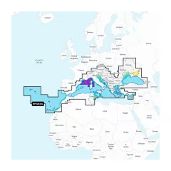
- Navionics Mediterranean and Black Sea NPEU643L
- Detailed information about the Mediterranean and Black Seas
- MicroSD card (32GB, SD adapter included)
- Includes the Mediterranean and Black Sea regions
- 1 year of free updates
- Route guidance
Integrated maps for a wide range of chartplotters
Navionics+ marine charts are a comprehensive solution that combines clear, reliable coastal/inland content with advanced navigation features. They support a wide range of chartplotter brands. Navionics chart data can be previewed for free in the Navionics WebApp.
Always ensure that the map card is compatible with your device before ordering.
Comprehensive mapping solution
Get detailed maps that include coastal features, lakes, and rivers, for a wide range of compatible chartplotters. Integrated coastal and inland lake content helps boaters worldwide.
Daily map updates
The charts are constantly updated with new and changed content. Thousands of updates are made every day. You also get a one-year subscription to get daily chart updates via the Navionics Chart Installer software.
Route guidance between ports
Advanced route guidance technology2 calculates route suggestions between ports based on boat settings, chart data and most frequently traveled routes.
Curves up to 0.5m apart
Making both fishing and navigation easier, the curves drawn at intervals of up to 0.5 meters clearly show the bottom shapes on fishing maps and in detail, for example in marshes, canals, harbors and marinas.
Advanced map settings
Change the way Navionics charts are displayed and focus on the information that matters to you. Highlight shallow areas, adjust the density of curves, or select a fishing area.
Community edits
Downloadable community edits provide useful local information in the Navionics Boating app, from users, and you can view the data on your compatible chartplotter.
Plotter synchronization
For example, you can transfer routes and markers, update maps between the chartplotter card and the mobile app wirelessly, activate or renew your map subscription, and download sonar logs4.
Real-time SonarChart™ maps
Create your own maps as you go. Watch as new 0.5m HD depth maps are created in real time as your boat moves through the water. Get more premium features with Navionics Platinum+ charting solutions:
- Accurate shading
-Downloadable shading5 shows the shapes of the base with colors and shadows, making it easier to interpret and clearer than just curved lines.
- Accurate satellite images
-Downloadable high-resolution satellite imagery5 gives you a realistic view of your surroundings, which is especially handy when arriving in unfamiliar ports.
- Aerial photos
-Ports, marinas, bridges, docks, boat ramps, dams and navigational landmarks are particularly clearly visible in aerial and surface imagery, improving situational awareness above the water surface.
3D view
Unique 3D views give you an additional perspective above and below the water surface to enhance situational awareness as key features are highlighted.
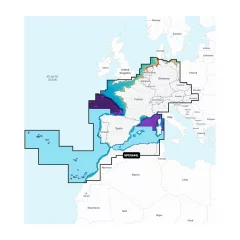
- Covers the sea areas of Central and Western Europe.
- 1 year of free updates
- Route guidance
The new EU644L is by far the most popular chart card for chartplotters and combination devices. The EU644L has replaced the old 44XG chart card. It is compatible with Lowrance, Raymarine, Simrad, B&G and Hummingbird devices. The chart card is supplied in an SD adapter, which contains a smaller microSD card.
Navionics chart data can be accessed in advance for free in the Navionics WebApp service.
Always ensure that the map card is compatible with your device before ordering.
- MicroSD card (1GB or 2GB, SD adapter included)
- 12 months of free updates.
COVERAGE:
- Sea areas: Entire Baltic Sea
- Finnish lakes: All the largest lakes and bodies of water and numerous smaller lakes
- Swedish lakes: Vänern and Vättern and other smaller lakes
- All Navionics charts also include small boat lanes
- 12 months of free updates. Requires registration of the chart card in the Navionics online service within 2 months of chart purchase.
- MicroSD card (32GB, SD adapter included)
- Requires registration of the chart card in the Navionics online service within 2 months of chart purchase.
- NOTE! You can choose between a 1GB or 2GB card with map data. This card also works in older devices that cannot handle 32GB or 64GB cards.
A convenient way to update your old Navionics, C-map, Lighthouse etc. chart card to the latest Navionics+ 644L data. The old chart card is only needed to activate the Navionics Updates chart card. After activation, the old chart card is fully functional. The old chart card can only be used to activate one Updates card.
The Navionics+ Updates card gives you access to the most up-to-date Navionics+ chart content at a significantly lower cost than purchasing a new card. The product must be activated using your existing card using the Navionics Chart Installer software.
Navionics+ chart card features
- The comprehensive mapping solution provides detailed maps that include coastal, lake and river data, and supports a wide range of compatible chartplotters, helping boaters worldwide.
- Daily chart updates ensure a constant supply of content, with thousands of updates made daily. A one-year subscription gives the user access to daily chart updates via the Navionics Chart Installer software.
- Port-to-port route guidance uses advanced technology to calculate route suggestions based on your boat's settings, chart data, and route traveled, making navigation easier.
- Curves as small as 0.5 meters provide highly accurate bottom maps that support both fishing and navigation. This level of detail is especially noticeable in marshes, canals and harbors.
- Advanced map settings allow the user to customize the way the map is displayed, such as highlighting shallow areas, adjusting the density of curves, or selecting a fishing area.
- Community edits enable downloadable local data from the Navionics Boating app and compatible chartplotters, bringing added value to users from the information shared by the community.
- Chartplotter sync allows you to transfer routes and markers between both the chartplotter and the mobile app wirelessly, as well as activate chart subscriptions and download sonar logs.
- Real-time SonarChart™ maps allow you to create your own daily maps as you go, with 0.5m HD depth maps generated as your boat moves through the water.
- Update your old chart card to the latest Navionics+ Large chart data
- With the Navionics Updates card you can update your old Navionics, C-map or Lighthouse chart to Navionics+ 644L chart data.
- Area: 644L: Baltic Sea + Finnish lakes
- Your old card may be a card from a different region or a smaller region
- The Updates card includes 12 months of free map updates.


