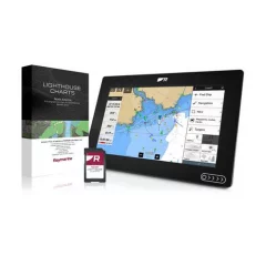
Raymarine Lighthouse Charts
Raymarine LightHouse electronic chartsTuoteryhmät
Raymarine Lighthouse Charts -ryhmän tuotteet
Kampanja
Raymarine LightHouse charts represent the next generation of electronic charts for Axiom and Element series displays. They provide safe and clear navigation with high-resolution chart images. The charts are based on official hydrographic sources, ensuring excellent readability and ease of use. The high quality and accuracy enhance the navigation experience both day and night. LightHouse charts add detail to Raymarine displays, making boating safer and more efficient.
Four different color palettes ensure optimal visibility in all lighting conditions. Map symbol controls let you customize the maps to your preferences. With a LightHouse Premium subscription, you get continuous map updates, a larger database of points of interest (POI), and more detailed satellite imagery for smooth navigation.
Features
- Customizable map symbols: Adjust the size of nautical markers, points of interest, and other icons to manage map information.
- Different color options: Day, dusk, night, and bright light modes help your eyes adapt to changes in lighting and make the map more comfortable to read.
- Customizable maps: Choose from the professional S-52 chart view or the LightHouse recreational chart that highlights key navigational information.
- Realistic view: High-resolution Mapbox satellite imagery provides a detailed view of beaches, shallow water areas, and streets.
- Premium Mode: With a LightHouse Premium subscription, you can update maps and download additional content on your mobile device.
Specifications
- Region: Sweden
- Format: Pre-installed MicroSD card
- Compatibility: Raymarine Axiom, Axiom+, Axiom Pro, Axiom XL and Raymarine Element
- System requirements: LightHouse V3.13 or later
- Note: Twilight and night modes, as well as changing the size of text and depth numbers, are not available on Element series devices (however, the size of nautical markers can be adjusted).
- Latest Raymarine chart
- Covers all of Sweden
- Compatible with Axiom and Element series

Kampanja
Next generation electronic marine charts for Raymarine's Axiom and Element series chartplotters
LightHouse maps make navigation on Raymarine Axiom and Element displays even clearer. Based on official hydrographic chart sources, LightHouse maps deliver the best possible readability, intuitive navigation and premium quality. Four distinct color palettes provide the best possible viewing conditions 24/7, and map symbol commands let you customize the maps to your preferences. With a LightHouse Premium map subscription, you get continuous map updates, an expanded library of points of interest (POI) and enhanced satellite imagery for more efficient and versatile marine navigation.
Take control of your local waters with LightHouse charts. Discover visually stunning, ultra-clear customizable charts with shaded depth contours and detailed points of interest that only Raymarine can offer. LightHouse charts reveal every detail, allowing you to explore the area without limits. LightHouse charts are compatible with Raymarine Axiom, Axiom+, Axiom Pro, Axiom XL and Raymarine Element displays
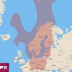
- Preloaded map (Northern Europe)
- Size 32 GB microSD card
- REQUIRES AXIOM OR ELEMENT SERIES WITH LATEST LIGHTHOUSE SOFTWARE
- v1.3.8
- Norway, Sweden, Finland, Estonia, Latvia, Lithuania, Poland, Germany, Denmark, Switzerland, Austria, Czech Republic, Hungary, Slovakia
- New regions required an update, Baltic countries require an update from Raymarine's website


