Savvy Navvy worldwide marine charts and navigation app for Android and Apple devices


- Clear and simple nautical charts of the entire world
- One-year license
- You will receive a code to activate the nautical charts.
- Savvy Navvy is available for both iOS and Android devices
- Many features that make boating easier;
- Intelligent route planning
- Over the Horizon AIS (via internet connection)
- GPS information
- Marine weather forecast
- Cloud and rain radar
- Fuel efficiency
- Import waypoints from other programs
- Port and anchorage information
- Anchor alarm
- Satellite mode
"It's like Google Maps for Boats"
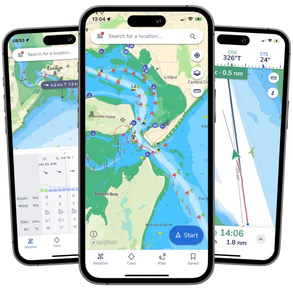
Savvy Navvy is a versatile navigation app that combines several boating-related features into one easy-to-use package. The app provides users with access to nautical charts, weather forecasts, tide information, and route planning tools. It aims to make boating safer and more enjoyable by providing all the necessary information in one app.
Features
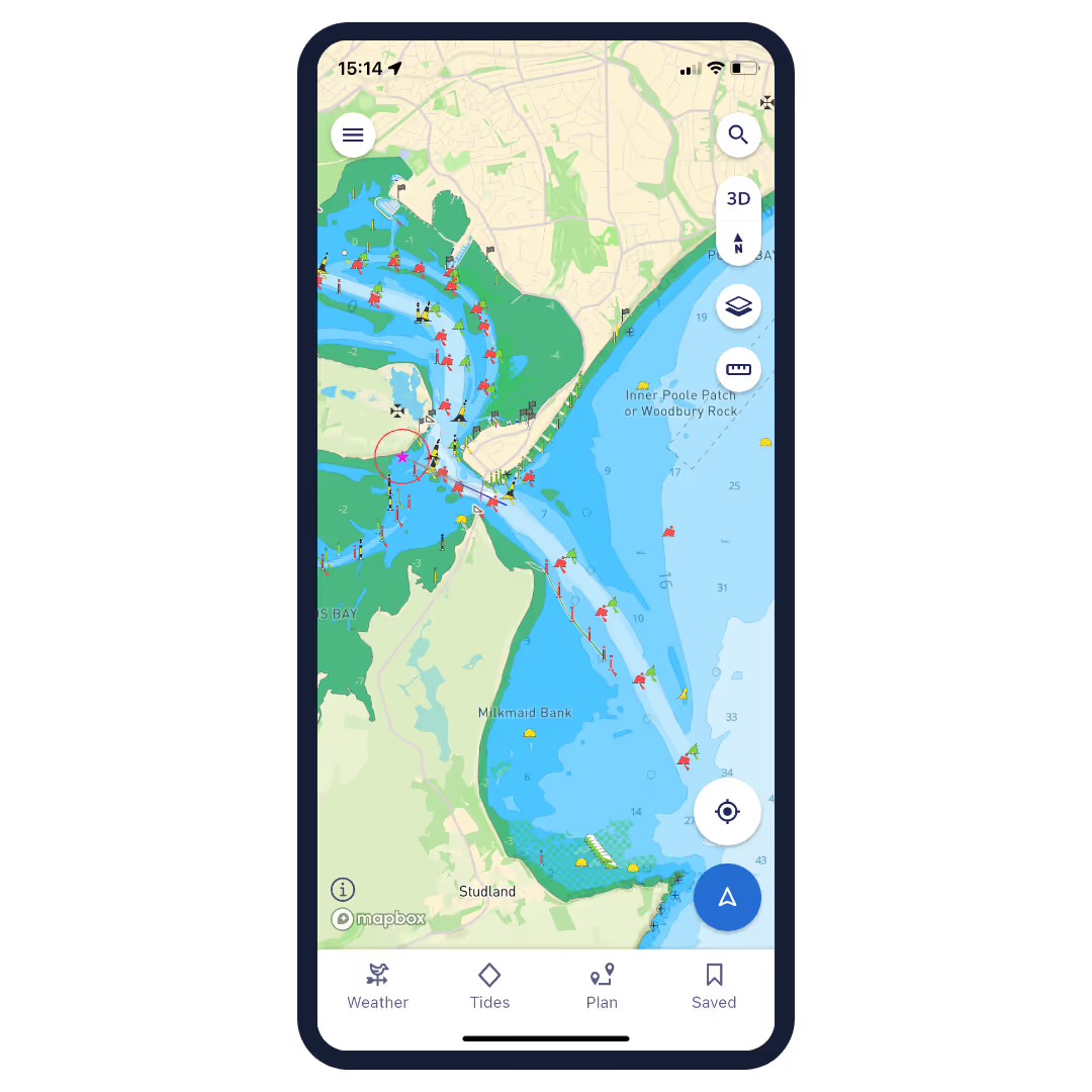
- Clear and simple nautical charts that present essential nautical information without unnecessary clutter.
- Route Planning: Allows you to plan a route quickly and easily, taking into account boat settings, weather conditions and tides.
- Estimated Time of Arrival (ETA): Automatically calculates the estimated time of arrival based on winds, weather, tides, and chart data.
- Tide data: Access data from thousands of tide stations around the world, including the direction and strength of tidal currents.
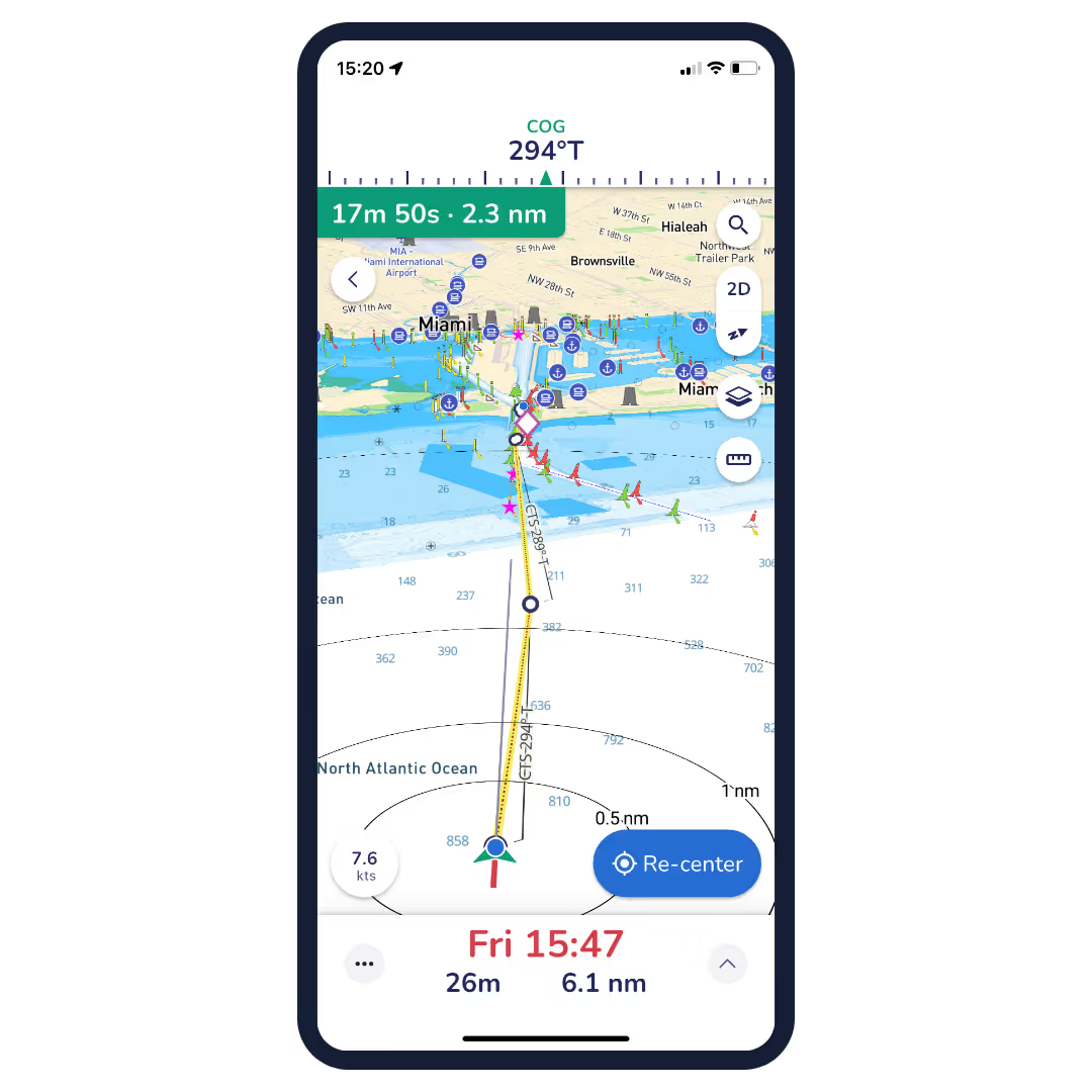
- GPS Tracking: Allows real-time location tracking and viewing of course over ground (COG) and speed over ground (SOG).
- Weather Forecasts: Shows forecasted wind directions and strengths, as well as other weather conditions for the selected area.
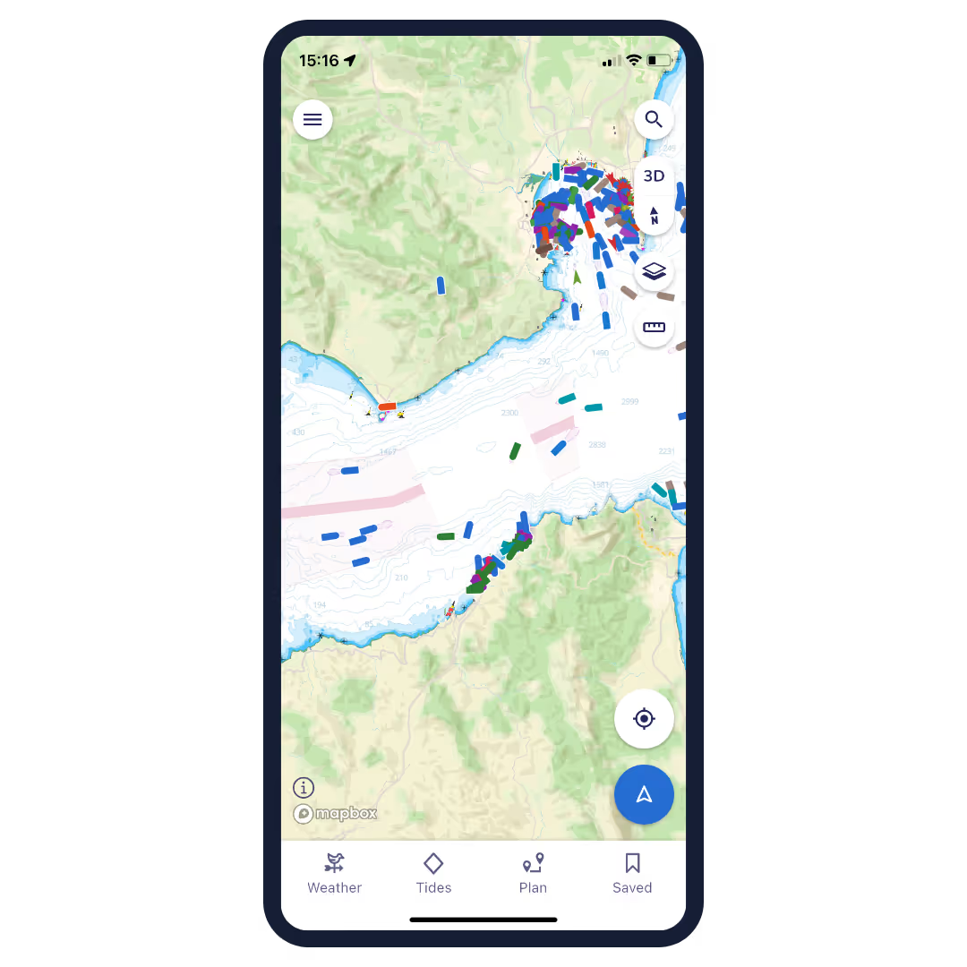
- Satellite view: Allows for a closer look at ports, anchorages, and other points of interest.
- Offline maps and weather: Ability to download maps and weather data in advance so you can use them without an internet connection.
Savyy Navyy nautical charts:
Savvy Navvy licenses nautical charts from the United Kingdom Hydrographic Office (UKHO), NOAA and other official hydrographic authorities around the world. Savvy charts are built from the ground up by designers to present essential nautical information in a clear and easy-to-read interface.
Over the Horizon AIS (OHA)
Improve safety by increasing awareness of vessels around you. Using your phone's internet connection, we stream real-time vessel information such as speed, distance, MMSI, position, course of course (COG) and destination.
GPS active tracking
See your real-time location and check your course over ground (COG) and speed over ground (SOG). Center circles around your location quickly illustrate the distance from you to key landmarks around you.
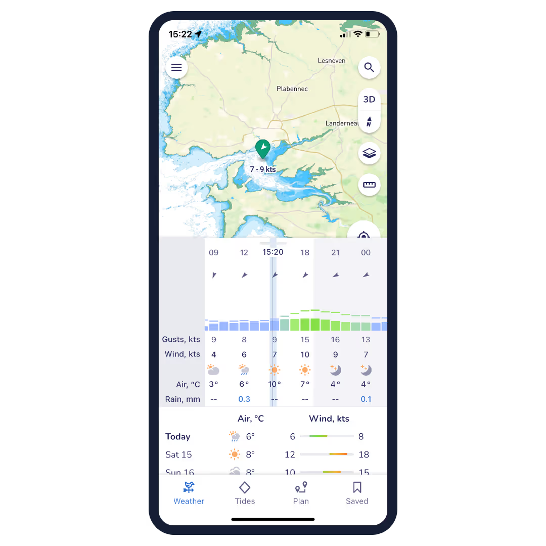
Marine weather forecast
You don't have to be a meteorologist to get the most out of your weather data. Savvy Navvy uses ECMWF technology to combine multiple weather forecasts into a more comprehensive one. Scroll through the coming days to see changing wind directions, strengths and weather conditions.
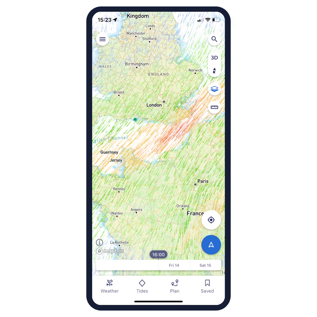
Cloud and rain radar
This overlay lets you view changing weather patterns in your area. A handy tool to help you avoid annoying showers and gusty weather conditions.
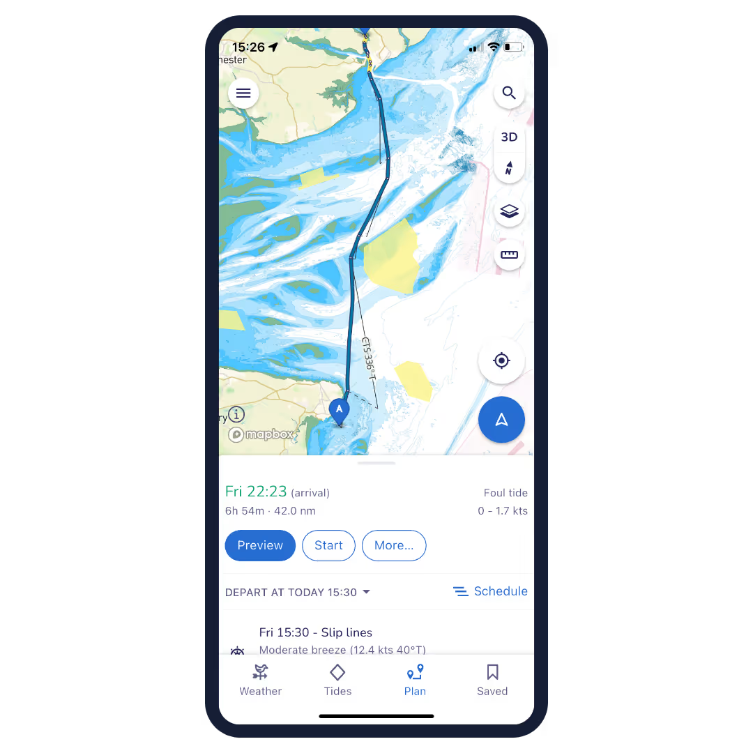
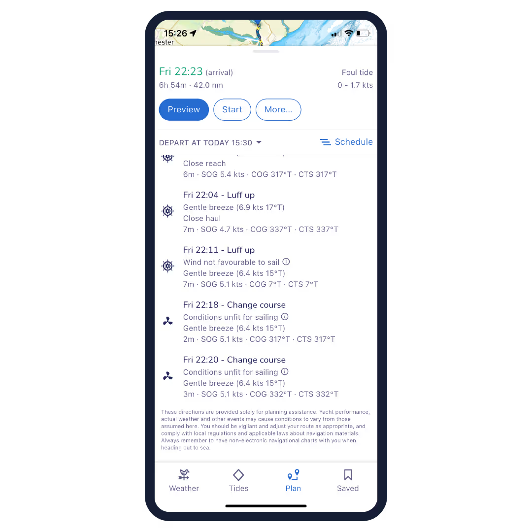
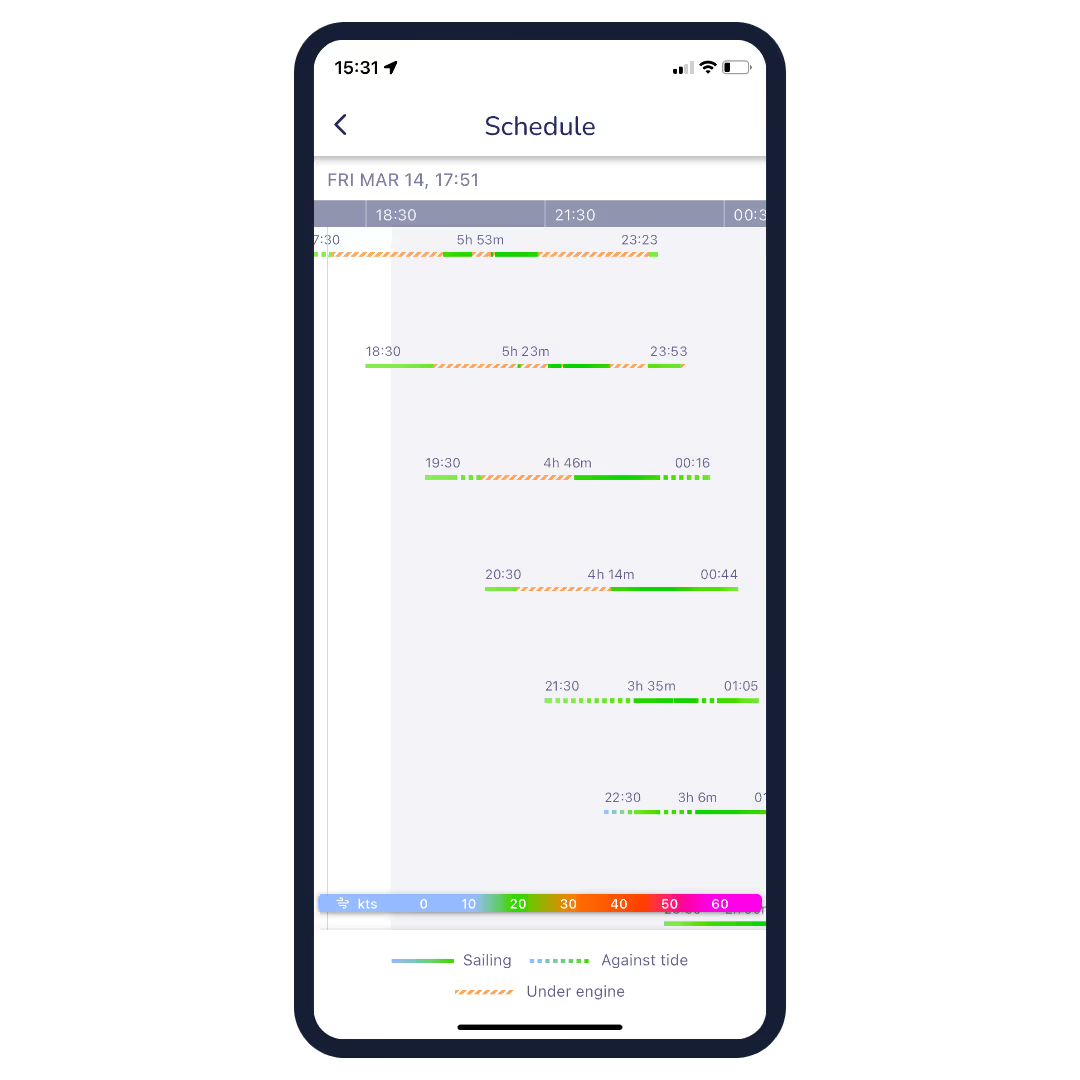
Intelligent route planning
Easily check your traditional navigation for extra confirmation and peace of mind. The program plans your route based on departure time, your boat information, chart data, and wind, weather, and tide information – providing you with a comprehensive and safe itinerary.
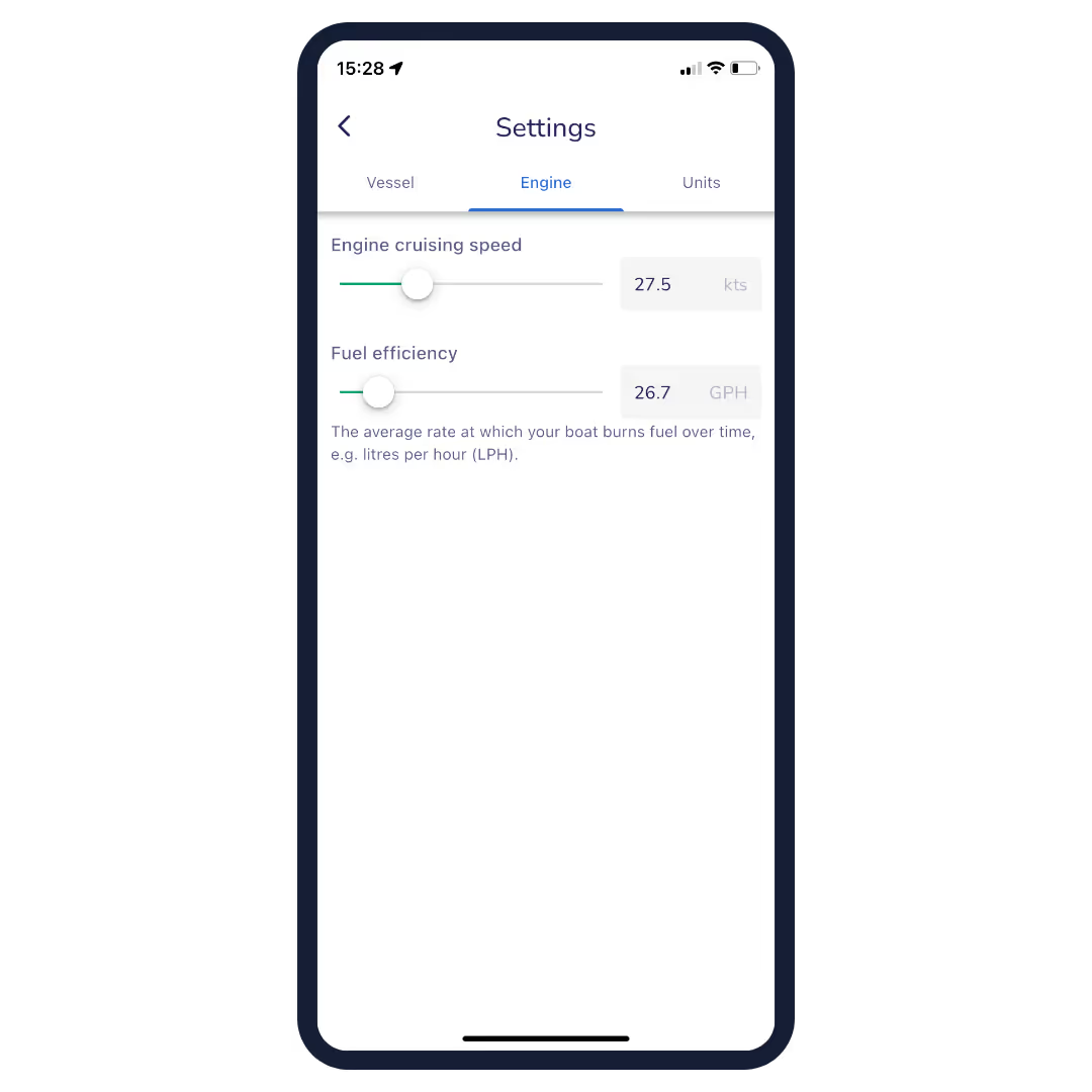
Fuel efficiency
No one likes the feeling of running out of fuel. Customizable boat-specific settings help you estimate fuel consumption for your planned route based on engine speed and boat fuel efficiency.
Import waypoints
Import your notes from other navigation tools and see all your saved locations in the Savvy app. This way, your important information continues to enhance your boating experience – while you enjoy the Savvy features you love most.
Port and anchorage information
Boat like a local – the most important information at your fingertips! Select a port or anchorage icon to see essential information about the quality of the bottom, weather protection, services, number of berths, maximum boat length, contact information and much more. Boat globally, think locally.
Anchor alarm
Sleep soundly with the Savvy Anchor Alarm. This easy-to-use tool lets you set your safety limits and alerts you if you drift out of your comfort zone.
Satellite mode
Explore the perfect spot in more detail with satellite mode. This handy overlay gives you a more detailed view of ports and anchorages, so you can make sure you're choosing the best option.
Tuotenr: 153068
- Clear and simple nautical charts of the entire world
- One-year license
- You will receive a code to activate the nautical charts.
- Savvy Navvy is available for both iOS and Android devices
- Many features that make boating easier;
- Intelligent route planning
- Over the Horizon AIS (via internet connection)
- GPS information
- Marine weather forecast
- Cloud and rain radar
- Fuel efficiency
- Import waypoints from other programs
- Port and anchorage information
- Anchor alarm
- Satellite mode
"It's like Google Maps for Boats"
Savvy Navvy is a versatile navigation app that combines several boating-related features into one easy-to-use package. The app provides users with access to nautical charts, weather forecasts, tide information, and route planning tools. It aims to make boating safer and more enjoyable by providing all the necessary information in one app.
Features
- Clear and simple nautical charts that present essential nautical information without unnecessary clutter.
- Route Planning: Allows you to plan a route quickly and easily, taking into account boat settings, weather conditions and tides.
- Estimated Time of Arrival (ETA): Automatically calculates the estimated time of arrival based on winds, weather, tides, and chart data.
- Tide data: Access data from thousands of tide stations around the world, including the direction and strength of tidal currents.
- GPS Tracking: Allows real-time location tracking and viewing of course over ground (COG) and speed over ground (SOG).
- Weather Forecasts: Shows forecasted wind directions and strengths, as well as other weather conditions for the selected area.
- Satellite view: Allows for a closer look at ports, anchorages, and other points of interest.
- Offline maps and weather: Ability to download maps and weather data in advance so you can use them without an internet connection.
Savyy Navyy nautical charts:
Savvy Navvy licenses nautical charts from the United Kingdom Hydrographic Office (UKHO), NOAA and other official hydrographic authorities around the world. Savvy charts are built from the ground up by designers to present essential nautical information in a clear and easy-to-read interface.
Over the Horizon AIS (OHA)
Improve safety by increasing awareness of vessels around you. Using your phone's internet connection, we stream real-time vessel information such as speed, distance, MMSI, position, course of course (COG) and destination.
GPS active tracking
See your real-time location and check your course over ground (COG) and speed over ground (SOG). Center circles around your location quickly illustrate the distance from you to key landmarks around you.
Marine weather forecast
You don't have to be a meteorologist to get the most out of your weather data. Savvy Navvy uses ECMWF technology to combine multiple weather forecasts into a more comprehensive one. Scroll through the coming days to see changing wind directions, strengths and weather conditions.
Cloud and rain radar
This overlay lets you view changing weather patterns in your area. A handy tool to help you avoid annoying showers and gusty weather conditions.
Intelligent route planning
Easily check your traditional navigation for extra confirmation and peace of mind. The program plans your route based on departure time, your boat information, chart data, and wind, weather, and tide information – providing you with a comprehensive and safe itinerary.
Fuel efficiency
No one likes the feeling of running out of fuel. Customizable boat-specific settings help you estimate fuel consumption for your planned route based on engine speed and boat fuel efficiency.
Import waypoints
Import your notes from other navigation tools and see all your saved locations in the Savvy app. This way, your important information continues to enhance your boating experience – while you enjoy the Savvy features you love most.
Port and anchorage information
Boat like a local – the most important information at your fingertips! Select a port or anchorage icon to see essential information about the quality of the bottom, weather protection, services, number of berths, maximum boat length, contact information and much more. Boat globally, think locally.
Anchor alarm
Sleep soundly with the Savvy Anchor Alarm. This easy-to-use tool lets you set your safety limits and alerts you if you drift out of your comfort zone.
Satellite mode
Explore the perfect spot in more detail with satellite mode. This handy overlay gives you a more detailed view of ports and anchorages, so you can make sure you're choosing the best option.
Tuotenr: 153068
Suosittelemme sinulle


