Chartplotter GPS Antennas
You’ll find high-quality GPS antennas for chartplotters in Marinekauppa’s wide selection.Chartplotter GPS Antennas -ryhmän tuotteet
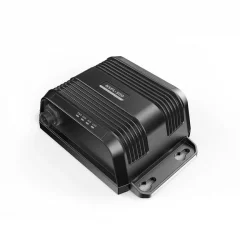
Avoid the hassle and expense of installing a second antenna using your current single antenna with VHF/AIS/FM by adopting the lightweight and compact NSPL 500 antenna splitter. The NSPL 500 AIS system lets you see and be seen on the water, whether you're navigating busy shipping lanes or busy ports.
Features
- Plug and Play: FM connector for SonicHub™ 2 or other compatible FM stereo unit.
- Light weight: Only 260 grams.
- Waterproof: IPX7 standard.
- Low power consumption: Perfect for sailboats and powerboats, the NSPL 500 has an average power consumption of less than 150 mA, 12 V DC.
- Wide voltage range: The NSPL 500 is suitable for 12 or 24 V DC systems and supports a wide range of input voltages from 9.6 V to 31.2 V DC.
- Highly efficient , low insertion loss: The NSPL 500's efficient design means no insertion loss during AIS and VHF reception and low insertion loss during AIS and VHF transmission.
- Splitter for VHF/AIS/FM antennas
- Waterproof
- Low power consumption

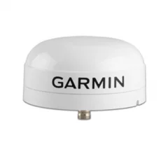
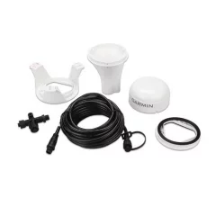
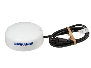
This rugged passive antenna is a replacement for the GA™ 29 GPS antenna and is packaged in a small waterproof housing. The antenna can be mounted in three different ways: pole, surface or under-deck (under fiberglass covers). Includes surface, pole and under-deck mounting brackets, mounting hardware, antenna cable (10 m / 32 ft) and installation instructions.

White Garmin patch cursor offers high accuracy
Accurate data means safer navigation!
Specifications
- Dimensions: Ø91.6 x H49.5 mm
- Weight: 201g
- Cable length: 6 m
- Temperature range: -30°C - 80°C
- Housing: Fully sealed and impact-resistant plastic alloy (waterproof IPX7)
- Safety distance to compass: 150 mm
- Voltage: 9-32 VDC
- Dimensions: Ø91.6 x H49.5 mm
- Weight: 201g
- Cable length: 6 m
- Temperature range: -30°C - 80°C
- Housing: Fully sealed and impact-resistant plastic alloy (waterproof IPX7)
- Safety distance to compass : 150 mm
- Voltage : 9-32 VDC
- NMEA2000
- Current consumption: 30mA (1 LEN)
- SeaTalkng and NMEA2000 compatible (device network adapter cable required)
- Perfect for low-profile surface mounting
- Optional pole mount
- GPS receiver 72-channel
- Ultra-fast 10 Hz location updates
- GPS compatible with satellite separation. Space-Based Augmentation System (SBAS) enabled with WASS, EGNOS, MSAS and GAGAN support
- GLONASS-compatible GNSS receiver

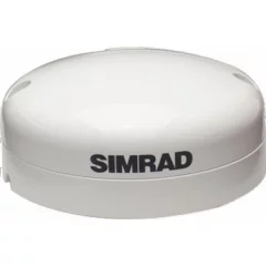
Simrad GPS antenna/Electronic compass
The Simrad GS25 GPS antenna is the perfect GPS device for any navigator who needs highly accurate and fast vessel position and speed updates.
Unlike antennas that only transmit position, the GS25 reports the boat's precise magnetic heading at all speeds and displays it as a radar/chart overlay.
The GS25 is easy to connect to any Simrad NS series multifunction display or NMEA 2000® network.
It is completely waterproof and can be installed on any boat, either flat or on a pole.
*Please note that this product is not suitable for use with MARPA or autopilot systems as they require an electronic compass such as the RC42.
Product package contents:
- Antenna GS-25
- N2K-T-RD network T-connector
- Post mount GS25/ZG100/POINT-1
- N2KEXT-15RD 15 ft. power extension cord
- Easy connection
- Waterproof
- Surface and column mounting


OneFix is Digital Yacht’s newly introduced hi-performance GNSS (global navigation satellite system) sensor. Using multiple satellite networks and new dual band technology, it’s been designed to offer super-accurate positioning (typically better than 1m) and importantly has robust anti-spoofing algorithms built in for more reliable navigation. It can also fit to just about any navigation system (including legacy units) plus connect to iPads and tablets and the latest multi-function NMEA 2000 compatible displays. OneFix promises to bring highly accurate, more reliable navigation to any boater.
You may be familiar with the term GPS but GNSS is the more formal name for all the different satellite networks including Glonass, Galileo, Beidou and NavIC that can now also be used for positioning. Most modern marine electronic products can process signals from some of these networks and automatically compute which to utilise to give you the best accuracy.
Another major development in GNSS over the last year has been the ongoing deployment of multi band GNSS. Signals from some satellite networks are now transmitted on L1 and L5 bands and by utilising a sophisticated dual band GNSS, you’ll benefit from better accuracies and a more reliable fix in harsh conditions. Most traditional GPS’s, MFD’s and plotters just use L1 frequencies so can’t benefit from this latest technology.
KEY FEATURES
GPS, Galileo, Beidou and NavIC constellations
OneFix incorporates a dual band (L1 and L5) processor and works with GPS, Galileo, NavIC and Beidou to calculate a fix. Glonass (the Russian based system) is available as an option with a 2nd active antenna making for a very advanced system.
It goes a step further too by using an advanced algorithm to compare position fixes across all networks and frequencies to minimise spoofing and positional inaccuracies.
The result is a highly reliable position fix which offers typically sub 1m accuracy.
NMEA 0183, 2000 & Wi-Fi Interfaces
OneFix has also been designed to connect to older systems via legacy NMEA 0183 as well as more modern systems with NMEA 2000.
Thanks to its password protected Wi-Fi interface, OneFix provides wireless NMEA 2000 data output for charting apps such as Navionics, TimeZero, AquaMaps, Navimetrix and hundreds more. It multiplexes NMEA 2000 AIS, wind, depth, compass, and speed data to the GNSS navigation output, transforming a Tablet, PC, Smartphone or iPad into a full-function, high-precision navigation device with L1+L5 capability.
Data Logging, Marks & Tracks
OneFix built-in web interface also incorporates data logging and event marking capabilities so key points of a voyage (or even fishing hotspots) can be logged to internal memory. You can download event markers and track log files in GPX and KML formats for easy overlay on Google Maps and charts.
OneFix also supports dual external switch inputs and an “Add Mark” function in the web interface for precise event marking. For advanced analysis, full NMEA 2000 raw data logging is also available.
MOB Functionality & NMEA 2000 Alerts
OneFix can generate industry-standard alerts on the NMEA 2000 bus, enabling “pop-up” notifications on compatible MFDs. When paired with the NavAlarm sounder, it provides an ultra-loud audible alarm to ensure critical warnings are never missed. OneFix generates alerts for position inaccuracy, positioning spoofing or errors, offering enhanced safety and reliability on the water.
OneFix also supports a simple switch input for an MOB, such as Digital Yacht’s MOB input panel, and will generate a synthetic AIS MOB message on the NMEA 2000 network. By pressing the button on the Digital Yacht MOB panel, OneFix will generate NMEA 2000 MOB (man overboard) alerts.
STL Capability
OneFix also has an input for alternative positioning systems such as STL from Iridium. These use triangulation from substitute satellite networks to provide an alternative albeit less accurate position fix (approx. 50m) but have the advantage of a more powerful signal and alternative frequency outside of traditional GNSS constellations.
OneFix can accept data from these systems via NMEA 0183 and switch between networks allowing for a flexible multi-input, hub-based solution.
EASY CONFIGURATION
Accessing OneFix web interface is very simple. Simply use any phone, PC, Mac or tablet to logon to the built-in web interface and no internet connection is required.
Simply open your web browser (Google Chrome, Safari, Mozilla, etc.), enter the OneFix‘s IP address (which is always 192.168.1.1) and you can access the built-in web interface.
Through the interface, you can access advanced NMEA 2000 network diagnostics, offering features such as a detailed device list and PGN displays to simplify the handling of complex interfacing issues. It also enables users to conveniently select sources for NMEA 2000 multiplexed data, ensuring greater flexibility and control over network management.
SPECIFICATIONS
Hi precision GNSS system with accuracies typically better than 1m
Utilises GPS, Galileo, Beidou and NavIC constellations – with optional Glonass sensor
L1/L5 dual band receiver and antenna
Advanced anti spoofing algorithm continuously monitors each constellation and generates alerts if issues detected
NMEA 0183 and NMEA 2000 outputs
WiFi interface for iPad and tablet navigation
Web interface for setup and satellite analytics
Integrated data logger with export of points by GPX/KML
NMEA 2000 wind, depth, speed, AIS and compass data multiplexed to wireless output for use with apps
Optional MOB switch input to generate synthetic AIS MOB SART messages on NMEA 2000
Alarms for errors via NMEA 2000 alerts
Buzzer/relay output for external alarms
1PPS timing output
- Hi precision GNSS system with accuracies typically better than 1m
- Utilises GPS, Galileo, Beidou and NavIC constellations – with optional Glonass sensor
- L1/L5 dual band receiver and antenna
- Advanced anti spoofing algorithm continuously monitors each constellation and generates alerts if issues detected
- NMEA 0183 and NMEA 2000 outputs
- WiFi interface for iPad and tablet navigation
- Web interface for setup and satellite analytics
- Integrated data logger with export of points by GPX/KML
- NMEA 2000 wind, depth, speed, AIS and compass data multiplexed to wireless output for use with apps
- Optional MOB switch input to generate synthetic AIS MOB SART messages on NMEA 2000
- Alarms for errors via NMEA 2000 alerts
- Buzzer/relay output for external alarms
- 1PPS timing output
Point-1 features
- NMEA 2000® position and heading sensor.
- Supports GPS and GLONASS.
- Supports SBAS including WAAS/EGNOS/MSAS.
- 10 Hz refresh rate.
- The built-in electric compass provides accurate 10Hz heading information for the radar overlay function.
- NOT recommended as a primary source for MARPA or Autopilot.
In the package
- Point-1 antenna + 1.22m (4') antenna cable
- N2K T-branch
- Antenna cone
- Mounting screws
- Installation instructions
- NMEA 2000® position and heading sensor
- GPS and GLONASS support, Galileo compatible with future software update
- SBAS support including WAAS/EGNOS/MSAS
- 10Hz updates for smooth and accurate positioning
- The integrated electronic compass provides 10 Hz heading for chart stabilization and radar overlay, as well as the vessel's precise heading relative to the ground, even at low speeds.
- Compact, durable design for all aquatic environments, completely waterproof
- Includes pole mount
- Not recommended for use with MARPA or Autopilot