Garmin Fishfinders
Garmin fish finders are highly accurate and now also available with live sonar technology.Garmin Fishfinders -ryhmän tuotteet
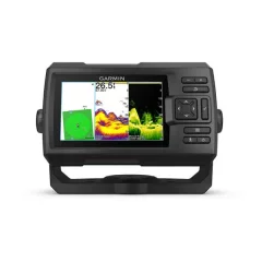
7' chartplotter/sounder with buttons and GT20 transom sensor. With sharp, clear traditional sonar and bright ClearVü sonar, fish can’t escape. High-contrast, vibrant scanning sonar color palettes make it easy to distinguish targets and structure. ECHOMAP UHD2 supports multiple Garmin transducers for two types of sonar: Garmin traditional sonar and ClearVü scanning sonar.
- Screen size: 7'
- No touchscreen
- Includes GT20-TM transducer
- Accurate ClearVü sonar (includes GT-20 transom sensor)
- The bright button-operated display or 7' is designed with convenience first
- You get two views1: Garmin's traditional CHIRP sonar and ClearVü scanning sonar.
- Underwater subjects look even better with high-contrast, vibrant color palettes.
- Sharing data between compatible chartplotters is easy with Wi-Fi® connectivity.
- Enjoy the best maps: Garmin Navionics+ and Garmin Navionics Vision+.

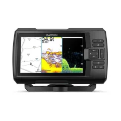
7" touchscreen and GT-54 side-scan sonar transom sensor. With sharp, clear traditional sonar and bright ClearVü and SideVü scanning sonar, fish can’t escape. Plus, ECHOMAP UHD2 supports LiveScope™ real-time scanning sonar. The bright, clear colors of scanning sonar make it easy to distinguish targets and structure. The ECHOMAP UHD2 supports a wide range of Garmin transducers.
- Screen size: 7"
- Touchscreen and buttons
- Includes GT54 transducer
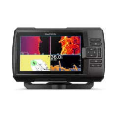
9' chartplotter with touchscreen and sonar transducer. With sharp, clear traditional sonar and bright ClearVü and SideVü scanning sonar, fish can’t escape. In addition, ECHOMAP UHD2 supports LiveScope™ real-time scanning sonar. The bright, clear colors of scanning sonar make it easy to distinguish targets and structure. The ECHOMAP UHD2 supports a wide range of Garmin transducers and is networkable with other Garmin devices.
- Screen size: 9'
- Touchscreen and buttons
- Includes GT56 transducer
- A transom sensor with an oblique sonar is included.
- Three types of sonar: Garmin traditional sonar, ClearVü™ and SideVü™ sonar.
- If you use another ECHOMAP UHD2 chartplotter, you can share sonar, waypoints, and routes wirelessly.
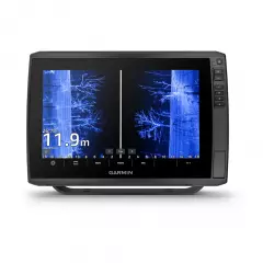
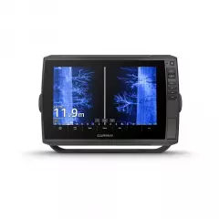
Versatile chartplotter and sonar with a large 10-inch touchscreen display that is clearly readable even in bright sunlight and includes a wealth of excellent fishing features. In addition to the touchscreen, the device has shortcut keys on the right bezel, meaning the device offers both options for use depending on the situation or user preferences. The device supports Garmin Navionics+™ and Garmin Navionics Vision+™ charts and the transducer adds highly accurate scanning sonar, as well as traditional CHIRP sonar. The device is therefore designed especially for fishermen and boaters who value accurate map information, advanced sounding and many compatibility options with other boat devices.
- Screen size: 10"
- Touchscreen and buttons
- Sonar must be purchased separately
- Dimensions: 29.5 x 19.5 x 9.8 cm
- Weight: 1.8 kg
- Waterproof rating: IPX7, which means the device can withstand immersion in water up to 1 meter deep for 30 minutes.
- Display type: WXGA, IPS, which offers wide viewing angles and good image quality.
- Screen size: 21.7 x 13.6 cm; diagonal 21.7 cm.
- Screen resolution: 1280 x 800 pixels.
- Mounting options: mounting bracket or flush mounting
- In addition, button operation, i.e. both touchscreen and button operation
- Supports memory cards: 2 microSD cards, allowing for expandable storage for map data, waypoints and other data.
- Waypoints: 5000 waypoints, which can include locations you want to save and return to later.
- Trackpoints: 50,000 trackpoints that can record your movements and routes on the water surface.
- Tracks: 50 saved tracks, which means the device can store 50 separate tracks from different trips.
- Routes: 100 routes, which can include planned routes that you can follow and share on your device.
- GPS support: The device supports multiple satellite systems, which improves location accuracy.
- GLONASS: A Russian satellite system that improves positioning accuracy, especially in challenging environments.
- Galileo: A European satellite system that supports more precise positioning.
- BeiDou: A Chinese satellite system that increases positioning accuracy.
- Internal receiver: Built-in receiver that supports the use of multiple satellite systems.
- Receiver: 10 Hz receiver, which means the device updates the location 10 times per second, improving accuracy and real-time.
- NMEA 2000® compatible: The device is compatible with the NMEA 2000 network, allowing it to be connected to other boat devices, such as heading sensors, engines and autopilots.
- WAAS support: Support for the Wide Area Augmentation System (WAAS), which improves GPS location accuracy, especially in the United States.
Compatible maps:
- BlueChart g3: Coastal charts that provide detailed information about sea areas and navigational features, such as channels, depths, and hazards.
- BlueChart g3 Vision: An additional feature of BlueChart g3 charts that provides 3D views, optimized route suggestions, and additional information such as ports and harbor charts.
- Garmin Navionics+™: A great choice for anglers, featuring detailed coastal and inland maps, as well as fishing location and depth information.
- Garmin Navionics Vision+™: Offers advanced features such as 3D chart and harbor imagery that enhance navigation and route planning.
- TOPO 100K: Terrain maps that cover large areas and provide detailed information about landforms such as mountains, lakes, and rivers.
- Garmin Quickdraw Contours: Garmin's proprietary mapping software that allows users to create their own maps and depth locations in real time.
Chartplotter functions:
- AIS compatible: Ability to track the location of target vessels, improving safety and navigation at sea.
- DSC-compatible: Displays position information from a DSC-compatible VHF radio, facilitating emergency management and communication.
- Supports FUSION-Link™ compatible radios: Ability to connect and control FUSION-Link compatible audio systems.
- ActiveCaptain compatible: The ActiveCaptain app lets you manage your device settings, receive updates, and share data with your smart device.
Electrical information:
- Power input: 9–18 Vdc.
- Typical current consumption (12 V dc): 2.3 A.
- Maximum current consumption (12 V dc): 5 A.
- Maximum power consumption (10 V dc): 34 W.
Contacts:
- NMEA 2000® ports: 1 port that allows the device to communicate with other NMEA 2000 compatible devices.
- Garmin Marine Network™ ports: 2 ports (large connector) allowing for expandability and connectivity to other Garmin devices.
- 12-pin transducer ports: Allows connection to a scanning sonar.
- ANT+™ (connection): Wireless connection to various ANT+ compatible devices, such as heart rate monitors or other sensors.
- Garmin Wi-Fi® Network (Local Connection): Ability to connect to a local Wi-Fi network for data sharing and device management.
Package contents:
- ECHOMAP Ultra 102sv
- Charging/data cable
- Mounting bracket and quick-release bracket
- Sunshade
- Hardware
- Guides

Versatile chartplotter and sonar with a large 12-inch touchscreen display that is clearly readable even in bright sunlight and includes a wealth of excellent fishing features. In addition to the touchscreen, the device has shortcut keys on the right bezel, meaning the device offers both options for use depending on the situation or user preferences. The device supports Garmin Navionics+™ and Garmin Navionics Vision+™ charts and the transducer adds highly accurate scanning sonar, as well as traditional CHIRP sonar. The device is therefore designed especially for fishermen and boaters who value accurate map information, advanced sounding and many compatibility options with other boat devices.
- Screen size: 12'
- Touchscreen and buttons
- Sonar must be purchased separately
- Dimensions: 34.1 x 22.9 x 9.8cm
- Weight: 2.5 kg
- Waterproof rating: IPX7, which means the device can withstand immersion in water up to 1 meter deep for 30 minutes.
Touchscreen:
- Display type: WXGA, IPS, which offers wide viewing angles and good image quality.
- Screen size: 26.1 x 16.3 cm; diagonal 30.7 cm.
- Screen resolution: 1280 x 800 pixels.
- Mounting options: mounting bracket or flush mounting
- In addition, button operation, i.e. both touchscreen and button operation
- Supports memory cards: 2 microSD cards, allowing for expandable storage for map data, waypoints and other data.
- Waypoints: 5000 waypoints, which can include locations you want to save and return to later.
- Trackpoints: 50,000 trackpoints that can record your movements and routes on the water surface.
- Tracks: 50 saved tracks, which means the device can store 50 separate tracks from different trips.
- Routes: 100 routes, which can include planned routes that you can follow and share on your device.
- GPS support: The device supports multiple satellite systems, which improves location accuracy.
- GLONASS: A Russian satellite system that improves positioning accuracy, especially in challenging environments.
- Galileo: A European satellite system that supports more precise positioning.
- BeiDou: A Chinese satellite system that increases positioning accuracy.
- Internal receiver: Built-in receiver that supports the use of multiple satellite systems.
- Receiver: 10 Hz receiver, which means the device updates the location 10 times per second, improving accuracy and real-time.
- NMEA 2000® compatible: The device is compatible with the NMEA 2000 network, allowing it to be connected to other boat devices, such as heading sensors, engines and autopilots.
- WAAS support: Support for the Wide Area Augmentation System (WAAS), which improves GPS location accuracy, especially in the United States.
Compatible maps:
- BlueChart g3: Coastal charts that provide detailed information about sea areas and navigational features, such as channels, depths, and hazards.
- BlueChart g3 Vision: An additional feature of BlueChart g3 charts that provides 3D views, optimized route suggestions, and additional information such as ports and harbor charts.
- Garmin Navionics+™: A great choice for anglers, featuring detailed coastal and inland maps, as well as fishing location and depth information.
- Garmin Navionics Vision+™: Offers advanced features such as 3D chart and harbor imagery that enhance navigation and route planning.
- TOPO 100K: Terrain maps that cover large areas and provide detailed information about landforms such as mountains, lakes, and rivers.
- Garmin Quickdraw Contours: Garmin's proprietary mapping software that allows users to create their own maps and depth locations in real time.
Chartplotter functions:
- AIS compatible: Ability to track the location of target vessels, improving safety and navigation at sea.
- DSC-compatible: Displays position information from a DSC-compatible VHF radio, facilitating emergency management and communication.
- Supports FUSION-Link™ compatible radios: Ability to connect and control FUSION-Link compatible audio systems.
- ActiveCaptain compatible: The ActiveCaptain app lets you manage your device settings, receive updates, and share data with your smart device.
Electrical information:
- Power input: 9–18 Vdc.
- Typical current consumption (12 V dc): 2.5 A.
- Maximum current consumption (12 V dc): 5 A.
- Maximum power consumption (10 V dc): 36 W.
Contacts:
- NMEA 2000® ports: 1 port that allows the device to communicate with other NMEA 2000 compatible devices.
- Garmin Marine Network™ ports: 2 ports (large connector) allowing for expandability and connectivity to other Garmin devices.
- 12-pin transducer ports: Allows connection to a scanning sonar.
- ANT+™ (connection): Wireless connection to various ANT+ compatible devices, such as heart rate monitors or other sensors.
- Garmin Wi-Fi® Network (Local Connection): Ability to connect to a local Wi-Fi network for data sharing and device management.
Package contents:
- ECHOMAP Ultra 122sv
- Charging/data cable
- Mounting bracket and quick-release bracket
- Sunshade
- Hardware
- Guides
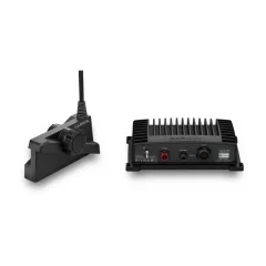
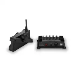
Real-time sonar ensures image accuracy
Image stabilization
Vibrant colors
Forward mode
Down mode
Perspective mode
In the package
- LiveScope GLS 10 Sonar black box
- Panoptix LVS34 sonar transducer
- Perspective stand
- Electric motor cylinder mount
- Sulfur tube rack
- Power cord
- 2-meter Garmin Marine Network cable (small connector)
- Network adapter cable
- Guides
- The image is clearly visible thanks to improved display clarity, transducer sensitivity and target separation.
- Sharper echo image and less noise and interference.
- Easily upgrade your existing LiveScope Black Box (GLS™ 10 sonar module) with a new transducer.
- The images have excellent contrast and clarity thanks to vibrant color palettes.
- You'll see everything you need with supported Forward, Down, and Perspective modes and the necessary stand.
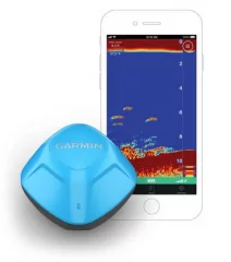
Find and catch more fish easily with the durable STRIKER Cast GPS sonar
In the package
- STRIKER Cast GPS
- Carrying case
- Flame (6 m)
- USB cable for charging
- Guides
- The device sends sonar data to the phone screen
- Free app for Apple or Android smart device
- You can also check the water temperature
- Built-in GPS lets you create custom Quickdraw fishing maps with elevation contours in 0.3-meter increments so you can remember (and perhaps share) the best fishing spots you find.
- To make using your sonar even easier, enable fish icons to see fish and their depth readings as images
- Weight 75g.
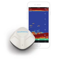
Find and catch more fish easily with the durable STRIKER Cast sonar
In the package:
- STRIKER Cast
- Carrying case
- Flame (6 m)
- USB cable for charging
- Guides
- The device sends sonar data to the phone screen
- Free app for Apple or Android smart device
- You can also check the water temperature
- Without GPS feature
- To make using your sonar even easier, enable fish icons to see fish and their depth readings as images.
- Weight 75g.
Garmin Striker Vivid 5cv is a sonar with GPS functionality. It allows you to track your routes and mark interesting places on the screen. Striker devices do not have an actual map base. However, they draw a depth chart map of the areas you are navigating and surveying with your boat. CV devices have an accurate ClearVü sonar that surveys directly downward from the boat. A transom sensor is included.
- Screen size: 5'
- Button-operated
- Includes GT20 transducer
- GPS - draws tracks and depth curves
- Dimensions 18.8 x 11.6 x 5.4cm
- Button-operated
- Screen size 6.5 x 10.8cm
- Screen resolution 800 x 480 pixels
- No map
Garmin Striker Vivid 7cv is a sonar with GPS functionality. It allows you to track your routes and mark interesting places on the screen. Striker devices do not have an actual map base. However, they draw a depth chart map of the areas you are navigating and surveying with your boat. The CV model includes ClearVü, which is a precise downward scanning sonar.
- Dimensions 23.5 x 14.0 x 5.8 cm (9.3 x 5.5 x 2.3 inches)
- Button-operated
- Screen size 8.6 x 15.4 cm
- Screen resolution 800 x 480 pixels
- GPS (no map available)
- Draws routes and depth curves
- Can mark destinations to return to using GPS
The Garmin Striker Vivid 7sv is a sonar, which includes a GPS function. It allows you to track your routes and mark interesting places on the screen. Striker devices do not have an actual map base. However, they draw a depth chart map of the areas you navigate and survey with your boat. The SV model includes SideVü, or side-view sonar.
- Screen size: 7'
- Button-operated
- Includes GT52HW transducer
- GPS (no map available)
- Dimensions 23.5 x 14.0 x 5.8cm
- Screen dimensions: 8.6 x 15.4cm
- Screen resolution 800 x 480 pixels
- Draws routes and depth curves
- Can mark destinations to return to using GPS
- Oblique echo sounder

Garmin Striker Vivid 9sv is a fishfinder with GPS functionality. It allows you to track your routes and mark interesting places on the screen. Striker devices do not have an actual map base. However, they draw a depth chart map of the areas you are navigating and surveying on your boat. The SV model includes SideVü, or side-view sonar.
- Screen size: 9'
- Button-operated
- Includes GT52HW-TM transducer
- Dimensions 28.2 x 16.5 x 6.0 cm (11.1 x 6.5 x 2.4 inches)
- Screen dimensions 11.2 x 19.8 cm
- Screen resolution 800 x 480 pixels
- Display type WVGA color display
- Weight 1.1 kg (2.4 lbs)
- Waterproof IPX7
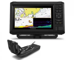
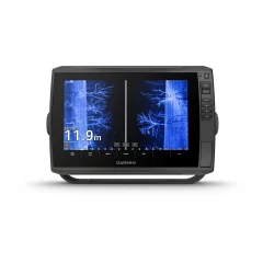
Garmin ECHOMAP Ultra 2 122sv – 12" chartplotter and sonar for demanding fishing
The Garmin ECHOMAP Ultra 2 122sv is a premium 12-inch chartplotter and sonar for active and demanding fishing. A large, bright touchscreen, ultra-high-definition UHD sonar, and extensive mapping and networking capabilities make it an excellent choice for anglers who want the best possible visibility and control on the water.
Bright 12” touchscreen
The large 12-inch touchscreen is easy to read even in direct sunlight. The larger display area allows for multiple views to be used simultaneously and makes interpreting maps and sonar images even easier.
GT56UHD-TM transom mount transducer included
All the tools for successful fishing. ECHOMAP Ultra 2 122sv comes with the GT56UHD-TM transducer , which offers a highly accurate and versatile sonar package:
- Traditional Garmin CHIRP sonar
- ClearVü™ UHD scanning sonar
- SideVü™ UHD scanning sonar
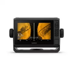
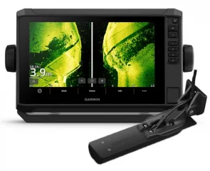
You can see the bottom structures, vegetation and fish with exceptional detail, almost photographically.
LiveScope™ sonar support
The device supports Garmin LiveScope™ sonar , which lets you see fish and structure in motion in real time (LiveScope transducers sold separately).
Accurate maps and navigation
Supports Garmin Navionics+™ and Garmin Navionics Vision+™ charts , which provide:
- extensive inland and coastal coverage
- daily map updates
- Auto Guidance+™ technology for route planning
Wireless connections and smart features
- Wireless sharing of sonar, waypoints and routes
- Saving screenshots
- ActiveCaptain® mobile app (software updates, Garmin Quickdraw™ maps)
Multi-band GPS
Multi-band GNSS improves positioning accuracy, especially in areas where GPS signals are weak or reflected.
Wide compatibility
- NMEA 2000®
- Fusion Link™
- Garmin Force® trolling motor
Bright and accurate colors
The bright and high-contrast color palettes of the UHD scanning sonar make it easy to identify targets, structures and fish, even in challenging conditions.
ActiveCaptain® app
By pairing your chartplotter with the ActiveCaptain® mobile app, you get access to:
- software updates
- screen recording
- Garmin Quickdraw™ Community Maps
Compatible with Force® trolling motor
Wireless connection to a Garmin Force® trolling motor allows you to navigate to waypoints, draw and track routes directly from your chartplotter.
Easy to remove and transport
The included quick-release mounting bracket makes installing and removing the device quick and easy.
In the package:
- ECHOMAP Ultra 122sv
- GT56UHD-TM sonar transducer
- Power cord
- Mounting bracket and quick-release bracket
- Sunshade
- Hardware
- Guides
- Display: 10"
- Touchscreen
- Dimensions: 29.5 x 19.5 x 9.8 cm
- Weight: 1.8 kg
- Waterproof rating: IPX7
- Display type: WXGA, IPS
- Screen size (W x H): 21.7 x 13.6 cm
- Screen resolution: 1280 x 800 px
- Operation: Touch screen and buttons
- Mounting: Mounting or recessed
Maps and memory
- Memory card slots: 2 x microSD
- Waypoints: 5,000
- Posting points: 50,000
- Saved tracks: 50
- Routes: 100
Positioning and sensors
- GPS / GNSS: GPS, GLONASS, Galileo, BeiDou
- Internal receiver: Yes (10 Hz)
- Multi-band GPS: Yes
- WAAS support: Yes
- NMEA 2000® compatible: Yes
- NMEA 0183: No
Map support
- Internal maps:
- No preinstalled maps
- Optional map support:
- Garmin Navionics+™
- Garmin Navionics Vision+™
- BlueChart® g3
- BlueChart® g3 Vision
- TOP 100K
- Standard maps
- Garmin Quickdraw Contours™
Chartplotter functions
- AIS compatible: Yes
- DSC compatible: Yes
- ActiveCaptain® compatible: Yes
- Fusion-Link™ support: Yes
- Sailing features: Yes
Electrical information
- Power supply: 9–18 Vdc
- Typical current consumption (12V): 2.3-2.5A
- Maximum current consumption (12 V): 5 A
- Maximum power: ~34–36 W
Sonar – technical features
- Displays sonar: Yes
- Power: 600W
- Traditional sonar:
- Internal single-channel CHIRP
- Frequencies: 70 / 83 / 200 kHz (Low, Medium, High CHIRP)
- ClearVü™: 260 / 455 / 800 / 1000 / 1200 kHz
- SideVü™: 260 / 455 / 800 / 1000 / 1200 kHz
- Panoptix™ compatible: Yes
- LiveScope™ compatible: Yes
- Includes: GT56UHD-TM transducer
- The transducer offers Garmin CHIRP traditional sonar as well as Ultra High-Definition ClearVü and SideVü scanning sonar.
Connections and connections
- NMEA 2000® ports: 1
- Garmin Marine Network™: 2 ports (large connector)
- Transducer connection: 12-pin scanning sonar
- Wi-Fi®: Yes
- ANT®: Yes
- Bluetooth®: No
Garmin ECHOMAP Ultra 2 102sv – 10" chartplotter and sonar for demanding fishing
The Garmin ECHOMAP Ultra 2 102sv is a powerful 10-inch chartplotter and sonar for active fishing. It combines a bright touchscreen, high-resolution sonar image, and extensive mapping and networking features in a compact size.
Bright 10” touchscreen
The large 10-inch touchscreen is easy to read even in direct sunlight. The fast interface and clear view make navigation and fishing effortless.
GT56UHD-TM transom mount transducer included
All the tools for successful fishing. ECHOMAP Ultra 2 chartplotters are designed for anglers who want to see more and react faster. The ECHOMAP Ultra 2 102sv comes with a GT56 sonar transducer , which provides:
- Traditional Garmin CHIRP sonar
- ClearVü™ scanning sonar
- SideVü™ scanning sonar
You can see the bottom structures, vegetation and fish in great detail, almost photographically.
LiveScope™ sonar support
The device supports Garmin LiveScope™ sonar , which lets you see fish and structure in motion in real time (LiveScope transducers sold separately).
Accurate maps and navigation
Supports Garmin Navionics+™ and Garmin Navionics Vision+™ charts with:
- extensive inland and coastal coverage
- daily map updates
- Auto Guidance+™ technology
Wireless connections and smart features
- Wireless sharing of sonar, waypoints and routes
- Saving screenshots
- ActiveCaptain® mobile app (updates, Quickdraw™ charts)
Multi-band GPS
Multi-band GNSS improves positioning accuracy in challenging environments.
Wide compatibility
- NMEA 2000®
- Fusion Link™
- Garmin Force® trolling motor
Bright and accurate colors
The bright and high-contrast color palettes of the UHD scanning sonar make it easy to identify targets, structures and fish, even in challenging conditions.
Top-notch map support
The device supports Garmin Navionics+™ and Garmin Navionics Vision+™ charts , which provide:
- extensive coastal and inland water coverage
- daily map updates
- Auto Guidance+™ technology for route planning
Wireless connections and data sharing
If you have another compatible ECHOMAP Ultra 2 or ECHOMAP UHD2 chartplotter on your boat, you can share sonar, waypoints, and routes wirelessly .
Saving screenshots allows you to share fishing moments and document your own fishing stories.
Precise positioning with multi-band GPS
Multi-band GNSS improves location accuracy, especially in areas where signals are weak or reflected.
Extensive network and accessory connections
ECHOMAP Ultra 2 is NMEA 2000® compatible , so you can connect to:
- direction and motion sensors
- autopilot
- Fusion-Link™ audio systems
ActiveCaptain® app
By pairing your chartplotter with the ActiveCaptain® mobile app, you get access to:
- software updates
- screen recording
- Garmin Quickdraw™ Community Maps
Compatible with Force® trolling motor
Wireless connection to a Garmin Force® trolling motor allows you to navigate to waypoints, plot routes and track them directly from your chartplotter.
Easy to remove and transport
The included quick-release mounting bracket makes installing and removing the device quick and easy.
In the package:
- ECHOMAP Ultra 102sv
- GT56UHD-TM sonar transducer
- Power cord
- Mounting bracket and quick-release bracket
- Sunshade
- Hardware
- Guides
- Display: 10"
- Touchscreen: Yes
- Dimensions: 29.5 x 19.5 x 9.8 cm
- Weight: 1.8 kg
- Waterproof rating: IPX7
- Display type: WXGA, IPS
- Screen size (W x H): 21.7 x 13.6 cm
- Screen resolution: 1280 x 800 px
- Operation: Touch screen and buttons
- Mounting: Pedestal or flush mounting
Maps and memory
- Memory card slots: 2 x microSD
- Waypoints: 5,000
- Posting points: 50,000
- Saved tracks: 50
- Routes: 100
Positioning and sensors
- Satellite systems: GPS, GLONASS, Galileo, BeiDou
- Internal receiver: Yes
- Receiver: 10 Hz
- Multi-band GNSS: Yes
- WAAS support: Yes
- NMEA 2000®: Yes
- NMEA 0183: No
Map support
- No preinstalled maps
- Internal Auto Guidance+: No
- Garmin Navionics+™ compatible
- Garmin Navionics Vision+™ compatible
- BlueChart® g3 compatible
- BlueChart® g3 Vision compatible
- TOPO 100K compatible
- Standard maps
- Garmin Quickdraw Contours™
Chartplotter functions
- AIS compatible: Yes
- DSC compatible: Yes
- ActiveCaptain® compatible: Yes
- FUSION-Link™ support: Yes
- Sailing features: Yes
Electrical information
- Power supply: 9–18 Vdc
- Typical current consumption (12 V): 2.3 A
- Maximum current consumption (12 V): 5 A
- Maximum power: 34 W
Sonar – technical features
- Sonar power: 600 W
- Traditional sonar:
- Internal single-channel CHIRP
- Frequencies: 70 / 83 / 200 kHz (Low, Medium, High CHIRP)
- ClearVü™: 260 / 455 / 800 / 1000 / 1200 kHz
- SideVü™: 260 / 455 / 800 / 1000 / 1200 kHz
- Panoptix™ compatible: Yes
- LiveScope™ compatible: Yes
Connections and connections
- NMEA 2000® ports: 1
- Garmin Marine Network™: 2 ports (large connector)
- Transducer connection: 12-pin scanning sonar
- Wi-Fi®: Yes
- ANT®: Yes
- Bluetooth®: No