Other Compasses
Other Compasses -ryhmän tuotteet
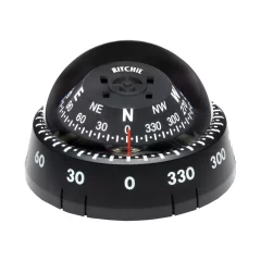
• CourseMinder Movable Bezel with Heading Memory Indicator Remembers the Way... so you don't have to
• 2 3/4' Direct-Reading Dial
• Low Mounted Height
• Surface Mount
• Easily Installed
• Extended Temperature Operating Range with Composite Construction & Diaphragm
• Exclusive DirectiveForce Magnets
• Hardened Steel Pivot and Sapphire Jewel Movement
• No Wiring or Power Needed
• Twist On/Off for Easy Removal for Security, Transport & Storage

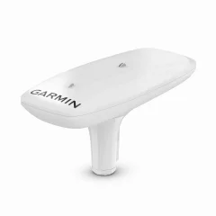
The easy-to-install GPS-based MSC™ 10 Marine satellite compass provides reliable, accurate heading information.
- Get accurate information easily when your boat is equipped with a multi-band GNSS receiver.
- Faster updates. More detailed tracking.
- Are you worried about rough seas? MSC 10 also provides pitch, roll and heave information
- The device is also suitable as a direction sensor for other boat systems.
MULTI-BAND GNSS AND MULTIPLE SATELLITE SYSTEMS
The receiver features multi-band GNSS (L1 and L5 GPS) and supports multiple satellite systems (GPS, Galileo, GLONASS and BeiDou), providing accurate positioning (<1 meter CEP, <3 meters 95%)
SHIP POSITION INFORMATION
You get reliable, accurate information about the boat's pitch, roll and heave, even in rough seas.
SHIP'S POSITION DATA - INTERNAL AHRS (ATTITUDE HEADING REFERENCE SYSTEM)
Internal AHRS provides better GPS heading information at high speeds.
ACCURATE DIRECTIONS
The multi-receiver system provides direction with an accuracy of 2 degrees. There is no need to worry about magnetic interference because the system uses satellite signals.
PRIMARY SENSOR IN MULTIPLE SYSTEMS
The MSC 10 compass can be used as a primary sensor for autopilots and other boat systems that require accurate heading information.
NMEA 2000® NETWORK SUPPORT
Receive heading, angle, roll and elevation data directly to your compatible Garmin chartplotter via the NMEA 2000 network.
EASY TO INSTALL
The compact device is easy to install and integrate into your boat's Garmin hardware system.
REFRESH RATE 10 HZ
With a 10Hz location update rate, you get better, more detailed tracking information.
SPARE HEADING SENSOR
In the rare event of a satellite signal loss, the MSC 10 seamlessly converts from a GPS-based to a magnetometer-based heading sensor. Magnetic heading support requires magnetometer calibration.
- Dimensions (W x D x H): 155.5 x 333.6 x 76.2 mm
- Weight: 810g
- Cable length: 6 m
- Temperature: -15°C to 70°C
- Housing material: adhesive-sealed, durable plastic alloy, waterproof (IPX7)
- Compass safety distance: 0 mm (0?)
- Power supply input: 9–32 Vdc, unregulated
- Input current: 180 mA (12 Vdc)
- NMEA 2000 -LEN (Load Equivalency Number): 6 (up to 300 mA)
- Location accuracy, typical boating use: <1 meter CEP, <3 meters 95%
- Heading accuracy: 2° RMS
- Elevation data accuracy: 8 cm RMS
IN THE PACKAGE:
- MSC™ 10 Marine Satellite Compass
- Pole mounting
- Fastening accessories
- NMEA 2000® backbone/device cable (6 m)
- NMEA 2000 T-connector
- Guides