C-MAP Discover X T-050 Chart, North and Central Europe

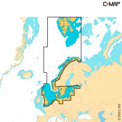
- Finland, Sweden, Norway and the Baltic Sea
- Compatible only with Simrad NSX, NSS 4 and B&G Zeus S, SR series devices
- MicroSD card 16GB (SD adapter included)
- Free map updates for 12 months
C-MAP DISCOVER X offers a completely new, dynamic charting experience. You have access to the latest vector data, state-of-the-art day and night modes and the most accurate C-MAP High-Res Bathymetry basemap. Newly introduced is the Map Inspector tool, which displays the most important information quickly and clearly. DISCOVER X integrates seamlessly with the Simrad Companion App. Versatile features such as customizable depth shading, tide and current information, subscription-free autorouting and 12 months of free online updates make navigation easier and safer.
Next Generation Charts
A next-generation mapping experience that makes navigation clearer than ever.
Optimized map data and a new presentation method provide the best possible overview on the water.
You always see the information you need without unnecessary clutter, at all zoom levels.
Excellent day and night modes ensure easy and safe use in all weather conditions, regardless of the time of day.
Smooth App Integration
Seamless integration with the Simrad Companion App.
You can plan routes, view journeys, and create waypoints in the app and sync them directly to your NSX device.
You can also access NSX device guides, instructions, and other materials directly from the app.
The future is connected navigation, and C-MAP and Simrad keep you ready for it.
The Best of C-MAP
The latest map data provides everything you need to navigate the water.
High-quality vector maps are based on official hydrographic data and make navigation accurate and reliable.
High-Res Bathymetry shows shallows, ledges, mounds and other bottom features with up to 1 foot accuracy.
Subscription-free autorouting automatically calculates the shortest and safest route based on map data and boat settings.
Customizable depth shading helps highlight desired depths and makes fishing even more efficient.
Detailed port and approach information brings confidence when entering new ports and waterways.
New Map Inspector Tool
The new Map Inspector feature displays the information you need quickly and with one tap.
Tide and current information makes it easier to plan your day.
Accurate port maps include floor plans, berth locations, restricted areas and other important information for thousands of ports.
Includes 12 months of free map updates.
Key features:
Next Generation Charts
Smooth App Integration
Map Inspector Tool
Large vector maps
High-Res Bathymetry
Customizable depth shading
State-of-the-art day and night modes
Tide and current information
Detailed port maps
Approach and port information
Subscription-free autorouting
12 months of free updates
Ready for the connected future
Tuotenr: M-EN-T-050-D-MS
Suosittelemme sinulle


