Tuoteryhmät
Garmin GPSMAP 1623XSV chartplotter
-20%
-20%
-20%
-20%
-20%
-20%


- Screen size: 16"
- Touchscreen
- Sonar must be purchased separately
- Easily integrates with multiple engines.
- With our top-notch network connections, you can easily expand your boating system.
- Support for Garmin Navionics+™ and premium Garmin Navionics Vision+™ charts
- Built-in sonar capabilities let you see below your boat (xsv models only).
- Control your boating almost anywhere.
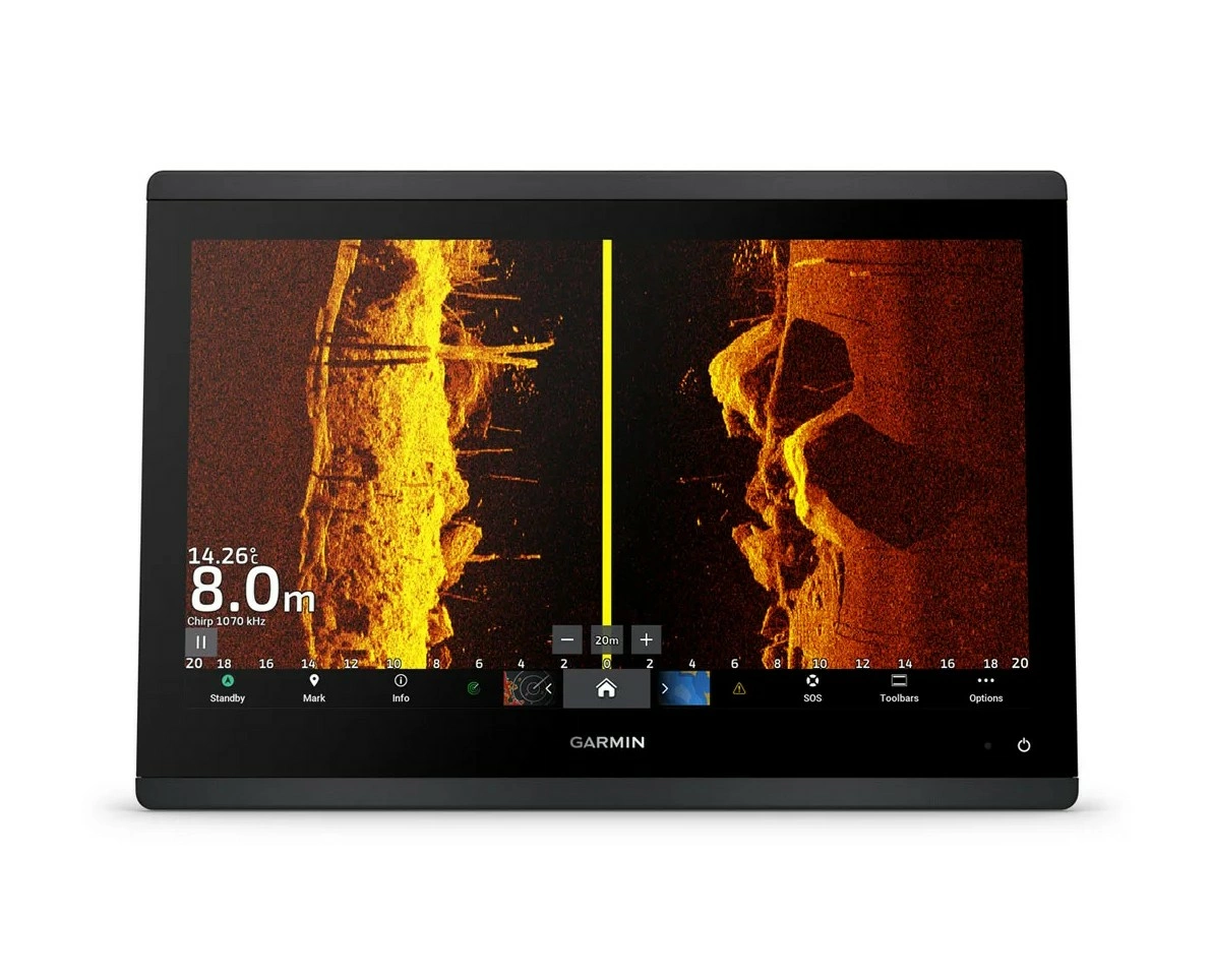
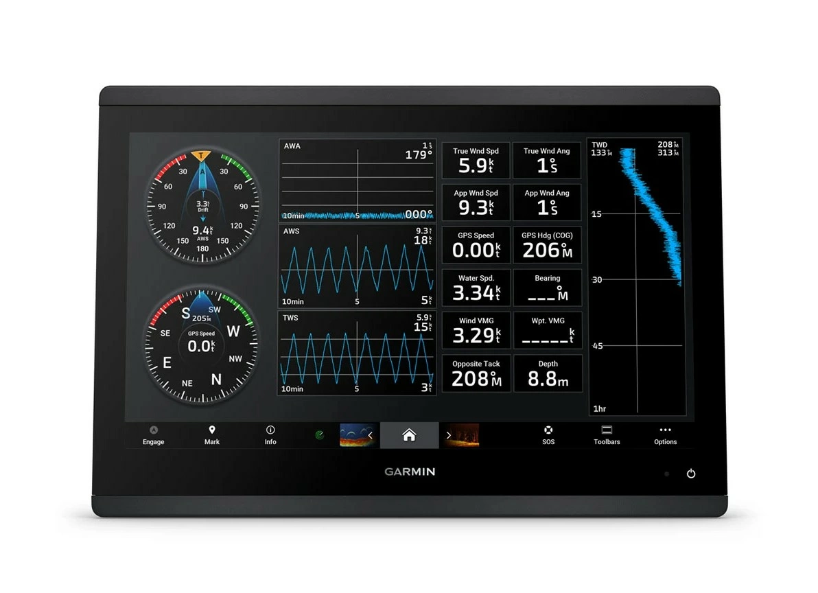
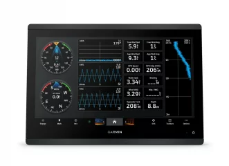
High-precision scanning sonar
Get built-in, high-resolution scanning SideVü™ and ClearVü™ sonar with vibrant, high-contrast colors that help you distinguish fish from structure. Plus, the GPSMAP X3 chartplotter family supports traditional 1 kW sonar functionality. Compatible with sonar on XSV models only.
Garmin SailAssist™ sailing features
View laylines, race start line markers, enhanced wind rose, heading and bearing line to bottom, true wind data fields, tide/current/time slider, wind angle, current direction and speed, and wind speed.
PANOPTIX™ sonar support
Pair with Panoptix™ sonar or easy-to-interpret, real-time LiveScope™ sonar (requires transducer, sold separately) to see all around your boat in real time.
Sailing poles
Check the polar chart for important information, such as required speeds at specific wind angles and speeds, to know if the sail needs adjusting.
Faster, sharper and smarter
With added processing power, a streamlined design, and a borderless glass display, this plotter is easy to install on a wide variety of dashboards.
Garmin Marine Network
If you have multiple compatible Garmin devices on your boat, you can share data, such as maps, user data, radar and IP camera video, between them.
Bright and clear optics
The high-resolution IPS displays on the 9'', 12'' and 16'' chartplotters are more readable in sunlight and from all viewing angles.
NMEA 2000® and NMEA 0183 networks
Connect to compatible autopilots, digital connections, weather services, Fusion audio systems, media files, VHF radio and AIS devices on the same screen.
Shallow Water POWER-POLE® Anchor
When you connect Garmin chartplotters to a Force® trolling motor and compatible shallow water Power-Pole anchor system over the network, your chartplotter gets advanced boat management features3, including smart anchor auto-calculation, smart anchor transfer, auto-retract, anchor drag detection and auto-guided2 anchoring at the end of the route. Focus on fishing, not finding your position.
ActiveCaptain® App
Connect to the free, comprehensive mobile app with built-in Wi-Fi®, including OneChart™, smart notifications, software updates, Helm app and Garmin Quickdraw™ online community1.
PowerPole charging integration
The Power-Pole CHARGE Marine Power Manager integrates with compatible Garmin chartplotters to help keep your battery running longer and stronger on the water. You can charge batteries while you're on the move, monitor power usage, select power destinations, manage emergency starts, and even transfer power between backup power sources right from your chartplotter screen.
Integrated ANT® technology
Connect to your favorite devices, including quatix® marine watches, gWind™ Wireless 2 wind sensors, GNX™ Wind marine devices, and wireless remote controls.
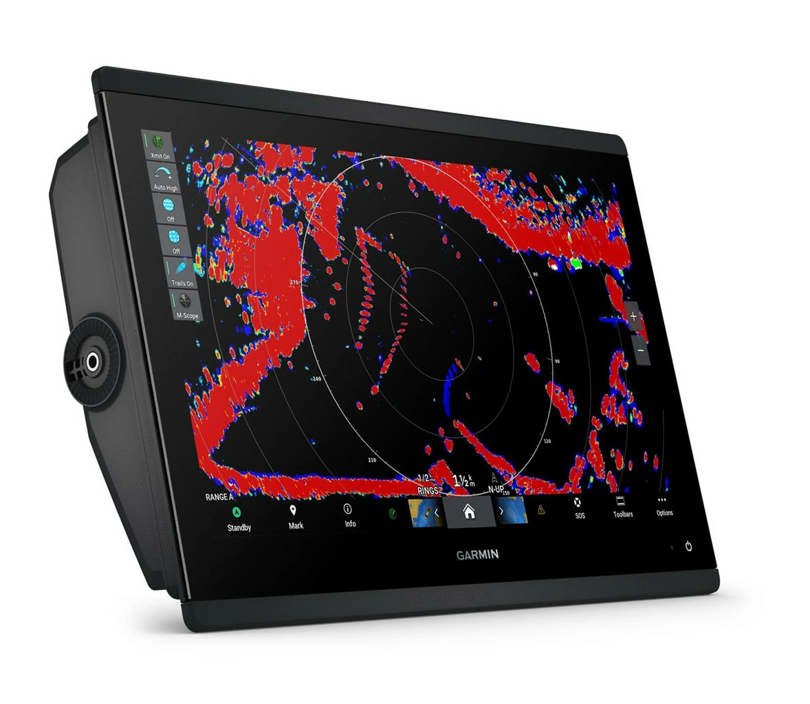
Optional radar package
When you want to avoid bad weather and traffic on the water, the compact 4 kW GMR™ 18 HD3 dome radar is available as an option in the GPSMAP chartplotter/sounder package. and much more.
OneHelm feature
This feature combines the functions and features of certain third-party devices, such as EmpirBus™ digital connectivity, into the same display.
Trolling motor integration
By purchasing support and integration for the Force trolling motor (sold separately), you can ensure full control while fishing.
Motor connection
The chartplotter can be connected to a variety of engines, including certain Yamaha® engines.
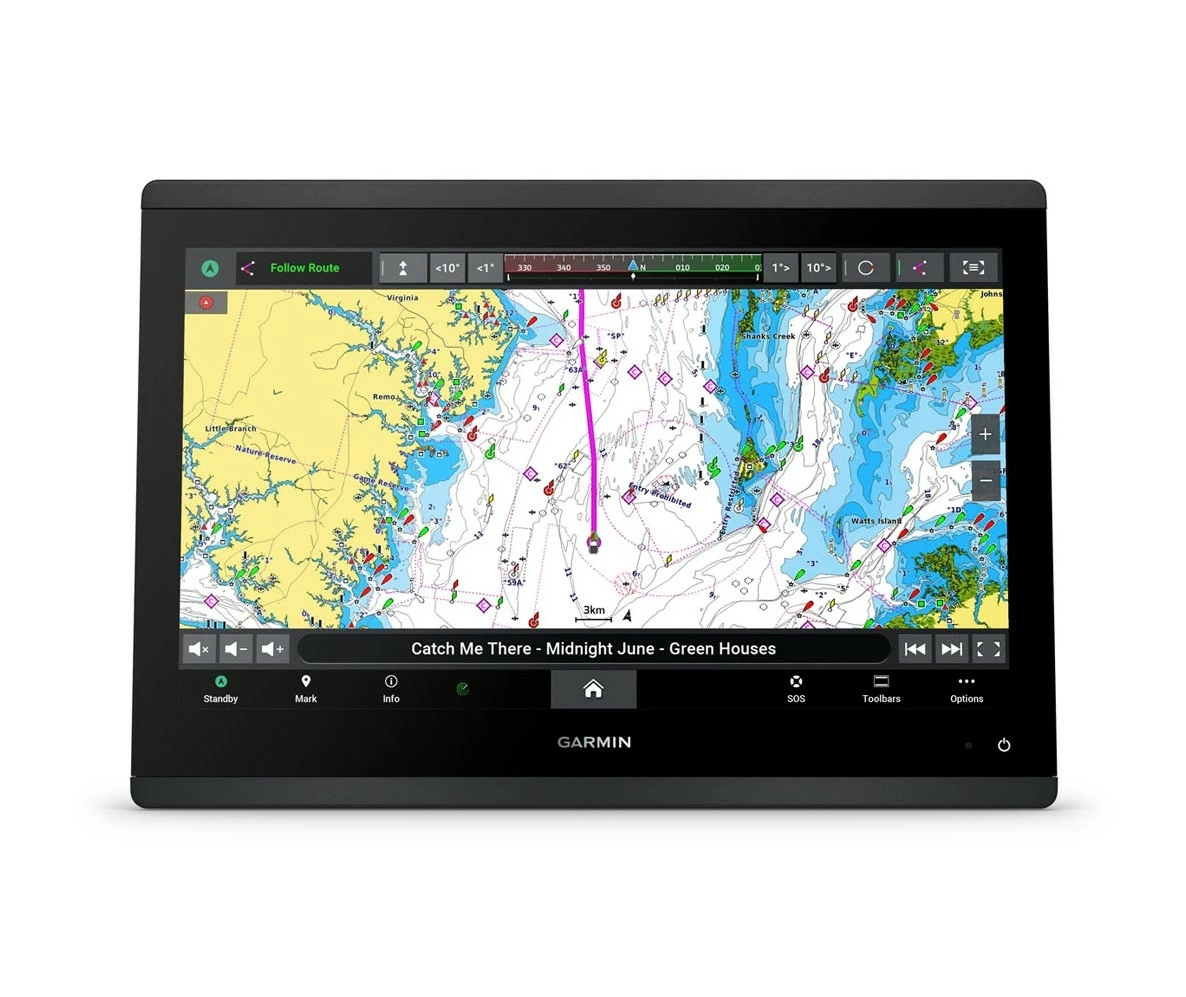
Map cards
Upgrade your chartplotter with optional Garmin Navionics+™ or Garmin Navionics Vision+™ premium charts, including coastal/inland content, daily updates and Auto Guidance+™ technology1.
Send messages on your InReach® device
Pair your inReach satellite communicator4 with your chartplotter and type your own messages using the MFD’s on-screen keyboard. Use your contact list or add an email address, inReach address or phone number. You can also group messages by conversation, just like text messages.
Specifications
- Dimensions: 38.4 x 26.2 x 7.6 cm (15.1'' x 10.3'' x 3.0'')
- Weight: 4.4 kg
- Waterproof rating: IPX7
- Touchscreen: yes
- Display type: FHD, IPS
- Screen size: 34.5 x 19.5 cm; diagonal 39.7 cm (13.6'' x 7.7''; diagonal 15.6'')
- Screen resolution: 1920 x 1080 pixels
- Mounting options: Surface, flush, or flush mount (Garmin does not offer accessories or parts for flush or flush mounting. Professional tools and expertise are required.)
Maps and memory
- Supports memory cards: 2 microSD cards (card slot on the back of the device)
- Waypoints: 5000
- Posting points: 50,000
- Tracks: 50 saved tracks
- Routes: 100
- Sensors: Yes
- GPS: Yes
- GLONASS: Yes
- Galileo: Yes
- Internal receiver: Yes
- Receiver: 10 Hz
- NMEA 2000® compatible: Yes
- NMEA 0183 compatible: Yes
- WAAS support: Yes
- Tide tables: Yes
Optional map support
- BlueChart g3: Yes
- BlueChart g3 Vision: Yes
- LakeVü g3: Yes
- LakeVü g3 Ultra: Yes
- Garmin Navionics+™: Yes
- Garmin Navionics Vision+™: Yes
- TOPO 100K: Yes
- Standard maps: Yes
- Garmin Quickdraw Contours: Yes
- Raster map support: Yes
Chartplotter functions
- Garmin SmartMode compatible (customizable display presets): Yes
- AIS compatible (ability to track the location of a target vessel). Yes
- DSC-compatible (displays position information reported by a DSC-compatible VHF radio): Yes
- Supports FUSION-Link™ compatible radios: Yes
- GSD™ Black Box sonar support: Yes
- GCV™ Black Box sonar support: Yes
- ActiveCaptain compatible: yes
- GRID™ (Garmin Remote Input Device) compatible: Yes
- Wireless remote control compatible: Yes
- Sailing features: Yes
- Spoken audio alarms: Yes
- OneHelm™ support: Yes
Electrical information
- Power input: 10–32 Vdc
- Typical current consumption: (12 V dc) 2.90 A
- Maximum current consumption: (12 V dc) 3.73 A
- Maximum power consumption: (10 V dc) 46.0W
Sonar functions and specifications
- Displays sonar: Yes
- Traditional Sonar: Internal (single channel CHIRP, 50/70/83/200 kHz, L, M, H CHIRP)
- ClearVü: Yes Internal 260/455/800/1000/1200 kHz
- SideVü: Yes Internal 260/455/800/1000/1200 kHz
- Panoptix™ sonar: Yes
- LiveScope: Yes
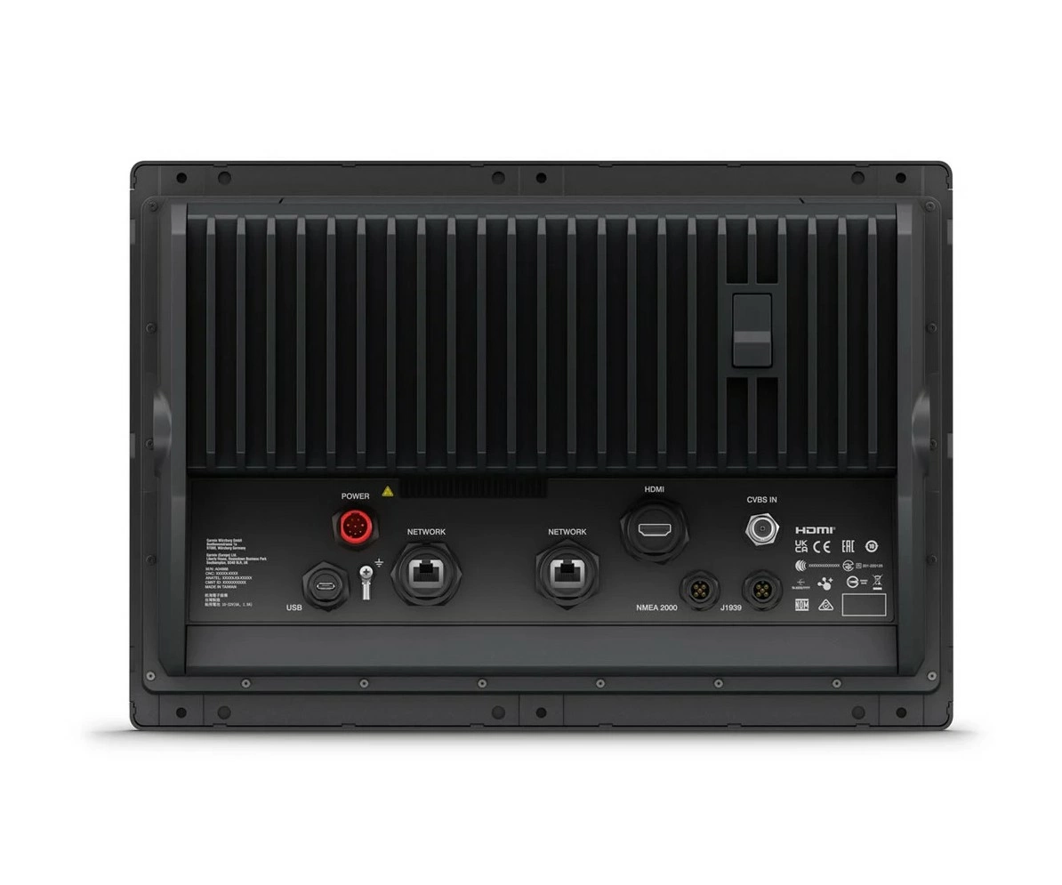
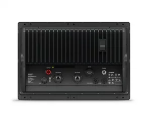
Connections
- NMEA 2000® ports: 1
- NMEA 0183 input ports: 1
- NMEA 0183 output ports: 1
- Video inputs: 1 (BNC composite)
- Video output ports: 1 HDMI
- J1939 ports: 1
- Garmin Marine Network™ ports: 2
- USB ports: Yes
- Bluetooth® calling: Yes
- ANT+™ (connection): Yes
- Garmin Wi-Fi® Network (Local Area Connection): Yes
Tuotenr: 13359
Valmistajan tuotenr: 010-02919-02
Kampanjahinta
4789,00 €5962,00 €/ pc(s)
Yhteensä sis. alv 25.5%
Helsinki LauttasaariNot currently available
Vantaa PorttipuistoNot currently available
VerkkokauppaAvailable on orderdelivery time 3 - 6 working days
Toimituksen hinta: 5,90 €Matkahuolto's Near Parcel
- Screen size: 16"
- Touchscreen
- Sonar must be purchased separately
- Easily integrates with multiple engines.
- With our top-notch network connections, you can easily expand your boating system.
- Support for Garmin Navionics+™ and premium Garmin Navionics Vision+™ charts
- Built-in sonar capabilities let you see below your boat (xsv models only).
- Control your boating almost anywhere.
High-precision scanning sonar
Get built-in, high-resolution scanning SideVü™ and ClearVü™ sonar with vibrant, high-contrast colors that help you distinguish fish from structure. Plus, the GPSMAP X3 chartplotter family supports traditional 1 kW sonar functionality. Compatible with sonar on XSV models only.
Garmin SailAssist™ sailing features
View laylines, race start line markers, enhanced wind rose, heading and bearing line to bottom, true wind data fields, tide/current/time slider, wind angle, current direction and speed, and wind speed.
PANOPTIX™ sonar support
Pair with Panoptix™ sonar or easy-to-interpret, real-time LiveScope™ sonar (requires transducer, sold separately) to see all around your boat in real time.
Sailing poles
Check the polar chart for important information, such as required speeds at specific wind angles and speeds, to know if the sail needs adjusting.
Faster, sharper and smarter
With added processing power, a streamlined design, and a borderless glass display, this plotter is easy to install on a wide variety of dashboards.
Garmin Marine Network
If you have multiple compatible Garmin devices on your boat, you can share data, such as maps, user data, radar and IP camera video, between them.
Bright and clear optics
The high-resolution IPS displays on the 9'', 12'' and 16'' chartplotters are more readable in sunlight and from all viewing angles.
NMEA 2000® and NMEA 0183 networks
Connect to compatible autopilots, digital connections, weather services, Fusion audio systems, media files, VHF radio and AIS devices on the same screen.
Shallow Water POWER-POLE® Anchor
When you connect Garmin chartplotters to a Force® trolling motor and compatible shallow water Power-Pole anchor system over the network, your chartplotter gets advanced boat management features3, including smart anchor auto-calculation, smart anchor transfer, auto-retract, anchor drag detection and auto-guided2 anchoring at the end of the route. Focus on fishing, not finding your position.
ActiveCaptain® App
Connect to the free, comprehensive mobile app with built-in Wi-Fi®, including OneChart™, smart notifications, software updates, Helm app and Garmin Quickdraw™ online community1.
PowerPole charging integration
The Power-Pole CHARGE Marine Power Manager integrates with compatible Garmin chartplotters to help keep your battery running longer and stronger on the water. You can charge batteries while you're on the move, monitor power usage, select power destinations, manage emergency starts, and even transfer power between backup power sources right from your chartplotter screen.
Integrated ANT® technology
Connect to your favorite devices, including quatix® marine watches, gWind™ Wireless 2 wind sensors, GNX™ Wind marine devices, and wireless remote controls.
Optional radar package
When you want to avoid bad weather and traffic on the water, the compact 4 kW GMR™ 18 HD3 dome radar is available as an option in the GPSMAP chartplotter/sounder package. and much more.
OneHelm feature
This feature combines the functions and features of certain third-party devices, such as EmpirBus™ digital connectivity, into the same display.
Trolling motor integration
By purchasing support and integration for the Force trolling motor (sold separately), you can ensure full control while fishing.
Motor connection
The chartplotter can be connected to a variety of engines, including certain Yamaha® engines.
Map cards
Upgrade your chartplotter with optional Garmin Navionics+™ or Garmin Navionics Vision+™ premium charts, including coastal/inland content, daily updates and Auto Guidance+™ technology1.
Send messages on your InReach® device
Pair your inReach satellite communicator4 with your chartplotter and type your own messages using the MFD’s on-screen keyboard. Use your contact list or add an email address, inReach address or phone number. You can also group messages by conversation, just like text messages.
Specifications
- Dimensions: 38.4 x 26.2 x 7.6 cm (15.1'' x 10.3'' x 3.0'')
- Weight: 4.4 kg
- Waterproof rating: IPX7
- Touchscreen: yes
- Display type: FHD, IPS
- Screen size: 34.5 x 19.5 cm; diagonal 39.7 cm (13.6'' x 7.7''; diagonal 15.6'')
- Screen resolution: 1920 x 1080 pixels
- Mounting options: Surface, flush, or flush mount (Garmin does not offer accessories or parts for flush or flush mounting. Professional tools and expertise are required.)
Maps and memory
- Supports memory cards: 2 microSD cards (card slot on the back of the device)
- Waypoints: 5000
- Posting points: 50,000
- Tracks: 50 saved tracks
- Routes: 100
- Sensors: Yes
- GPS: Yes
- GLONASS: Yes
- Galileo: Yes
- Internal receiver: Yes
- Receiver: 10 Hz
- NMEA 2000® compatible: Yes
- NMEA 0183 compatible: Yes
- WAAS support: Yes
- Tide tables: Yes
Optional map support
- BlueChart g3: Yes
- BlueChart g3 Vision: Yes
- LakeVü g3: Yes
- LakeVü g3 Ultra: Yes
- Garmin Navionics+™: Yes
- Garmin Navionics Vision+™: Yes
- TOPO 100K: Yes
- Standard maps: Yes
- Garmin Quickdraw Contours: Yes
- Raster map support: Yes
Chartplotter functions
- Garmin SmartMode compatible (customizable display presets): Yes
- AIS compatible (ability to track the location of a target vessel). Yes
- DSC-compatible (displays position information reported by a DSC-compatible VHF radio): Yes
- Supports FUSION-Link™ compatible radios: Yes
- GSD™ Black Box sonar support: Yes
- GCV™ Black Box sonar support: Yes
- ActiveCaptain compatible: yes
- GRID™ (Garmin Remote Input Device) compatible: Yes
- Wireless remote control compatible: Yes
- Sailing features: Yes
- Spoken audio alarms: Yes
- OneHelm™ support: Yes
Electrical information
- Power input: 10–32 Vdc
- Typical current consumption: (12 V dc) 2.90 A
- Maximum current consumption: (12 V dc) 3.73 A
- Maximum power consumption: (10 V dc) 46.0W
Sonar functions and specifications
- Displays sonar: Yes
- Traditional Sonar: Internal (single channel CHIRP, 50/70/83/200 kHz, L, M, H CHIRP)
- ClearVü: Yes Internal 260/455/800/1000/1200 kHz
- SideVü: Yes Internal 260/455/800/1000/1200 kHz
- Panoptix™ sonar: Yes
- LiveScope: Yes
Connections
- NMEA 2000® ports: 1
- NMEA 0183 input ports: 1
- NMEA 0183 output ports: 1
- Video inputs: 1 (BNC composite)
- Video output ports: 1 HDMI
- J1939 ports: 1
- Garmin Marine Network™ ports: 2
- USB ports: Yes
- Bluetooth® calling: Yes
- ANT+™ (connection): Yes
- Garmin Wi-Fi® Network (Local Area Connection): Yes
Tuotenr: 13359
Valmistajan tuotenr: 010-02919-02
Katso muut tuotemerkin tuotteet

Suosittelemme sinulle
Maksutavat


