Garmin
Garmin -ryhmän tuotteet
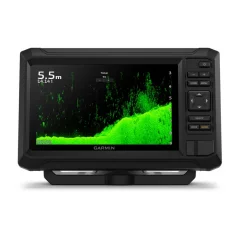
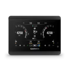
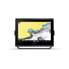
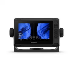
7" chartplotter with keypad control and sonar option
With sharp, clear traditional sonar and bright ClearVü sonar, fish can’t escape. High-contrast, vibrant scanning sonar color palettes make it easy to distinguish targets and structure. The Garmin ECHOMAP UHD2 device supports multiple Garmin transducers for two types of sonar: Garmin traditional sonar and ClearVü scanning sonar.
With optional Garmin Navionics+™ and Garmin Navionics Vision+™ marine charts, you know the waters like the back of your hand.
If you have another compatible ECHOMAP UHD2 chartplotter on your boat , the 5" and 7" models can wirelessly share data like sonar, waypoints, and routes with them.
Connect to free, comprehensive ActiveCaptain via built-in Wi-Fi for features like OneChart™, software updates, and Garmin Quickdraw™ community information2.
Specifications
- Dimensions: 23.2 x 14.3 x 6.7 cm
- Button operation: Button operated
- Screen size: 15.5 x 8.7 cm
- Screen resolution: 800 x 480 pixels
- Display type: WVGA, TN
- Weight: 0.7 kg
- Water rating: IPX7
- Mounting options: Mounting or recessed
- Supports memory cards: 1 microSD™ card; size up to 32 GB
- Waypoints: 5000
- Posting points: 50000
- Tracks: 50 saved tracks
- Routes: 100
- Internal GPS receiver: Yes
- Displays sonar: Yes
- Power: 500W
- Traditional Sonar (Dual Frequency/Beam): Internal (Single Channel CHIRP, 70/83/200 kHz, L, M, H CHIRP)
- ClearVü: Internal 260/455/800 kHz
In the package
- ECHOMAP UHD2
- Power cord/data cable
- Tiltable mount
- Flush mounting
- Hardware
- Guides
- Screen size: 7"
- No touchscreen
- Sonar must be purchased separately
- Bright button-operated display
- You get two views1: Garmin's traditional CHIRP sonar and ClearVü scanning sonar.
- Underwater subjects look even better with high-contrast, vibrant color palettes.
- Sharing data between compatible chartplotters is easy with Wi-Fi® connectivity.
- Enjoy the best maps:3 Garmin Navionics+ and Garmin Navionics Vision+
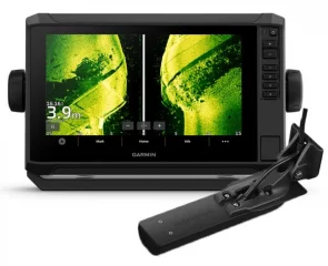
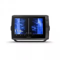
9' chartplotter with touchscreen and sonar transducer. With sharp, clear traditional sonar and bright ClearVü and SideVü scanning sonar, fish can’t escape. In addition, ECHOMAP UHD2 supports LiveScope™ real-time scanning sonar. The bright, clear colors of scanning sonar make it easy to distinguish targets and structure. The ECHOMAP UHD2 supports a wide range of Garmin transducers and is networkable with other Garmin devices.
- Screen size: 9'
- Touchscreen and buttons
- Includes GT56 transducer
- A transom sensor with an oblique sonar is included.
- Three types of sonar: Garmin traditional sonar, ClearVü™ and SideVü™ sonar.
- If you use another ECHOMAP UHD2 chartplotter, you can share sonar, waypoints, and routes wirelessly.
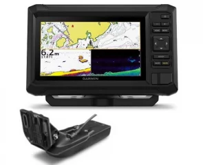
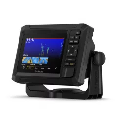
7' chartplotter/sounder with buttons and GT20 transom sensor. With sharp, clear traditional sonar and bright ClearVü sonar, fish can’t escape. High-contrast, vibrant scanning sonar color palettes make it easy to distinguish targets and structure. ECHOMAP UHD2 supports multiple Garmin transducers for two types of sonar: Garmin traditional sonar and ClearVü scanning sonar.
- Screen size: 7'
- No touchscreen
- Includes GT20-TM transducer
- Accurate ClearVü sonar (includes GT-20 transom sensor)
- The bright button-operated display or 7' is designed with convenience first
- You get two views1: Garmin's traditional CHIRP sonar and ClearVü scanning sonar.
- Underwater subjects look even better with high-contrast, vibrant color palettes.
- Sharing data between compatible chartplotters is easy with Wi-Fi® connectivity.
- Enjoy the best maps: Garmin Navionics+ and Garmin Navionics Vision+.
9" touchscreen and optional side-scan sonar. No transducer included. Can be linked to a variety of Garmin devices. With sharp, clear traditional sonar images and bright ClearVü and SideVü scanning sonar images, fish can't escape. In addition, the ECHOMAP UHD2 supports LiveScope™ real-time scanning sonar. The bright, clear colors of the scanning sonar make it easy to distinguish targets and structure. The ECHOMAP UHD2 device supports a wide range of Garmin sonar transducers.
Experience unprecedented coverage and detail with optional Garmin Navionics+ charts or optional Garmin Navionics Vision Premium charts, featuring features like accurate elevation shading, satellite and sonar imagery, and includes a 1-year subscription of downloadable daily updates.
If you have another compatible ECHOMAP UHD2 chartplotter on your boat, you can wirelessly share data like sonar, waypoints, and routes with it.
Connect to the free, comprehensive mobile app via built-in Wi-Fi® for features like OneChart™, smart notifications, software updates, Garmin QuickDraw community insights2.
Chartplotters with built-in Garmin Navionics+ charts include Auto Guidance+ technology3, which is available for download using the ActiveCaptain app.
The ECHOMAP UHD2 chartplotter can connect wirelessly to a Force trolling motor for features like creating and following routes, navigating to waypoints, controlling speed, and checking battery life.
Multi-band GPS gives you even more accurate location, especially in areas where signals are reflected or weak.
Specifications
- Dimensions: 26.4 x 16.6 x 8 cm
- Touchscreen: Yes
- Button operation: Touch screen and button operation
- Screen size: 19.8 x 11.5 cm, 22.9 cm
- Screen resolution: LXK: 1024 x 600 pixels
- Display type: WSVGA, TN
- Weight: 1.3 kg
- Water rating: IPX7
- Mounting options: Mounting or recessed
- Supports memory cards: 1 microSD™ card; size up to 32 GB
- Waypoints: 5,000
- Posting points: 50,000
- Tracks: 50 saved tracks
- Routes: 100
- Internal receiver: Yes
- Receiver: Yes
- NMEA 2000® compatible: Yes
- Supports FUSION-LINK™ compatible radios: Yes
- ActiveCaptain compatible: Yes
- Sailing features: Yes
- Displays sonar: Yes (when transducer installed; sold separately)
- Power: 500W
- Traditional Sonar: Internal (single channel CHIRP, 50/77/83/200 kHz, L, M, H CHIRP)
- CLEARVÜ: built-in 260/455/800/1000/1200 kHz
- SIDEVÜ: built-in 260/455/800/1000/1200 kHz
- PANOPTIX™ SONAR: Option
- LIVESCOPE: Option
Included in the package
- ECHOMAP UHD2 (device varies by selection)
- 12-pin sonar to 8-pin transducer adapter cable
- Power cord
- Tilt stand with quick-attach dock
- Protective cover
- Hardware
- Guides
- Screen size: 9"
- Touchscreen and buttons
- Sonar must be purchased separately
- Possibility to connect a transducer (sold separately)
- Surface and flush mountable
- Internal GPS receiver
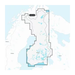
Garmin Navionics+ NSEU055R
Detailed information on Finnish lakes, including Inarijärvi, Miekojärvi, Simojärvi and Kiantajärvi. Also includes detailed information on Oulujärvi, Pielinen, Saimaa, Päijänne, Näsijärvi, Lohjanjärvi, Nuorajärvi, Kilpisjärvi and other lakes.
Check map compatibility here or with customer service.
Comprehensive mapping solution for Garmin chartplotters
Daily map updates
Auto guidance+ technology
Depth of field shading
Curves up to 0.5m apart
Shallow water shading
Active captain community
EU050R chart card. Garmin Navionics+ charts feature vibrant colors, a streamlined interface, combined coastal/inland content, and the popular Navionics®-style color palette, allowing you to easily plan your route with the most popular marine chart provider on the market.
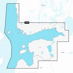
Garmin Navionics+ NSEU050R
Detailed information on the Gulf of Finland from Åland to St. Petersburg (Russia), including the Gulf of Riga, Lake Peipsi and Narva River. The information covers the ports of Turku, Helsinki and Kotka (Finland), Vyborg, Kronstadt and Lomonosov (Russia), Tallinn (Estonia) and Riga and Ventspils (Latvia).
You can access the map material here .
Check map compatibility here or with customer service.
Comprehensive mapping solution for Garmin chartplotters
Daily map updates
Auto guidance+ technology
Depth of field shading
Curves up to 0.5m apart
Shallow water shading
Active captain community
Stylish 9-inch multifunction display with high-precision scanning sonar
Excellent performance and an updated IPS display, seamlessly integrates with your Garmin marine system.
- Easily integrates with multiple engines.
- Connect to compatible third-party devices with OneHelm™ digital connectivity.
- With top-notch network connectivity, you can easily expand your boating system.
- Compatible with Garmin's best navigation maps1.
- Built-in sonar capabilities let you see below your boat
- High-precision scanning sonar
Panoptix and Livescope sonar support
Pair with easy-to-interpret real-time Panoptix or Livescope sonar (requires transducer, sold separately) to see your boat’s entire surroundings in real time.
Faster, sharper, smarter multifunction display
With improved processing power, a new streamlined shape, a borderless glass display, and a small footprint, this chartplotter is easy to retrofit into a wide variety of cockpits and boats.
Improved display optics
GPSMAP 9-inch and 12-inch chartplotters feature new, higher-resolution IPS displays for improved sunlight readability and visibility from all angles. They feature 50% more pixels than the previous generation of 9-inch GPSMAPs.
Garmin Marine Network
If you have multiple Garmin devices on your boat, you can share data, such as maps, user data, sonar, and IP cameras, between them.
NMEA2000 and NMEA0183 networks
Connect to autopilots, digital connections, weather services, FUSION-Link™ audio systems, media files, VHF radio and AIS devices on the same screen.
Integrated ANT technology
Connect to your favorite devices, including quatix marine watches, gWind 2 wireless transducers and gWind transducers, marine devices and wireless remote controls.
Motor connection
You can now connect your chartplotter to various engines, for example Yamaha engines.
Onehelm feature
This unique feature combines the functions and features of certain third-party devices, such as EmpirBus™ digital connectivity, into the same display.
Garmin Sailassist sailing features
View laylines, race start line markers, enhanced wind rose, heading and bearing to bottom, true wind data fields, tide/current/time slider, wind angle, current direction and speed, and wind speed.
Sailing poles
The polar chart lets you view important information, such as the required speeds at specific wind angles and speeds – so you know if you need to adjust your sail.
Send messages on Inreach devices
Pair your inReach satellite communicator5 with your chartplotter and type your own messages using the MFD’s on-screen keyboard. Use your contact list or add an email address, inReach address or phone number. You can also group messages by conversation, just like text messages.
Nautical charts and other maps
Upgrade your chartplotter with optional Garmin Navionics+™ or Garmin Navionics Vision+™ Premium charts, including coastal/inland content, daily updates and Auto Guidance+™ technology. Requires Garmin Active Captain app.
Active Captain app
Connect to the free, comprehensive ActiveCaptain app via built-in Wi-Fi® for features like OneChart™, smart notifications, software updates, and Garmin Helm™ digital connectivity.
Shallow Water Power Pole Anchor
When you connect Garmin chartplotters to a Force® trolling motor and compatible Power-Pole shallow water anchor system over the network, your chartplotter gets advanced boat management features6, including Smart Anchor Auto-Calc, Smart Anchor Shift, Auto-Retract, Anchor Drag Detection and Auto-Guided3 Anchoring at the End of the Route. Focus on fishing, not finding your way. Integration of these features requires purchase of C-Monster GATEWAY through Power-Pole
Power-Pole Charge integration
The Power-Pole CHARGE Marine Power Manager integrates with compatible Garmin chartplotters to help keep your battery running longer and stronger on the water. You can charge batteries while you're on the move, monitor power usage, select power destinations, manage emergency starts, and even transfer power between backup power sources right from your chartplotter screen.
- Screen size: 9'
- Touchscreen
- Sonar must be purchased separately
- Device dimensions: 23.3 x 16.2 x 7.6 cm
- Screen size: 19.9 x 11.2 cm
- Power input: 10 to 32 Vdc
- Maximum current consumption: 3.20A
- Typical current consumption (12 V dc): 1.37A
- Screen resolution, WxH: 1028 x 720 pixels
- Built-in GPS + GLONASS
- Highly sensitive receiver (10 Hz)
- Water rating: IPX7
- Weight: 1.6 kg
- Mounting options: Mounting, recessed or surface
- Display type: WXGA display
- Routes that can be saved: 100pcs
- Waypoints that can be saved: 5000pcs
- Automatic guidance: yes
- NMEA2000 and NMEA0183 compatible
- Supports memory cards: 2xMicroSD cards (on the back of the device)
- USB ports: yes
- Wireless remote control compatible: yes
- Video inputs: BNC 1pc
- Sailing characteristics
- DSC-compatible (displays position information reported by a DSC-compatible VHF radio): yes
- Supports FUSION-Link™ compatible radios
- AIS compatible (ability to track the location of a target vessel)
- OneHelm™ support
- BNC port for external antenna: No
Compatible maps:
- Garmin Navionics+
- Garmin Navionics Vision+
- Bluechart g3
- Bluechart g3 Vision
Sonar:
- 12-pin transducer ports: 1 pc
- Internal ClearVü: 260/455/800/1000/1200 kHz
- Internal SideVü Sonar: Internal 260/455/800/1000/1200 kHz
- Traditional sonar (dual frequency/beam): Internal (single channel CHIRP, 70/83/200 kHz, L, M, H CHIRP)
- Panoptix™ sonar support
- Livescope sonar support
Sleek 5" touchscreen
Easy integration
Small size and versatile installation
Matches the look of GPSMAP® series chartplotters
Easy plug-and-play installation
Flush and flush mounting options
Easy access to boat systems
Scalable technology
Intuitive user interface
Versatile mounting options
Durable construction
Package contents
- TD50
- Snap-on cover for trim section
- Protective cover
- NMEA 2000® network device cable
- T-connector for NMEA 2000 network
- Fastening accessories
- Guides
- Screen size: 5"
- Touchscreen
- Easy connectivity
- Dimensions: (H x W x D): 10.5 x 14.0 x 5.1 cm
- Weight: 328g
- Temperature range: -15°C to 55°C
- Compass safety distance: 20 cm
- Housing material: Fully encapsulated polycarbonate
- Lens material: Glass with anti-glare and anti-fingerprint coating
- Water resistance: IPX7
- Brightness: 1200 cd/m² (NIT)
- Power consumption: Maximum 5.9 W
- NMEA 2000® input voltage: 9-16 Vdc
- NMEA 2000 LEN (9 Vdc): 13 (650 mA)
The ECHOMAP UHD2 52cv is an easy-to-use 5' chartplotter
Design
User interface
Built-in Wi-Fi® connection
Nautical charts
VIVID sonar
Quickdraw Contours
ActiveCaptain® App
- Screen size: 5'
- No touchscreen
- Sonar must be purchased separately
The ECHOMAP UHD2 52cv is an easy-to-use 5" chartplotter
Design
User interface
Built-in Wi-Fi® connection
Nautical charts
VIVID sonar
Quickdraw Contours
ActiveCaptain® App
- Screen size: 5"
- No touchscreen
- Includes GT20-TM transducer
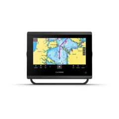
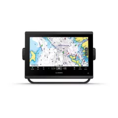
7' touchscreen without sonar
The Garmin GPSMAP 723 chartplotter is a versatile networkable chartplotter with other Garmin devices. With increased processing power, a new streamlined shape, a borderless glass display and a small size, this 7-inch chartplotter is easy to retrofit into a variety of dashboards. The high-resolution 7-inch display is easy to read even in sunlight. It has 60% more pixels than the previous generation of 7-inch GPSMAP devices.
View laylines, race start line markers, enhanced wind rose, heading and bearing line to bottom, true wind data fields, tide/current/time slider, wind angle, current direction and speed, and wind speed.3
These optional charts feature the best navigation data from Garmin and Navionics®, automatic guidance technology and other cutting-edge navigation features.
If you have multiple Garmin devices on your boat, you can share data, such as maps, user data, sonar, and IP cameras, between them.
Connect to autopilots, digital connections, weather services, FUSION-Link™ audio systems, media files, VHF radio and AIS devices on the same screen.
Connect to the free, comprehensive mobile app via built-in Wi-Fi® for features like OneChart™, smart notifications, software updates, Garmin Helm™ digital connectivity, Garmin Quickdraw™ online community information and more.5
Connect to your favorite devices, including quatix® marine watches, gWind™ 2 wireless transducers, GNX™ Wind marine gear, and wireless remote controls.
You can now also connect your chartplotter to a variety of engines, including Yamaha engines. This unique feature combines the functionality and features of select third-party devices, such as EmpirBus™ digital connectivity, onto the same display.
Specifications:
- Dimensions: 19.2 x 14.0 x 7.4 cm
- Touchscreen: Yes
- Button operation: Touchscreen
- Screen size: 15.4 x 9.1 cm, diagonal 17.8 cm
- Screen resolution: LXK: 1024 x 600 pixels
- Display type: WSVGA display
- Weight: 1.3 kg
- Water rating: IPX7
- Mounting options: Mounting, recessed or surface
- Screen size: 7'
- Touchscreen
- No sonar
- Sharp and highly accurate chartplotter with 60% more pixels
- Nearly double the performance of previous generation 7-inch GPSMAP devices.
- Easily integrates with multiple engines.
- Connect to compatible third-party devices with OneHelm digital connectivity.
- With top-notch network connectivity, you can easily expand your boating system.
- Compatible with Garmin's best navigation maps1.
- Clear laylines and other display information bring additional confidence to sailing.
Stylish 12-inch multifunction display with high-precision scanning sonar
Excellent performance and an updated IPS display, seamlessly integrates with your Garmin marine system.
Get built-in, high-resolution SideVü and ClearVü scanning sonar with vibrant, high-contrast colors that help you distinguish fish from structure. Plus, the GPSMAP® X3 series supports 1 kW traditional CHIRP sonar. Built-in sonar is available only on the xsv models.
Panoptix and Livescope sonar support
Pair with easy-to-interpret real-time Panoptix or Livescope sonar (requires transducer, sold separately) to see your boat’s entire surroundings in real time.
Faster, sharper, smarter multifunction display
With improved processing power, a new streamlined shape, a borderless glass display, and a small footprint, this chartplotter is easy to retrofit into a wide variety of cockpits and boats.
Improved display optics
GPSMAP 9-inch and 12-inch chartplotters feature new, higher-resolution IPS displays for improved sunlight readability and visibility from all angles. They feature 50% more pixels than the previous generation of 9-inch GPSMAPs.
Garmin Marine Network
If you have multiple Garmin devices on your boat, you can share data, such as maps, user data, sonar, and IP cameras, between them.
NMEA2000 and NMEA0183 networks
Connect to autopilots, digital connections, weather services, FUSION-Link™ audio systems, media files, VHF radio and AIS devices on the same screen.
Integrated ANT technology
Connect to your favorite devices, including quatix marine watches, gWind 2 wireless transducers and gWind transducers, marine devices and wireless remote controls.
Motor connection
You can now connect your chartplotter to various engines, for example Yamaha engines.
Onehelm feature
This unique feature combines the functions and features of certain third-party devices, such as EmpirBus™ digital connectivity, into the same display.
Garmin Sailassist sailing features
View laylines, race start line markers, enhanced wind rose, heading and bearing to bottom, true wind data fields, tide/current/time slider, wind angle, current direction and speed, and wind speed.
Sailing poles
The polar chart lets you view important information, such as the required speeds at specific wind angles and speeds – so you know if you need to adjust your sail.
Send messages on Inreach devices
Pair your inReach satellite communicator5 with your chartplotter and type your own messages using the MFD’s on-screen keyboard. Use your contact list or add an email address, inReach address, or phone number. You can also group messages by conversation, just like text messages.
Nautical charts and other maps
Upgrade your chartplotter with optional Garmin Navionics+™ or Garmin Navionics Vision+™ Premium charts, including coastal/inland content, daily updates and Auto Guidance+™ technology. Requires Garmin Active Captain app.
Active Captain app
Connect to the free, comprehensive ActiveCaptain app via built-in Wi-Fi® for features like OneChart™, smart notifications, software updates, and Garmin Helm™ digital connectivity.
Shallow Water Power Pole Anchor
When you connect Garmin chartplotters to a Force® trolling motor and compatible Power-Pole shallow water anchor system over the network, your chartplotter gets advanced boat management features6, including Smart Anchor Auto-Calc, Smart Anchor Shift, Auto-Retract, Anchor Drag Detection and Auto-Guided3 Anchoring at the End of the Route. Focus on fishing, not finding your way. Integration of these features requires purchase of C-Monster GATEWAY through Power-Pole
Power-Pole Charge integration
The Power-Pole CHARGE Marine Power Manager integrates with compatible Garmin chartplotters to help keep your battery running longer and stronger on the water. You can charge batteries while you're on the move, monitor power usage, select power destinations, manage emergency starts, and even transfer power between backup power sources right from your chartplotter screen.
- Screen size: 12'
- Touchscreen
- Sonar must be purchased separately
- Device dimensions: 30.8 x 22.8 x 8.2 cm
- Power input: 10 to 32 Vdc
- Maximum current consumption: 3.56A
- Typical current consumption (12 V dc): 1.68A
- Screen resolution, WxH: 1280 x 800 pixels
- Built-in GPS + GLONASS
- Highly sensitive receiver (10 Hz)
- Water rating: IPX7
- Weight: 3.0 kg
- Mounting options: Mounting, recessed or surface
- Display type: WXGA display
- Routes that can be saved: 100pcs
- Waypoints that can be saved: 5000pcs
- Automatic guidance: yes
- NMEA2000 and NMEA0183 compatible
- Supports memory cards: 2xMicroSD cards (on the back of the device)
- USB ports: yes
- Wireless remote control compatible: yes
- Video inputs: BNC 1pc
- Sailing characteristics
- DSC-compatible (displays position information reported by a DSC-compatible VHF radio): yes
- Supports FUSION-Link™ compatible radios
- AIS compatible (ability to track the location of a target vessel)
- OneHelm™ support
- BNC port for external antenna: No
Compatible maps:
- Garmin Navionics+
- Garmin Navionics Vision+
- Bluechart g3
- Bluechart g3 Vision
Sonar:
- 12-pin transducer ports: 1 pc
- Internal ClearVü: 260/455/800/1000/1200 kHz
- Internal SideVü Sonar: Internal 260/455/800/1000/1200 kHz
- Traditional sonar (dual frequency/beam): Internal (single channel CHIRP, 70/83/200 kHz, L, M, H CHIRP)
- Panoptix™ sonar support
- Livescope sonar support
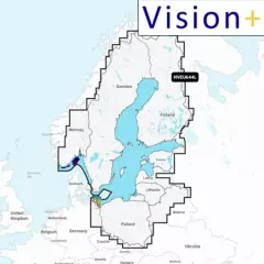
Garmin Navionics Vision+ NVEU644L
Detailed information on the Baltic Sea and the lakes of Scandinavia and Poland. The information covers the Gulf of Bothnia, the Gulf of Finland and the Gulf of Riga; the Masurian Lakes in Poland, Oderinhaffin, Lake Peipus; Mjøsa, Bandak and Norsjø in Norway; Vänern, Vättern, Siljan and Storavan in Sweden and Inarijärvi, Miekojärvi, Simojärvi and Kiantajärvi in ??Finland and many more. Includes the following ports: Oslo (Norway), Malmö and Stockholm (Sweden), Oulu and Helsinki (Finland), St. Petersburg and Kaliningrad (Russia) and Gdansk (Poland).
You can access the map material here .
Check map compatibility here or with customer service.
Vision+ additional features
Relief shading — better representation of the shape of the seabed and coastline, not just curves.
High-resolution satellite and aerial imagery of coastal areas and terrain — makes it easier to identify landmarks, ports, bridges, and other objects.
3D views: including 3D “fish-eye / marinereye” projection of underwater depths, where you can see the shapes of the bottom realistically.
Aerial photos / aerial photos of ports & port surroundings — makes it easier to land and visualize ports: harbors, piers, bridges, etc.
Ease of use and clearer visual appearance — colors, shading, and different view layers make reading the map more intuitive.
Comprehensive mapping solution for Garmin chartplotters
Get detailed maps that include coastlines, lakes, rivers, and more. Integrated Garmin and Navionics content helps boaters worldwide.
Daily map updates
The maps are constantly updated with new and changed content, with up to 5,000 updates per day. With the included one-year subscription, you get daily map updates via the ActiveCaptain app on your smart devices.
Auto guidance+ technology
Built-in Auto Guidance+ technology2 combines the best of Garmin and Navionics automatic routing features to suggest a route between marinas, including through canals, straits and marina entrances.
Depth of field shading
With precise depth range shading, you can select up to 10 color shading options and view defined target depths at a glance.
Curves up to 0.5m apart
The curves, drawn at intervals of up to 0.5 meters, make both fishing and navigation easier, showing the bottom contours clearly and in detail, for example in marshes, canals, harbors and marinas.
Shallow water shading
This function allows the user to define the depth of shading and thus avoid shallow water areas.
Active captain community
Community-contributed content provides useful points of interest, such as marinas, anchorages, obstacles, and businesses. Get recommendations from people with first-hand experience of the local environment.
Relief shading
Detailed shading3, which combines colors and shadows, shows the surface contours of the bottom more easily and clearly than simple curved lines.
Accurate satellite images
Downloadable high-resolution satellite imagery3 ensures excellent situational awareness.
Aerial photos
Ports, marinas, bridges, docks, boat ramps, dams and navigational landmarks are particularly clearly visible in aerial and surface imagery, improving situational awareness above the water surface.
3D Fisheye view
This underwater view shows the bottom and its contours in 3D from below the water surface. You can customize the view by adding sonar data.
3D Marine-eye view
In this view, the environment is shown in 3D from both above and below the water surface.
Lake level
In this view, the environment is shown in 3D from both above and below the water surface.
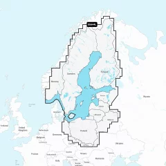
Chart Card NSEU644L. Garmin Navionics+ charts feature vibrant colors, a streamlined interface, and combined coastal/inland content, along with the popular Navionics®-style color palette. It lets you easily plan your route with the most popular marine chart provider on the market
Garmin Navionics+ NSEU644L
Detailed information on the Baltic Sea and the lakes of Scandinavia and Poland. The information covers the Gulf of Bothnia, the Gulf of Finland and the Gulf of Riga; the Masurian Lakes in Poland, Oderinhaffin, Lake Peipus; Mjøsa, Bandak and Norsjø in Norway; Vänern, Vättern, Siljan and Storavan in Sweden and Inarijärvi, Miekojärvi, Simojärvi and Kiantajärvi in ??Finland and many more. Includes the following ports: Oslo (Norway), Malmö and Stockholm (Sweden), Oulu and Helsinki (Finland), St. Petersburg and Kaliningrad (Russia) and Gdansk (Poland).
You can access the map material here .
Check map compatibility here or with customer service.
Comprehensive mapping solution for Garmin chartplotters
Daily map updates
Auto guidance+ technology
Depth of field shading
Curves up to 0.5m apart
Shallow water shading
Active captain community
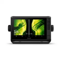
Versatile chartplotter and sonar with a large 10-inch touchscreen display that is clearly readable even in bright sunlight and includes a wealth of excellent fishing features. In addition to the touchscreen, the device has shortcut keys on the right bezel, meaning the device offers both options for use depending on the situation or user preferences. The device supports Garmin Navionics+™ and Garmin Navionics Vision+™ charts and the transducer adds highly accurate scanning sonar, as well as traditional CHIRP sonar. The device is therefore designed especially for fishermen and boaters who value accurate map information, advanced sounding and many compatibility options with other boat devices.
- Screen size: 10"
- Touchscreen and buttons
- Sonar must be purchased separately
- Dimensions: 29.5 x 19.5 x 9.8 cm
- Weight: 1.8 kg
- Waterproof rating: IPX7, which means the device can withstand immersion in water up to 1 meter deep for 30 minutes.
- Display type: WXGA, IPS, which offers wide viewing angles and good image quality.
- Screen size: 21.7 x 13.6 cm; diagonal 21.7 cm.
- Screen resolution: 1280 x 800 pixels.
- Mounting options: mounting bracket or flush mounting
- In addition, button operation, i.e. both touchscreen and button operation
- Supports memory cards: 2 microSD cards, allowing for expandable storage for map data, waypoints and other data.
- Waypoints: 5000 waypoints, which can include locations you want to save and return to later.
- Trackpoints: 50,000 trackpoints that can record your movements and routes on the water surface.
- Tracks: 50 saved tracks, which means the device can store 50 separate tracks from different trips.
- Routes: 100 routes, which can include planned routes that you can follow and share on your device.
- GPS support: The device supports multiple satellite systems, which improves location accuracy.
- GLONASS: A Russian satellite system that improves positioning accuracy, especially in challenging environments.
- Galileo: A European satellite system that supports more precise positioning.
- BeiDou: A Chinese satellite system that increases positioning accuracy.
- Internal receiver: Built-in receiver that supports the use of multiple satellite systems.
- Receiver: 10 Hz receiver, which means the device updates the location 10 times per second, improving accuracy and real-time.
- NMEA 2000® compatible: The device is compatible with the NMEA 2000 network, allowing it to be connected to other boat devices, such as heading sensors, engines and autopilots.
- WAAS support: Support for the Wide Area Augmentation System (WAAS), which improves GPS location accuracy, especially in the United States.
Compatible maps:
- BlueChart g3: Coastal charts that provide detailed information about sea areas and navigational features, such as channels, depths, and hazards.
- BlueChart g3 Vision: An additional feature of BlueChart g3 charts that provides 3D views, optimized route suggestions, and additional information such as ports and harbor charts.
- Garmin Navionics+™: A great choice for anglers, featuring detailed coastal and inland maps, as well as fishing location and depth information.
- Garmin Navionics Vision+™: Offers advanced features such as 3D chart and harbor imagery that enhance navigation and route planning.
- TOPO 100K: Terrain maps that cover large areas and provide detailed information about landforms such as mountains, lakes, and rivers.
- Garmin Quickdraw Contours: Garmin's proprietary mapping software that allows users to create their own maps and depth locations in real time.
Chartplotter functions:
- AIS compatible: Ability to track the location of target vessels, improving safety and navigation at sea.
- DSC-compatible: Displays position information from a DSC-compatible VHF radio, facilitating emergency management and communication.
- Supports FUSION-Link™ compatible radios: Ability to connect and control FUSION-Link compatible audio systems.
- ActiveCaptain compatible: The ActiveCaptain app lets you manage your device settings, receive updates, and share data with your smart device.
Electrical information:
- Power input: 9–18 Vdc.
- Typical current consumption (12 V dc): 2.3 A.
- Maximum current consumption (12 V dc): 5 A.
- Maximum power consumption (10 V dc): 34 W.
Contacts:
- NMEA 2000® ports: 1 port that allows the device to communicate with other NMEA 2000 compatible devices.
- Garmin Marine Network™ ports: 2 ports (large connector) allowing for expandability and connectivity to other Garmin devices.
- 12-pin transducer ports: Allows connection to a scanning sonar.
- ANT+™ (connection): Wireless connection to various ANT+ compatible devices, such as heart rate monitors or other sensors.
- Garmin Wi-Fi® Network (Local Connection): Ability to connect to a local Wi-Fi network for data sharing and device management.
Package contents:
- ECHOMAP Ultra 102sv
- Charging/data cable
- Mounting bracket and quick-release bracket
- Sunshade
- Hardware
- Guides
7" touchscreen with the option to connect three different echoes
With sharp, clear traditional sonar and bright ClearVü and SideVü scanning sonar, fish can’t escape. Plus, ECHOMAP UHD2 supports LiveScope™ real-time scanning sonar. The bright, clear colors of scanning sonar make it easy to distinguish targets and structure. The ECHOMAP UHD2 supports a wide range of Garmin transducers.
Experience unprecedented coverage and detail with optional Garmin Navionics+ charts or optional Garmin Navionics Vision Premium charts, featuring features like accurate elevation shading, satellite and sonar imagery, and includes a 1-year subscription of downloadable daily updates.
If you have another compatible ECHOMAP UHD2 chartplotter on your boat , you can wirelessly share data like sonar1, waypoints and routes with it.
Connect to the free, comprehensive mobile app via built-in Wi-Fi® for features like OneChart™, smart notifications, software updates, Garmin QuickDraw community insights2.
Chartplotters with built-in Garmin Navionics+ charts include Auto Guidance+ technology3, which is available for download using the ActiveCaptain app.
The ECHOMAP UHD2 chartplotter can connect wirelessly to a Force trolling motor for features like creating and following routes, navigating to waypoints, controlling speed, and checking battery life.
Multi-band GPS gives you even more accurate location, especially in areas where signals are reflected or weak.
Specifications
- Dimensions: 20.6 x 13.1 x 6.7 cm
- Touchscreen: Yes
- Button operation: Touch screen and button operation
- Screen size: LXK: 13.8 x 7.8 cm, 15.7 cm
- Screen resolution: LXK: 800 x 480 pixels
- Display type: WVGA, TN
- Weight: 0.8 kg
- Water rating: IPX7
- Mounting options: Mounting or recessed
- Supports memory cards: 1 microSD™ card; size up to 32 GB
- Waypoints: 5,000
- Posting points: 50,000
- Tracks: 50 saved tracks
- Routes: 100
- Internal receiver: Yes
- Receiver: 10 Hz
- NMEA 2000® compatible: Yes
- AIS compatible: Yes
- DSC compatible: Yes
- Supports FUSION-LINK™ compatible radios: Yes
- ActiveCaptain compatible: Yes
- Sailing features: Yes
- Displays sonar: Yes
- Power: 500W
- Traditional Sonar: Internal (single channel CHIRP, 50/77/83/200 kHz, L, M, H CHIRP)
- CLEARVÜ: built-in 260/455/800/1000/1200 kHz
- SIDEVÜ: built-in 260/455/800/1000/1200 kHz
- PANOPTIX™ SONAR: Option
- LIVESCOPE: Option
Included in the package
- ECHOMAP UHD2
- 12-pin sonar to 8-pin transducer adapter cable
- Power cord
- Tilt/swivel stand with quick-release dock
- Protective cover
- Hardware
- Guides
- Screen size: 7"
- Touchscreen and buttons
- Sonar must be purchased separately
- Good things often come in threes, for example, three types of sonar: Garmin's traditional sonar, ClearVü™ and SideVü™ sonar.
- Improved details and separated objects.
- If you use another ECHOMAP UHD2 chartplotter, you can share sonar, waypoints, and routes wirelessly.
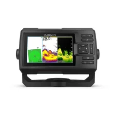
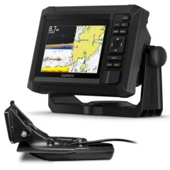
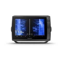
Garmin Striker Vivid 5cv is a sonar with GPS functionality. It allows you to track your routes and mark interesting places on the screen. Striker devices do not have an actual map base. However, they draw a depth chart map of the areas you are navigating and surveying with your boat. CV devices have an accurate ClearVü sonar that surveys directly downward from the boat. A transom sensor is included.
- Screen size: 5'
- Button-operated
- Includes GT20 transducer
- GPS - draws tracks and depth curves
- Dimensions 18.8 x 11.6 x 5.4cm
- Button-operated
- Screen size 6.5 x 10.8cm
- Screen resolution 800 x 480 pixels
- No map
Garmin ECHOMAP Ultra 2 102sv – 10" chartplotter and sonar for demanding fishing
The Garmin ECHOMAP Ultra 2 102sv is a powerful 10-inch chartplotter and sonar for active fishing. It combines a bright touchscreen, high-resolution sonar image, and extensive mapping and networking features in a compact size.
Bright 10” touchscreen
The large 10-inch touchscreen is easy to read even in direct sunlight. The fast interface and clear view make navigation and fishing effortless.
GT56UHD-TM transom mount transducer included
All the tools for successful fishing. ECHOMAP Ultra 2 chartplotters are designed for anglers who want to see more and react faster. The ECHOMAP Ultra 2 102sv comes with a GT56 sonar transducer , which provides:
- Traditional Garmin CHIRP sonar
- ClearVü™ scanning sonar
- SideVü™ scanning sonar
You can see the bottom structures, vegetation and fish in great detail, almost photographically.
LiveScope™ sonar support
The device supports Garmin LiveScope™ sonar , which lets you see fish and structure in motion in real time (LiveScope transducers sold separately).
Accurate maps and navigation
Supports Garmin Navionics+™ and Garmin Navionics Vision+™ charts with:
- extensive inland and coastal coverage
- daily map updates
- Auto Guidance+™ technology
Wireless connections and smart features
- Wireless sharing of sonar, waypoints and routes
- Saving screenshots
- ActiveCaptain® mobile app (updates, Quickdraw™ charts)
Multi-band GPS
Multi-band GNSS improves positioning accuracy in challenging environments.
Wide compatibility
- NMEA 2000®
- Fusion Link™
- Garmin Force® trolling motor
Bright and accurate colors
The bright and high-contrast color palettes of the UHD scanning sonar make it easy to identify targets, structures and fish, even in challenging conditions.
Top-notch map support
The device supports Garmin Navionics+™ and Garmin Navionics Vision+™ charts , which provide:
- extensive coastal and inland water coverage
- daily map updates
- Auto Guidance+™ technology for route planning
Wireless connections and data sharing
If you have another compatible ECHOMAP Ultra 2 or ECHOMAP UHD2 chartplotter on your boat, you can share sonar, waypoints, and routes wirelessly .
Saving screenshots allows you to share fishing moments and document your own fishing stories.
Precise positioning with multi-band GPS
Multi-band GNSS improves location accuracy, especially in areas where signals are weak or reflected.
Extensive network and accessory connections
ECHOMAP Ultra 2 is NMEA 2000® compatible , so you can connect to:
- direction and motion sensors
- autopilot
- Fusion-Link™ audio systems
ActiveCaptain® app
By pairing your chartplotter with the ActiveCaptain® mobile app, you get access to:
- software updates
- screen recording
- Garmin Quickdraw™ Community Maps
Compatible with Force® trolling motor
Wireless connection to a Garmin Force® trolling motor allows you to navigate to waypoints, plot routes and track them directly from your chartplotter.
Easy to remove and transport
The included quick-release mounting bracket makes installing and removing the device quick and easy.
In the package:
- ECHOMAP Ultra 102sv
- GT56UHD-TM sonar transducer
- Power cord
- Mounting bracket and quick-release bracket
- Sunshade
- Hardware
- Guides
- Display: 10"
- Touchscreen: Yes
- Dimensions: 29.5 x 19.5 x 9.8 cm
- Weight: 1.8 kg
- Waterproof rating: IPX7
- Display type: WXGA, IPS
- Screen size (W x H): 21.7 x 13.6 cm
- Screen resolution: 1280 x 800 px
- Operation: Touch screen and buttons
- Mounting: Pedestal or flush mounting
Maps and memory
- Memory card slots: 2 x microSD
- Waypoints: 5,000
- Posting points: 50,000
- Saved tracks: 50
- Routes: 100
Positioning and sensors
- Satellite systems: GPS, GLONASS, Galileo, BeiDou
- Internal receiver: Yes
- Receiver: 10 Hz
- Multi-band GNSS: Yes
- WAAS support: Yes
- NMEA 2000®: Yes
- NMEA 0183: No
Map support
- No preinstalled maps
- Internal Auto Guidance+: No
- Garmin Navionics+™ compatible
- Garmin Navionics Vision+™ compatible
- BlueChart® g3 compatible
- BlueChart® g3 Vision compatible
- TOPO 100K compatible
- Standard maps
- Garmin Quickdraw Contours™
Chartplotter functions
- AIS compatible: Yes
- DSC compatible: Yes
- ActiveCaptain® compatible: Yes
- FUSION-Link™ support: Yes
- Sailing features: Yes
Electrical information
- Power supply: 9–18 Vdc
- Typical current consumption (12 V): 2.3 A
- Maximum current consumption (12 V): 5 A
- Maximum power: 34 W
Sonar – technical features
- Sonar power: 600 W
- Traditional sonar:
- Internal single-channel CHIRP
- Frequencies: 70 / 83 / 200 kHz (Low, Medium, High CHIRP)
- ClearVü™: 260 / 455 / 800 / 1000 / 1200 kHz
- SideVü™: 260 / 455 / 800 / 1000 / 1200 kHz
- Panoptix™ compatible: Yes
- LiveScope™ compatible: Yes
Connections and connections
- NMEA 2000® ports: 1
- Garmin Marine Network™: 2 ports (large connector)
- Transducer connection: 12-pin scanning sonar
- Wi-Fi®: Yes
- ANT®: Yes
- Bluetooth®: No
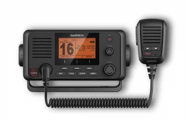
Garmin VHF 215i AIS marine radio
Features
- Displays AIS (Automatic Identification System) targets on the chartplotter
- Class D DSC (Digital Selective Calling) function (distress calls and direct calls using user-programmed MMSI number)
- In emergency situations, DSC may improve the chances of a quick rescue
- 25 watts of transmit power and internal GPS
- Pre-programmed international boating channels
In the package:
- VHF 215i AIS marine radio
- Detachable handheld microphone
- Handheld microphone mounting stand and accessories
- Rack, knobs and mounting hardware
- Protective cover
- Frame
- Flush mounting gasket
- Power cord
- Guides
- Device dimensions (H x W x D): 9.8 x 19.7 x 14.9 cm
- Weight: radio without microphone 1.2 kg, microphone 0.25 kg
- Water rating: IPX7
- Temperatures: operating -15–70°C, storage -20–70°C
- Compass safety distance: 75 cm
- NMEA 2000: yes
- NMEA 0183: yes
- DSC (Digital Selective Calling): class D
- Frequency bands: all international maritime channels
- Operating voltage: 12.0 Vdc
- Power consumption: standby 350 mA, receiving 600 mA, transmitting 2.0-6.0 A (1-25 W)
- Frequency range: 156.050 MHz–163.275 MHz (including WX channels)
- Megaphone output power: 20 W / 4 ?
- Megaphone impedance: 4 ?
- External speaker impedance: 4?
- Antenna connection: S0-239 (50 ?)
- Maximum antenna gain: 9 dBi

6" touchscreen and three different sonar options
With sharp, clear traditional sonar and bright ClearVü and SideVü scanning sonar, fish can’t escape. Plus, ECHOMAP UHD2 supports LiveScope™ real-time scanning sonar. The bright, clear colors of scanning sonar make it easy to distinguish targets and structure. The ECHOMAP UHD2 supports a wide range of Garmin transducers.
Experience unprecedented coverage and detail with optional Garmin Navionics+ charts or optional Garmin Navionics Vision Premium charts, featuring features like accurate elevation shading, satellite and sonar imagery, and includes a 1-year subscription of downloadable daily updates.
If you have another compatible ECHOMAP UHD2 chartplotter on your boat, you can wirelessly share data like sonar1, waypoints and routes with it.
Connect to the free, comprehensive mobile app via built-in Wi-Fi® for features like OneChart™, smart notifications, software updates, and Garmin QuickDraw community insights2.
Chartplotters with built-in Garmin Navionics+ charts include Auto Guidance+ technology3, which is available for download using the ActiveCaptain app.
The ECHOMAP UHD2 chartplotter can connect wirelessly to a Force trolling motor for things like creating and following routes, navigating to waypoints, controlling speed, checking battery life, and more. Multi-band GPS gives you even more accurate positioning, especially in areas with reflected or weak signals.
Specifications
- Dimensions: 20.6 x 13.1 x 6.7 cm
- Touchscreen: Yes
- Button operation: Touch screen and button operation
- Screen size: LXK: 13.8 x 7.8 cm, 15.7 cm
- Screen resolution: LXK: 800 x 480 pixels
- Display type: WVGA, TN
- Weight: 0.8 kg
- Water rating: IPX7
- Mounting options: Mounting or recessed
- Supports memory cards: 1 microSD™ card; size up to 32 GB
- Waypoints: 5,000
- Posting points: 50,000
- Tracks: 50 saved tracks
- Routes: 100
- Internal GPS receiver: Yes
- AIS compatible: Yes
- DSC compatible: Yes
- Supports FUSION-LINK™ compatible radios: Kyylä
- ActiveCaptain compatible: Yes
- Sailing features: Yes
Included in the package:
- ECHOMAP UHD2 display
- 12-pin sonar to 8-pin transducer adapter cable
- Power cord
- Tilt/swivel stand with quick-release dock
- Protective cover
- Hardware
- Guides
- Screen size: 6"
- Touchscreen and buttons
- Sonar must be purchased separately
- Three types of sonar: Garmin traditional sonar, ClearVü™ and SideVü™ sonar.
- Improved details and separated targets on sonar.
- If you use another ECHOMAP UHD2 chartplotter, you can share sonar, waypoints, and routes wirelessly.


