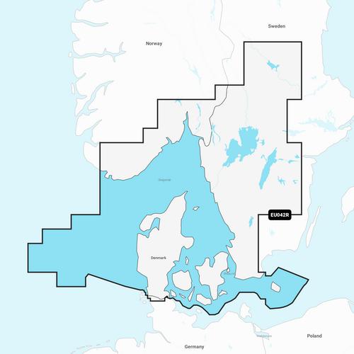
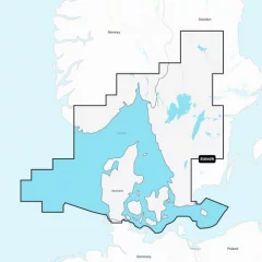
Garmin Navionics+ NSEU042R Chart, Oslo–Trelleborg

Garmin Navionics+ charts provide highly detailed mapping of coastal areas, lakes, rivers and other bodies of water. The charts include shaded depth contours to help you navigate shallow water and find the best fishing spots. With new advanced Auto Guidance technology, you get the best guidance, as Garmin and Navionics routing functions are now integrated. Daily updates are available through the ActiveCaptain® app, so you always have the most up-to-date chart information.
Garmin Navionics+ NSEU042R
Detailed information from the Norwegian and Swedish coasts from Flekkefjord (Norway) to Ystad (Sweden) and the entire Danish coast. The information covers Limfjorden, Kattegat, the Sound of Yttersund (Öresund), Læsø, Bornholm and Swedish lakes such as Vänern, Vättern, Fryken, Siljan, Mjörn, Sommen, Nommen and Bolmen. Ports included include Oslo and Kristiansand (Norway), Copenhagen and Aarhus (Denmark) and Gothenburg and Malmö (Sweden).
You can access the map material here .
Check map compatibility here or with customer service.
New integrated content
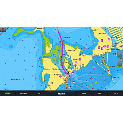
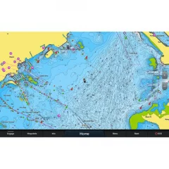
Integrated content from Garmin and Navionics for marine and lake areas, with an updated color palette in the style of Navionics, offering excellent coverage, clarity and detail.
Daily updates
One year of free updates is included, and map updates are available daily through the ActiveCaptain app. After one year, you retain full map functionality, including Auto Guidance+, and can purchase additional updates via subscription if desired.
Auto guidance+ technology
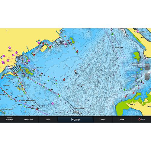
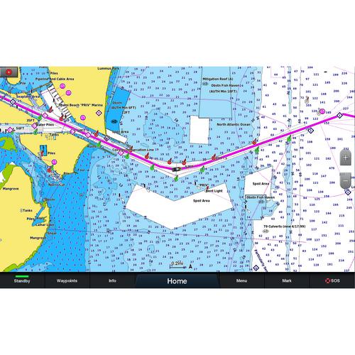
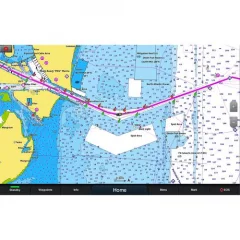
Combining Garmin and Navionics automatic routing capabilities, built-in Auto Guidance technology provides the smoothest route from start to finish, including through channels and inlets.
Shaded curves
Shaded depth range, choose from 10 different color shadings.
Curves up to 0.5m apart
Improved for fishing and navigation, curves up to 0.5 meters provide a more detailed view of the bottom structure.
Shading on navigation maps
To make navigation easier, you can adjust the depth curves to suit you best.
Active captain community
ActiveCaptain community where you can make recommendations and get advice from other boaters on everything from guest ports to port services
Tuotenr: 14404
Valmistajan tuotenr: 010-C1245-20
Garmin Navionics+ charts provide highly detailed mapping of coastal areas, lakes, rivers and other bodies of water. The charts include shaded depth contours to help you navigate shallow water and find the best fishing spots. With new advanced Auto Guidance technology, you get the best guidance, as Garmin and Navionics routing functions are now integrated. Daily updates are available through the ActiveCaptain® app, so you always have the most up-to-date chart information.
Garmin Navionics+ NSEU042R
Detailed information from the Norwegian and Swedish coasts from Flekkefjord (Norway) to Ystad (Sweden) and the entire Danish coast. The information covers Limfjorden, Kattegat, the Sound of Yttersund (Öresund), Læsø, Bornholm and Swedish lakes such as Vänern, Vättern, Fryken, Siljan, Mjörn, Sommen, Nommen and Bolmen. Ports included include Oslo and Kristiansand (Norway), Copenhagen and Aarhus (Denmark) and Gothenburg and Malmö (Sweden).
You can access the map material here .
Check map compatibility here or with customer service.
New integrated content
Integrated content from Garmin and Navionics for marine and lake areas, with an updated color palette in the style of Navionics, offering excellent coverage, clarity and detail.
Daily updates
One year of free updates is included, and map updates are available daily through the ActiveCaptain app. After one year, you retain full map functionality, including Auto Guidance+, and can purchase additional updates via subscription if desired.
Auto guidance+ technology
Combining Garmin and Navionics automatic routing capabilities, built-in Auto Guidance technology provides the smoothest route from start to finish, including through channels and inlets.
Shaded curves
Shaded depth range, choose from 10 different color shadings.
Curves up to 0.5m apart
Improved for fishing and navigation, curves up to 0.5 meters provide a more detailed view of the bottom structure.
Shading on navigation maps
To make navigation easier, you can adjust the depth curves to suit you best.
Active captain community
ActiveCaptain community where you can make recommendations and get advice from other boaters on everything from guest ports to port services
Tuotenr: 14404
Valmistajan tuotenr: 010-C1245-20
Suosittelemme sinulle


