Garmin Navionics Vision+ NVEU078R Chart, Oslo, Skagerrak and Haugesund
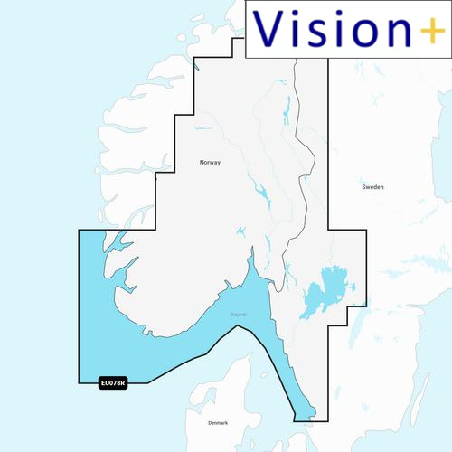


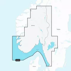
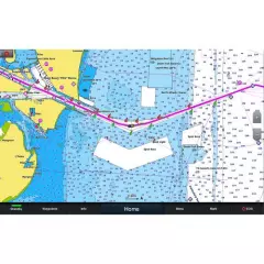
Garmin Navionics Vision+ NVEU078R
Detailed information on the Norwegian and Swedish coast from Haugesund to Halmstad, including the Boknafjorden, Oslofjorden and the Skagerrak area. Also included are inland waters — including lakes Mjøsa, Bandak, Kviteseidvatnet, Flåvatn, Norsjø and Heddalsvatnet, and canals such as the Telemark Canal. Ports and destinations include Stavanger and Oslo (Norway), as well as Gothenburg (Sweden).
You can access the map material here .
Check map compatibility here or with customer service.
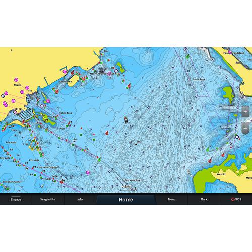
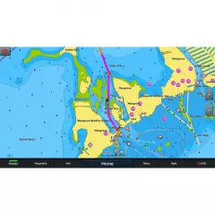
Vision+ additional features
Relief shading — better representation of the shape of the seabed and coastline, not just curves.
High-resolution satellite and aerial imagery of coastal areas and terrain — makes it easier to identify landmarks, ports, bridges, and other objects.
3D views: including 3D “fish-eye / marinereye” projection of underwater depths, where you can see the shapes of the bottom realistically.
Aerial photos / aerial photos of ports & port surroundings — makes it easier to land and visualize ports: harbors, piers, bridges, etc.
Ease of use and clearer visual appearance — colors, shading, and different view layers make reading the map more intuitive.
New integrated content
Integrated content from Garmin and Navionics for marine and lake areas, with an updated color palette in the style of Navionics, offering excellent coverage, clarity and detail.
Daily updates
One year of free updates is included, and map updates are available daily through the ActiveCaptain app. After one year, you retain full map functionality, including Auto Guidance+, and can purchase additional updates via subscription if desired.
Auto guidance+ technology
Combining Garmin and Navionics automatic routing capabilities, built-in Auto Guidance technology provides the smoothest route from start to finish, including through channels and inlets.
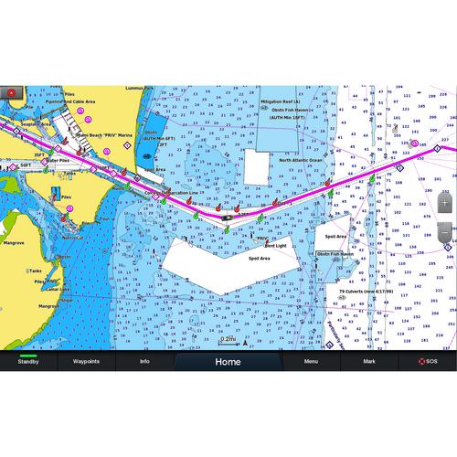
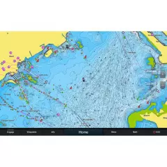
Shaded curves
Shaded depth range, choose from 10 different color shadings.
Curves up to 0.5m apart
Improved for fishing and navigation, curves up to 0.5 meters provide a more detailed view of the bottom structure.
Shading on navigation maps
To make navigation easier, you can adjust the depth curves to suit you best.
Active captain community
ActiveCaptain community where you can make recommendations and get advice from other boaters on everything from guest ports to port services
Tuotenr: 010-C1244-00
Garmin Navionics Vision+ NVEU078R
Detailed information on the Norwegian and Swedish coast from Haugesund to Halmstad, including the Boknafjorden, Oslofjorden and the Skagerrak area. Also included are inland waters — including lakes Mjøsa, Bandak, Kviteseidvatnet, Flåvatn, Norsjø and Heddalsvatnet, and canals such as the Telemark Canal. Ports and destinations include Stavanger and Oslo (Norway), as well as Gothenburg (Sweden).
You can access the map material here .
Check map compatibility here or with customer service.
Vision+ additional features
Relief shading — better representation of the shape of the seabed and coastline, not just curves.
High-resolution satellite and aerial imagery of coastal areas and terrain — makes it easier to identify landmarks, ports, bridges, and other objects.
3D views: including 3D “fish-eye / marinereye” projection of underwater depths, where you can see the shapes of the bottom realistically.
Aerial photos / aerial photos of ports & port surroundings — makes it easier to land and visualize ports: harbors, piers, bridges, etc.
Ease of use and clearer visual appearance — colors, shading, and different view layers make reading the map more intuitive.
New integrated content
Integrated content from Garmin and Navionics for marine and lake areas, with an updated color palette in the style of Navionics, offering excellent coverage, clarity and detail.
Daily updates
One year of free updates is included, and map updates are available daily through the ActiveCaptain app. After one year, you retain full map functionality, including Auto Guidance+, and can purchase additional updates via subscription if desired.
Auto guidance+ technology
Combining Garmin and Navionics automatic routing capabilities, built-in Auto Guidance technology provides the smoothest route from start to finish, including through channels and inlets.
Shaded curves
Shaded depth range, choose from 10 different color shadings.
Curves up to 0.5m apart
Improved for fishing and navigation, curves up to 0.5 meters provide a more detailed view of the bottom structure.
Shading on navigation maps
To make navigation easier, you can adjust the depth curves to suit you best.
Active captain community
ActiveCaptain community where you can make recommendations and get advice from other boaters on everything from guest ports to port services
Tuotenr: 010-C1244-00
Suosittelemme sinulle


