Harbour Guide 8: Arholma - Landsort

- 4 edition
- Swedish-speaking
- The most comprehensive and best port guide to the Stockholm archipelago
A very comprehensive and well-illustrated harbor guide to the Stockholm archipelago
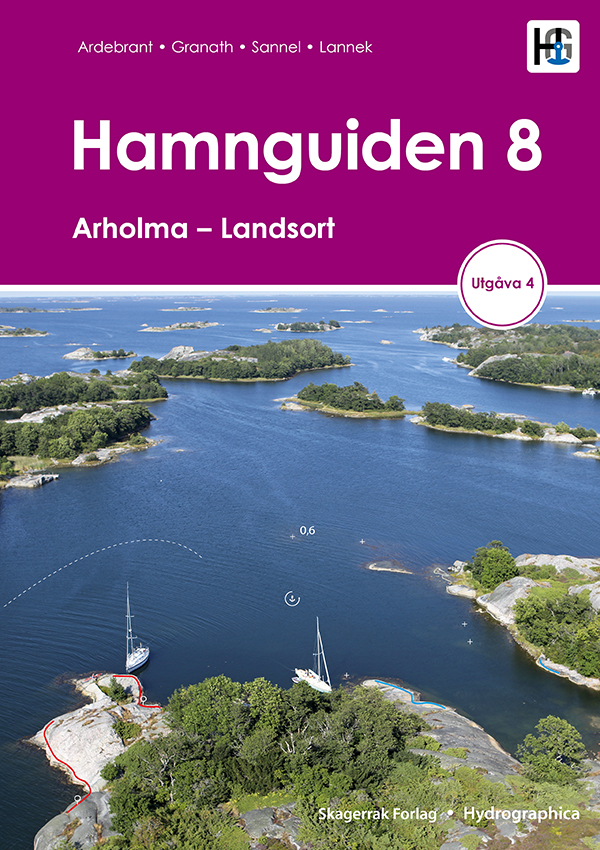
Includes over 400 natural and guest harbors from Arholma to Landsort. Each harbor is presented with a detailed harbor map, helicopter photo and harbor information.
The map data is unique. Each map is produced by Hydrographica, which means that the map data is produced from 3D aerial photographs and verified with on-site measurements. Helicopter images provide an overview of the ports, their surroundings, facilities, inlets, hazards and mooring opportunities. Notable shoals and rocks are marked on the images.
In addition to sea and waterway charts, Hamnguid's books include advanced topographic maps of the areas, based on laser scanning to measure contours and create a 3D image of the area using shading. These help assess where it is best to anchor, whether the islands are open and sensitive to wind.
Tuotenr: 88146
- 4 edition
- Swedish-speaking
- The most comprehensive and best port guide to the Stockholm archipelago
A very comprehensive and well-illustrated harbor guide to the Stockholm archipelago
Includes over 400 natural and guest harbors from Arholma to Landsort. Each harbor is presented with a detailed harbor map, helicopter photo and harbor information.
The map data is unique. Each map is produced by Hydrographica, which means that the map data is produced from 3D aerial photographs and verified with on-site measurements. Helicopter images provide an overview of the ports, their surroundings, facilities, inlets, hazards and mooring opportunities. Notable shoals and rocks are marked on the images.
In addition to sea and waterway charts, Hamnguid's books include advanced topographic maps of the areas, based on laser scanning to measure contours and create a 3D image of the area using shading. These help assess where it is best to anchor, whether the islands are open and sensitive to wind.
Tuotenr: 88146
Suosittelemme sinulle


