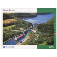
Inland Water Chart Series S, Saimaa Canal (2000)

- Map series S
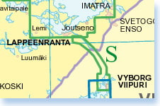
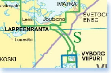
- Area Saimaa Canal
- Scale: 1:10,000
- Size: 59 × 42 cm
- Number of pages: 22
- Appearance/binding: wire-bound
- Series: Inland Water Chart Series
- Library class: 69.6302
- ISBN : 978-952-266-224-8
- EAN : 9789522662248
- ID: F203661
- Publisher: Karttakeskus
- Language: Finnish, English, German
- Year of publication: 2000
The Finnish Transport Agency's lake area nautical chart series are intended for all types of boating. In addition to the normal map pages, the chart series contain a large number of special charts that facilitate navigation in certain difficult-to-navigate areas. The chart series are spiral-bound atlases, and they are packed in a plastic pocket. The coordinate system of the atlas is KKJ , and the map is colored green. The inland water nautical chart series are divided regionally as follows:
- J Vesijärvi–Päijänne 1:40,000
- K Keitele and Keitele's canal 1:40,000
- L Lappeenranta–Savonlinna 1:40,000
- M Savonlinna–Kuopio 1:40,000
- N Tampere–Currents 1:30,000
- O Tampere–Hämeenlinna 1:30,000
- P Valkeakoski–Längelmäki–Hauho 1:30,000
- R Pielisjoki 1:20,000
- S Saimaa Canal 1:10,000
- T Oulujärvi 1:40 000
- V Savonlinna–Joensuu 1:40,000
Tuotenr: FBS
- Map series S
- Area Saimaa Canal
- Scale: 1:10,000
- Size: 59 × 42 cm
- Number of pages: 22
- Appearance/binding: wire-bound
- Series: Inland Water Chart Series
- Library class: 69.6302
- ISBN : 978-952-266-224-8
- EAN : 9789522662248
- ID: F203661
- Publisher: Karttakeskus
- Language: Finnish, English, German
- Year of publication: 2000
The Finnish Transport Agency's lake area nautical chart series are intended for all types of boating. In addition to the normal map pages, the chart series contain a large number of special charts that facilitate navigation in certain difficult-to-navigate areas. The chart series are spiral-bound atlases, and they are packed in a plastic pocket. The coordinate system of the atlas is KKJ , and the map is colored green. The inland water nautical chart series are divided regionally as follows:
- J Vesijärvi–Päijänne 1:40,000
- K Keitele and Keitele's canal 1:40,000
- L Lappeenranta–Savonlinna 1:40,000
- M Savonlinna–Kuopio 1:40,000
- N Tampere–Currents 1:30,000
- O Tampere–Hämeenlinna 1:30,000
- P Valkeakoski–Längelmäki–Hauho 1:30,000
- R Pielisjoki 1:20,000
- S Saimaa Canal 1:10,000
- T Oulujärvi 1:40 000
- V Savonlinna–Joensuu 1:40,000
Tuotenr: FBS
Suosittelemme sinulle


