International Map Series
Map series from the coasts of the Baltic Sea countries.International Map Series -ryhmän tuotteet
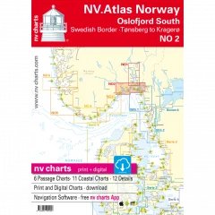
The NV Charts atlas NO2 covers the southern part of the Oslofjord. The NV Charts charts for the Norwegian coast are based on data from the Norwegian Hydrographic Office and also include the Norske Los harbour plans and numerous specially mapped details. The clear structure helps you quickly find approaches, harbours and anchorages, and important navigational information, which is also visible in the NV Charts app, is highlighted. Tide information is available both in tables and as a paper chart. The chart series impresses with its optimal dimensions and balanced sheet layout.
Area overview
The NO2 nautical chart takes you from the Swedish border straight to the bustling Oslofjord and all the way to historic Fredrikstad. From there, you can cross the fjord to Tønsberg and continue along the beautiful coast to the popular Kragerø. Of course, you can also use the detailed charts to sail the Telemark Canal or visit one of the many islands.
Order the NO1 map series if you want to visit Norway's modern capital. If you're heading towards the Skagerrak, we recommend the NO3 series, which takes you all the way to the shipping town of Kristiansand. For the Telemark Canal, we offer official Norwegian maps that are printed individually.
This map set includes:
- 6 general maps
- 11 regional maps
- 12 detailed maps
- Digital charts for navigation software and NV Charts (356-day license)
- Navigation instructions in English and Norwegian
- Port plans in paper and digital format
- Series 2 1 : 520,000
- S 15 Mecklenburger Bucht West 1 : 155,000
- S 15A Mecklenburger Bucht Ost 1 : 155,000
- S 16 Møn Southeast 1 : 155,000
- S 23 Sund Süd 1 : 140,000
- S 24 Møn - Rügen - Ystad 1 : 230,000
- S 24A Ystad - Rügen - Bornholm 1 : 230,000
- S 25 Bornholm 1 : 140,000
- S 25A Hanö Bay 1 : 260,000
- S 13 Fehmarn 1 : 80,000
- S 14 Lübecker Bucht 1 : 80,000
- S 17 Smålandsfahrwasser West 1 : 80,000
- S 18 Smålandsfahrwasser Ost 1 : 82,000
- S 19 Grönsund 1 : 60,000
- S 19A Guldborg Sund 1: 60,000
- S 20 Fax Book 1 : 60,000
- S 21 Sund Mitte 1 : 80,000
- S 13A Fehmarnsund 1 : 30,000
- S 14A Wismar Bay 1 : 42,000
- S 19 Vordingborg 1 : 25,000
- S 19A Nykøbing 1 : 30,000
- S 22 Copenhagen 1 : 35,000
- S 25 Christiansø 1 : 12,000
- S 25B Die Travemündung 1 : 10,000
- S 25C Untertrave 1 : 16,500
- S 25D Häfen von Rostock 1 : 20,000
- S 25D Warnemünde 1 : 10,000
- 2023
- Series 4 1:370,000
- S 25 Bornholm 1 : 140,000
- S 45 Hiddensee to Swinemünde 1 : 250,000
- S 46 Rügen to Bornholm 1 : 230,000
- S 36 The Bodden south of Zingst 1 : 60,000
- S 37 Strelasund North 1: 60,000
- S 38 Hiddensee to Jasmund 1 : 60,000
- S 39 Strelasund South 1: 40,000
- S 39A Stralsund 1 : 40,000
- S 40 Greifswalder Bodden West 1 : 60,000
- S 41 Greifswalder Bodden East 1 : 60,000
- S 42 Peenestrom South 1: 60,000
- S 43 Stettiner Haff 1 : 80,000
- S 43A Dievenow 1 : 60,000
- S 44 The Oder to Stettin-North 1 : 30,000
- S 44A The Oder to Stettin-South 1 : 30,000
- S 45A Arkona to Landtief 1 : 100,000
- S 25 Christiansø 1 : 12,000
- S 36 Am Bock 1 : 25,000
- S 39A Vitter Bodden 1: 30,000
- S 39A Ports of Stralsund 1 : 12,000
- S 41A Ruden to Wolgast 1 : 40,000
- S 42 Zecherin 1 : 40,000
- S 43A Dievenow Control 1 : 10,000
- S 43A Swinemünde 1 : 40,000
- -2023
- Kiel Bay
- Bornholm
- Sound, Kattegat
- Szczecin, Rund Ruen
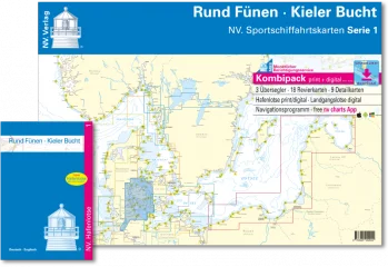
- Pilot chart series 1 1 : 750,000
- S 1 Kiel Bay West 1 : 150,000
- S 1A Kiel Bay East 1 : 150,000
- S 2 Kiel Fjord 1 : 40,000
- S 3 Kiel Bay South-West 1 : 80,000
- S 4 Flensburg Fjord 1 : 80,000
- S 5 Little Belt South 1 : 80,000
- S 6 Little Belt Central 1 : 80,000
- S 7 Little Belt North 1 : 80,000
- S 8 North Funen 1 : 80,000
- S 9 Great Belt North 1 : 80,000
- S 10 Great Belt Central 1 : 80,000
- S 11 Great Belt South 1 : 80,000
- S 12 South Funen 1 : 80,000
- Schlei 1 + 2 1 : 35,000
- Kiel Canal 1 + 2 (4 maps) 1:55,000
- S 4A Inner Flensburg Fjord 1 : 35,000
- S 6A Alssund & Augustenborgfjord 1: 25,000
- S 7A Snævringen & Kolding Fjord 1: 40,000
- S 8B Odense & Haderslev Fjord 1: 35,000, 1: 42,000
- S 10A Controls Great Belt Bridge 1 : 30,000
- S 12A Svendborg Sund 1: 18,000
- S 12B controls Fåborg / Rudkøbing Løb & Marstal 1: 33,000
- S 12C Nakskov Fjord & Inner Eckernförde Bay 1: 30,000
- 2023
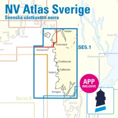
- S1 Halden to Lysekil 1: 240,000
- S2 Lysekil to Varberg 1: 240,000 (Pilot Chart Anholt-Færder-Jomfruland 1: 750,000 only in digital format)
- S3 Krokstrand to Svinesund 1: 40,000
- S3A Åbyfjorden to Brofjorden 1: 40,000
- S4 Svinesund to Dynekilen 1: 40,000
- S5 Dynekilen to Koster Fjord 1: 40,000 S6 Koster Fjord to Havstenssund 1: 40,000
- S7 Havstenssund to Bramskär 1: 40,000
- S8 Bramskär to Hamburgsund 1: 40,000
- S9 Hamburgsund to Smögen 1: 40,000
- S10 Smögen to Fiskebäckskil 1: 40,000
- S11 Gullmarn Fjord 1: 40,000
- S12 Koster Archipelago 1: 20,000
- S13 Grebbestad to Fjällbacka 1: 20,000
- S14 Fjällbacka to Dannemark 1: 20,000
- S15 Denmark to Sotekanal 1: 20,000
- S16 Smögen to Malmö 1: 20,000
- S17 Malmö to Lysekil 1: 20,000
- West Coast – North
- Port information
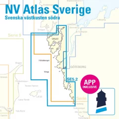
- S1 Halden to Lysekil 1: 240,000
- S2 Lysekil to Varberg 1: 240,000, (Pilot Chart Anholt-Færder-Jomfruland 1: 750,000 only in digital format)
- S3 North of Orust 1: 40,000
- S4 East of Orust 1: 40,000
- S5 North of Tjörn 1: 40,000
- S6 East of Tjörn 1: 40,000,
- S7 Fiskebäckskil to Käringön 1: 40,000
- S8 Käringön to Marstrand 1: 40,000
- S9 Marstrand to Sälö 1: 40,000
- S10 Sälö to Öckerö 1: 40,000
- S11 Öckerö to Vinga 1: 40,000
- S12 Vinga to Tistlarna 1: 40,000
- S13 Thistles to Malö 1: 40,000
- S14 Malö to Ringhals 1: 40,000
- S15 Ringhals to Varberg 1: 40,000
- S16A Northern River 1: 40,000
- S16C Kungsbackafjord 1: 40,000
- S3A Råbergsund 1: 10,000
- S16B Nordre Älv Flood barrage 1: 3,000
- S17 Lysekil to Gullholmen 1: 20,000
- S18 Gullholmen to Käringö Fjord 1: 20,000
- S19 Käringö Fjord to Kyrkesund 1: 20,000
- S20 Kyrkesund to Klädesholmen 1: 20,000
- S21 Marstrand 1: 20,000
- S22 Öckerö to Vinga 1: 20,000
- S23 Långedrag to Vrångö 1: 20,000
- West Coast – South
- Port and anchorage information
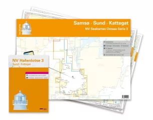
Saksalaisen NV Verlagin karttasarja from the Samsø-Sund-Kattegat area. 2023 Painos. Merikarttsarja contains the following karttasivut.
Series 3 1 : 520,000
Skagerrak 1:520,000
S 30 Kattegat Südwest 1 : 200,000
S 30A Kattegat Südost 1 : 200,000
S 31 Kattegat Mitte West 1 : 200,000
S 31A Kattegat Mitte Ost 1 : 200,000
S 32 Kattegat North 1 : 180,000
S 26 Sund North 1 : 80,000
S 27 Isefjord 1 : 65,000
S 27A Roskilde Fjord North 1 : 42,000
S 27B Roskilde Fjord South 1 : 42,000
S 28 Samsø Belt 1 :108,000
S 29 Aarhus Bay 1 :100,000
S 34 Randers & Mariager Fjord 1 : 56,000
S 35 Sund Nordansteuerung 1 : 65,000
S 26 Helsingør 1 : 25,000
S 27B Gershøj Selsø Control 1 : 25,000
S 33 Ansteuerung Frederikshavn 1 : 40,000
S 33 Frederikshavn 1 : 20,000
S 33 Ansteuerung Hals 1 : 45,000
S 34 Udbyhøj 1 : 18,000
S 34 Hadsund Brücke 1 : 16,000
S 35 Hallands Väderö 1 : 40,000
-2023


