Tuoteryhmät
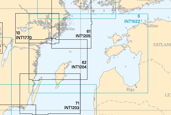
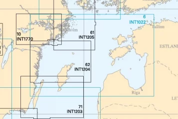
Nautical Chart of Sweden 6, Baltic Sea North (2022)
- Scale: 1 : 500000
Swedish Sjöfartsverket general map of the North Baltic Sea. The map is limited to the Hankoniemi-Utö line in the north, covers the entire Gulf of Riga in the east, borders the middle of Öland in the south and the east coast of Sweden in the west.
See a more detailed map demarcation on the Finnish Maritime Administration's virtual Se på Sjökort service. by clicking here
See a more detailed map demarcation on the Finnish Maritime Administration's virtual Se på Sjökort service. by clicking here
Tuotenr: SS0006
Valmistajan tuotenr: INT 1022
34,90 €
Yhteensä sis. alv 25.5%
Helsinki LauttasaariNot currently availablehyllypaikka: Varasto
Vantaa PorttipuistoNot currently available
VerkkokauppaMore arriving soondelivery time 29.07.2026 d
Toimituksen hinta: 5,90 €Matkahuolto's Near Parcel
Lisävarusteet
- Scale: 1 : 500000
Swedish Sjöfartsverket general map of the North Baltic Sea. The map is limited to the Hankoniemi-Utö line in the north, covers the entire Gulf of Riga in the east, borders the middle of Öland in the south and the east coast of Sweden in the west.
See a more detailed map demarcation on the Finnish Maritime Administration's virtual Se på Sjökort service. by clicking here
See a more detailed map demarcation on the Finnish Maritime Administration's virtual Se på Sjökort service. by clicking here
Tuotenr: SS0006
Valmistajan tuotenr: INT 1022
Suosittelemme sinulle
Maksutavat


