Maps and Books - All offers!
Maps and Books - All offers! -ryhmän tuotteet
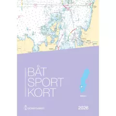
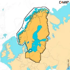
Swedish map series Vänern.
- Spiral bound A3
- Printed on water-repellent Pretex paper.
- Information in Finnish and English
- 137 ports covering the entire Åland archipelago
- 25 guest harbours and 112 excursion or natural harbours
- Clear images, texts and service listings
- Detailed map drawing and high-quality aerial photography of each port
- Depth data and curves based on own soundings
- A renewed look
- Extensive approach maps for areas near natural harbors
- Search maps, stories and narratives
- 204 spiral-bound, A4-sized pages
C-MAP DISCOVER X offers a completely new, dynamic charting experience. You have access to the latest vector data, state-of-the-art day and night modes and the most accurate C-MAP High-Res Bathymetry basemap. Newly introduced is the Map Inspector tool, which displays the most important information quickly and clearly. DISCOVER X integrates seamlessly with the Simrad Companion App. Versatile features such as customizable depth shading, tide and current information, subscription-free autorouting and 12 months of free online updates make navigation easier and safer.
Next Generation Charts
A next-generation mapping experience that makes navigation clearer than ever.
Optimized map data and a new presentation method provide the best possible overview on the water.
You always see the information you need without unnecessary clutter, at all zoom levels.
Excellent day and night modes ensure easy and safe use in all weather conditions, regardless of the time of day.
Smooth App Integration
Seamless integration with the Simrad Companion App.
You can plan routes, view journeys, and create waypoints in the app and sync them directly to your NSX device.
You can also access NSX device guides, instructions, and other materials directly from the app.
The future is connected navigation, and C-MAP and Simrad keep you ready for it.
The Best of C-MAP
The latest map data provides everything you need to navigate the water.
High-quality vector maps are based on official hydrographic data and make navigation accurate and reliable.
High-Res Bathymetry shows shallows, ledges, mounds and other bottom features with up to 1 foot accuracy.
Subscription-free autorouting automatically calculates the shortest and safest route based on map data and boat settings.
Customizable depth shading helps highlight desired depths and makes fishing even more efficient.
Detailed port and approach information brings confidence when entering new ports and waterways.
New Map Inspector Tool
The new Map Inspector feature displays the information you need quickly and with one tap.
Tide and current information makes it easier to plan your day.
Accurate port maps include floor plans, berth locations, restricted areas and other important information for thousands of ports.
Includes 12 months of free map updates.
Key features:
Next Generation Charts
Smooth App Integration
Map Inspector Tool
Large vector maps
High-Res Bathymetry
Customizable depth shading
State-of-the-art day and night modes
Tide and current information
Detailed port maps
Approach and port information
Subscription-free autorouting
12 months of free updates
Ready for the connected future
- Finland, Sweden, Norway and the Baltic Sea
- Compatible only with Simrad NSX, NSS 4 and B&G Zeus S, SR series devices
- MicroSD card 16GB (SD adapter included)
- Free map updates for 12 months
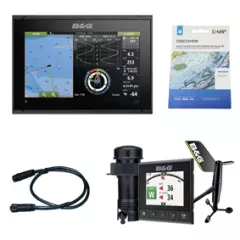
B&G Vulcan 9 FS navigation package with WS310 wind sensor – a complete package for the sailor
This carefully crafted navigation package offers everything you need for modern, accurate boating – especially for sailors who want reliable data and ease of use in one package. The package combines B&G’s top-of-the-line chartplotter, wireless wind measurement, sonar and comprehensive map data. It also includes the necessary NMEA 2000 cable for easy setup.
Package contents:
- B&G Vulcan 9 FS Chartplotter
- Powerful and easy-to-use 9” multifunction display with touch control, built-in WiFi and support for sailing-optimized functions.
B&G Triton² Wired Log, Echosounder and WS310 Wind Package. An accurate and reliable measurement system that includes speed and depth sensors and the modern WS310 wireless wind sensor. An excellent choice for the sailor who wants real-time and accurate data. - Simrad / Lowrance NMEA 2000 cable (1.8 m). Allows easy and reliable connection of devices to the same network.
- C-MAP Discover Y055 chart (Finland, Sweden, Norway and the Baltic Sea). Extensive and detailed chart data covering the coastal areas of the Nordic countries and the Baltic Sea - perfect for navigation on both domestic waters and longer trips.
Why choose this package?
- Complete package – all compatible components together
- Designed specifically for sailing
- Accurate wind, speed and depth data
- Easy installation and expandability (NMEA 2000)
- Extensive map coverage for the Nordic countries
If your boat does not have a pre-built NMEA2000 network, you can easily build one with this kit (optional): Lowrance/ Simrad NMEA2000 Starter kit
This package is an excellent choice for both the active enthusiast and the demanding sailor who wants a reliable and modern navigation system in one purchase.
- Complete plug & play package
- Designed for the sailor
- Easy-to-use Vulcan 9 FS chartplotter
- Wired WS310 wind sensor
- DST-810 depth/speed/temperature sensor, plastic
- Extensive map coverage of the Nordic countries
The nautical chart series published by the Finnish Transport Agency (traficom) are suitable for archipelago and coastal navigation due to their scale and accuracy. The nautical chart series shows, among other things, the locations of fairways and signs, underwater reefs and cables, and depth information. The nautical chart series is a spiral-bound chart sheet packed in a plastic pocket.
The chart sheets of the nautical chart series have been supplemented with detailed special charts to ensure safe boating near ports and narrows. The scale of the chart series is 1:50,000 (1 cm on the map = 500 m). The coordinate system of the charts is EUREF-FIN (WGS 84).
Depths on Finnish nautical charts are indicated in meters. In marine areas, depths are indicated according to the N2000 standard, and in inland waters, according to a level marked separately on each chart, which usually corresponds to the low water level of the water area in question.
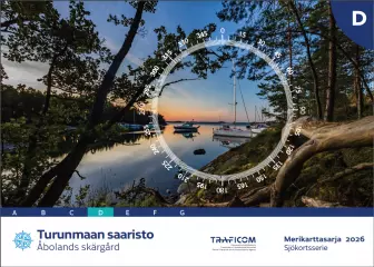
- Area: Turunmaa archipelago
- Release year: 2026
- Scale: 1:50,000
- Size: 46 × 34 cm
- Type: series
- Publisher: Traficom
- Languages: FI, SE, EN
NEW 2025 EDITION! Extensive new oceanographic surveys have been carried out in the sea area. The new chart series also feature a new nautical chart symbol, 'area of ??difficult navigation'. The black dotted line warns of very rocky areas where navigation requires special caution.
The new chart series excludes chart sheets 714, 730–733, which cover the Kihti area. The N2000 update has not yet progressed to the area and the missing sheets will be published in conjunction with the D series, which is expected to be completed for the 2026 sailing season.
The nautical chart series published by the Finnish Transport Agency (traficom) are suitable for archipelago and coastal navigation due to their scale and accuracy. The nautical chart series shows, among other things, the locations of fairways and signs, underwater reefs and cables, and depth information. The nautical chart series is a spiral-bound chart sheet packed in a plastic pocket.
The chart sheets of the nautical chart series have been supplemented with detailed special charts to ensure safe boating near ports and narrows. The scale of the chart series is 1:50,000 (1 cm on the map = 500 m). The coordinate system of the charts is EUREF-FIN (WGS 84)
Depths on Finnish nautical charts are indicated in meters. In marine areas, depths are indicated from mean water level, and in inland waters from a level marked separately on each chart, which usually corresponds to the low water level of the water area in question.
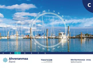
- Region: Åland Islands
- Release year: 2025
- Corrected: 30.4.2024
- Scale: 1:50,000
- Size: 46 × 34 cm
- Type: series
- Publisher: Traficom
- Languages: FI, SE, EN
Whether you’re out on the water for pleasure boating, fishing or sailing, C-MAP DISCOVER offers a wide range of coverage and all the essential features to help you make the most of your time on the water. DISCOVER includes C-MAP’s most accurate High-Res Bathymetry basemap, including Genesis data. It also includes rich vector maps, customizable depth shading, tide and current information, and free Easy Routing. Purchase includes 12 months of free online updates.
Compatible with Lowrance, Simrad and B&G chartplotters.
Features:
Versatile vector maps
Clear and up-to-date map navigation based on observed data produced by official hydrographic offices.
High-Res Bathymetry
A high-resolution basemap layer helps identify shallows, ridges, mounds, and ridges. Also included is a single layer of quality-assured Genesis data.
Customizable depth shading
Set a clear safety depth, keep the view like a paper map, or create shading that suits your needs.
Easy Routing
Automatic routing calculates the shortest and safest route based on map data and boat settings. No subscription required.
Tide and current information
View water level and current forecasts to help you plan your day, whether you're cruising, fishing, or sailing.
Detailed port maps
Easy and safe landing at the new port. The maps include detailed port floor plans, berth locations, restricted areas and other essential navigation information.
Accurate entry and approach information
Exceptionally detailed presentation brings confidence when approaching ports and fairways. The perfect finishing touch to a long journey, sailing trip or fishing day.
Online updates
Keep your maps up to date with 12 months of free online updates.
Compatible device series:
B&G
Vulcan series
Zeus 2
Zeus 3
Zeus 3S
Simrad
Cruise
GO
NSS Evo2
NSS Evo3
NSS Evo3S
NSO Evo2
NSO Evo3
NSO Evo3S
Lowrance
Hook Reveal
Hook 2
Eagle
Elite FS
Elite Ti / Ti2
HDS Carbon
HDS Gen2
HDS Gen3
HDS Live
HDS Pro
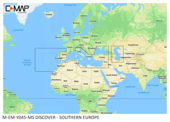
- Southern Europe
- Compatible with B&G, Simrad and Lowrance (see below for exact models)
- MicroSD card 4GB (SD adapter included)
- Includes free Genesis Live custom map recording feature on supported devices.
- Free map updates for 12 months
Whether you’re out on the water for pleasure boating, fishing or sailing, C-MAP DISCOVER offers a wide range of coverage and all the essential features to help you make the most of your time on the water. DISCOVER includes C-MAP’s most accurate High-Res Bathymetry basemap, including Genesis data. It also includes rich vector maps, customizable depth shading, tide and current information, and free Easy Routing. Purchase includes 12 months of free online updates.
Compatible with Lowrance, Simrad and B&G chartplotters.
Features:
Versatile vector maps
Clear and up-to-date map navigation based on observed data produced by official hydrographic offices.
High-Res Bathymetry
A high-resolution basemap layer helps identify shallows, ridges, mounds, and ridges. Also included is a single layer of quality-assured Genesis data.
Customizable depth shading
Set a clear safety depth, keep the view like a paper map, or create shading that suits your needs.
Easy Routing
Automatic routing calculates the shortest and safest route based on map data and boat settings. No subscription required.
Tide and current information
View water level and current forecasts to help you plan your day, whether you're cruising, fishing, or sailing.
Detailed port maps
Easy and safe landing at the new port. The maps include detailed port floor plans, berth locations, restricted areas and other essential navigation information.
Accurate entry and approach information
Exceptionally detailed presentation brings confidence when approaching ports and fairways. The perfect finishing touch to a long journey, sailing trip or fishing day.
Online updates
Keep your maps up to date with 12 months of free online updates.
Compatible device series:
B&G
Vulcan series
Zeus 2
Zeus 3
Zeus 3S
Simrad
Cruise
GO
NSS Evo2
NSS Evo3
NSS Evo3S
NSO Evo2
NSO Evo3
NSO Evo3S
Lowrance
Hook Reveal
Hook 2
Eagle
Elite FS
Elite Ti / Ti2
HDS Carbon
HDS Gen2
HDS Gen3
HDS Live
HDS Pro
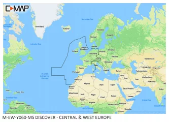
- Central and Western Europe continental region
- Compatible with B&G, Simrad and Lowrance (see below for exact models)
- MicroSD card 8GB (SD adapter included)
- Includes free Genesis Live custom map recording feature on supported devices.
- Free map updates for 12 months
Whether you’re out on the water for pleasure boating, fishing or sailing, C-MAP DISCOVER offers a wide range of coverage and all the essential features to help you make the most of your time on the water. DISCOVER includes C-MAP’s most accurate High-Res Bathymetry basemap, including Genesis data. It also includes rich vector maps, customizable depth shading, tide and current information, and free Easy Routing. Purchase includes 12 months of free online updates.
Compatible with Lowrance, Simrad and B&G chartplotters.
Features:
Versatile vector maps
Clear and up-to-date map navigation based on observed data produced by official hydrographic offices.
High-Res Bathymetry
A high-resolution basemap layer helps identify shallows, ridges, mounds, and ridges. Also included is a single layer of quality-assured Genesis data.
Customizable depth shading
Set a clear safety depth, keep the view like a paper map, or create shading that suits your needs.
Easy Routing
Automatic routing calculates the shortest and safest route based on map data and boat settings. No subscription required.
Tide and current information
View water level and current forecasts to help you plan your day, whether you're cruising, fishing, or sailing.
Detailed port maps
Easy and safe landing at the new port. The maps include detailed port floor plans, berth locations, restricted areas and other essential navigation information.
Accurate entry and approach information
Exceptionally detailed presentation brings confidence when approaching ports and fairways. The perfect finishing touch to a long journey, sailing trip or fishing day.
Online updates
Keep your maps up to date with 12 months of free online updates.
Compatible device series:
B&G
Vulcan series
Zeus 2
Zeus 3
Zeus 3S
Simrad
Cruise
GO
NSS Evo2
NSS Evo3
NSS Evo3S
NSO Evo2
NSO Evo3
NSO Evo3S
Lowrance
Hook Reveal
Hook 2
Eagle
Elite FS
Elite Ti / Ti2
HDS Carbon
HDS Gen2
HDS Gen3
HDS Live
HDS Pro
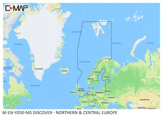
- Northern and Central European sea areas
- Compatible with B&G, Simrad and Lowrance (see below for exact models)
- MicroSD card 8GB (SD adapter included)
- Includes free Genesis Live custom map recording feature on supported devices.
- Free map updates for 12 months
C-MAP DISCOVER X offers a completely new, dynamic charting experience. You have access to the latest vector data, state-of-the-art day and night modes and the most accurate C-MAP High-Res Bathymetry basemap. Newly introduced is the Map Inspector tool, which displays the most important information quickly and clearly. DISCOVER X integrates seamlessly with the Simrad Companion App. Versatile features such as customizable depth shading, tide and current information, subscription-free autorouting and 12 months of free online updates make navigation easier and safer.
Next Generation Charts
A next-generation mapping experience that makes navigation clearer than ever.
Optimized map data and a new presentation method provide the best possible overview on the water.
You always see the information you need without unnecessary clutter, at all zoom levels.
Excellent day and night modes ensure easy and safe use in all weather conditions, regardless of the time of day.
Smooth App Integration
Seamless integration with the Simrad Companion App.
You can plan routes, view journeys, and create waypoints in the app and sync them directly to your NSX device.
You can also access NSX device guides, instructions, and other materials directly from the app.
The future is connected navigation, and C-MAP and Simrad keep you ready for it.
The Best of C-MAP
The latest map data provides everything you need to navigate the water.
High-quality vector maps are based on official hydrographic data and make navigation accurate and reliable.
High-Res Bathymetry shows shallows, ledges, mounds and other bottom features with up to 1 foot accuracy.
Subscription-free autorouting automatically calculates the shortest and safest route based on map data and boat settings.
Customizable depth shading helps highlight desired depths and makes fishing even more efficient.
Detailed port and approach information brings confidence when entering new ports and waterways.
New Map Inspector Tool
The new Map Inspector feature displays the information you need quickly and with one tap.
Tide and current information makes it easier to plan your day.
Accurate port maps include floor plans, berth locations, restricted areas and other important information for thousands of ports.
Includes 12 months of free map updates.
Key features:
Next Generation Charts
Smooth App Integration
Map Inspector Tool
Large vector maps
High-Res Bathymetry
Customizable depth shading
State-of-the-art day and night modes
Tide and current information
Detailed port maps
Approach and port information
Subscription-free autorouting
12 months of free updates
Ready for the connected future
- Finland, Sweden, Norway and the Baltic Sea
- Compatible only with Simrad NSX, NSS 4 and B&G Zeus S, SR series devices
- MicroSD card 16GB (SD adapter included)
- Free map updates for 12 months

The only port book with all the ports of Lake Finland. Total of 288 pages.
- Published annually since 1992
- Can be used for years on the boat and at home
- Included in every fourth cruise ship
- Extensive information package - 288 pages
Information package for everyone who moves on the lake!
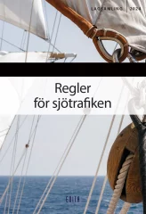
The Maritime Traffic Regulations collection contains all essential regulations, regulations that specify the legislation, the most important contact information needed in maritime traffic, and other useful information for boaters, such as a list of septic tank suction and emptying points.
The only book on the market that contains comprehensive maritime traffic regulations offers a comprehensive overview of legislation for everyone who moves on the sea. In addition to the Maritime Traffic Act, the book contains maritime traffic regulations and the regulations in the Maritime Act, the Criminal Code, the Water Act and the Fisheries Act that apply to maritime traffic. In addition, the collection contains several regulations from the Finnish Transport and Communications Agency Traficom, which specify the legislation.
Several statutes, including the Fisheries Act, have been amended from the previous year, which has been taken into account in the book.
- Edition: 2024
- Several statutes, including the Fisheries Act, have been amended from the previous year, which has been taken into account in the book.
- Language: Swedish
Integrated maps for a wide range of chartplotters
Navionics+ marine charts are a comprehensive solution that combines clear, reliable coastal/inland content with advanced guidance features, supporting a wide range of chartplotter brands.
Navionics chart data can be accessed in advance for free in the Navionics WebApp service.
Always ensure that the map card is compatible with your device before ordering.
Comprehensive mapping solution
Get detailed maps that include coastal features, lakes, and rivers, for a wide range of compatible chartplotters. Integrated coastal and inland lake content helps boaters worldwide.
Daily map updates
The charts are constantly updated with new and changed content. Thousands of updates are made every day. You also get a one-year subscription to get daily chart updates via the Navionics Chart Installer software.
Route guidance between ports
Advanced route guidance technology2 calculates route suggestions between ports based on boat settings, chart data and most frequently traveled routes.
Curves up to 0.5m apart
Making both fishing and navigation easier, the curves drawn at intervals of up to 0.5 meters clearly show the bottom shapes on fishing maps and in detail, for example in marshes, canals, harbors and marinas.
Advanced map settings
Community edits
Downloadable community edits provide useful local information in the Navionics Boating app and allow you to view the data on your compatible chartplotter.
Plotter synchronization
Real-time SonarChart™ maps
More Premium Features with Navionics Platinum+ Chart Solutions:
- Accurate shading
Downloadable shading5 shows the shapes of the base with colors and shadows, making it easier to interpret and clearer than just curved lines.
- Accurate satellite images
Downloadable high-resolution satellite imagery5 gives you a realistic view of your surroundings, which is especially handy when arriving in unfamiliar ports.
- Aerial photos
Ports, marinas, bridges, docks, boat ramps, dams and navigational landmarks are particularly clearly visible in aerial and surface imagery, improving situational awareness above the water surface.
- 3D view
Unique 3D views give you an additional perspective above and below the water surface to enhance situational awareness as key features are highlighted.
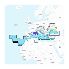
- Navionics Mediterranean and Black Sea NPEU643L
- Detailed information about the Mediterranean and Black Seas
- MicroSD card (32GB, SD adapter included)
- Includes the Mediterranean and Black Sea regions
- 1 year of free updates
- Route guidance
- Size 230x297mm
- Language : Finnish
- 48 pages
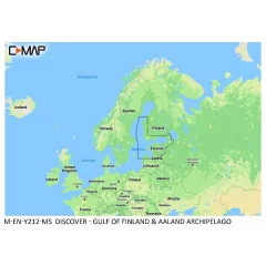
Whether you’re out on the water for pleasure boating, fishing or sailing, C-MAP DISCOVER offers a wide range of coverage and all the essential features to help you make the most of your time on the water. DISCOVER includes C-MAP’s most accurate High-Res Bathymetry basemap, including Genesis data. It also includes rich vector maps, customizable depth shading, tide and current information, and free Easy Routing. Purchase includes 12 months of free online updates.
Compatible with Lowrance, Simrad and B&G chartplotters.
Features:
Versatile vector maps
Clear and up-to-date map navigation based on observed data produced by official hydrographic offices.
High-Res Bathymetry
A high-resolution basemap layer helps identify shallows, ridges, mounds, and ridges. Also included is a single layer of quality-assured Genesis data.
Customizable depth shading
Set a clear safety depth, keep the view like a paper map, or create shading that suits your needs.
Easy Routing
Automatic routing calculates the shortest and safest route based on map data and boat settings. No subscription required.
Tide and current information
View water level and current forecasts to help you plan your day, whether you're cruising, fishing, or sailing.
Detailed port maps
Easy and safe landing at the new port. The maps include detailed port floor plans, berth locations, restricted areas and other essential navigation information.
Accurate entry and approach information
Exceptionally detailed presentation brings confidence when approaching ports and fairways. The perfect finishing touch to a long journey, sailing trip or fishing day.
Online updates
Keep your maps up to date with 12 months of free online updates.
Compatible device series:
B&G
Vulcan series
Zeus 2
Zeus 3
Zeus 3S
Simrad
Cruise
GO
NSS Evo2
NSS Evo3
NSS Evo3S
NSO Evo2
NSO Evo3
NSO Evo3S
Lowrance
Hook Reveal
Hook 2
Eagle
Elite FS
Elite Ti / Ti2
HDS Carbon
HDS Gen2
HDS Gen3
HDS Live
HDS Pro
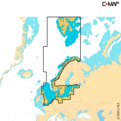
- Gulf of Finland and Åland Islands
- Compatible with B&G, Simrad and Lowrance (see below for exact models)
- MicroSD card (SD adapter included)
- Includes free Genesis Live custom map recording feature on supported devices.
- Free map updates for 12 months
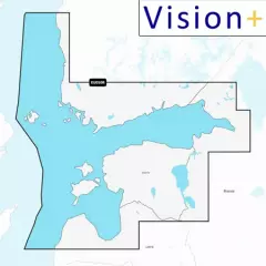
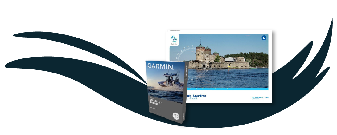
Garmin Navionics Vision+ NVEU050R
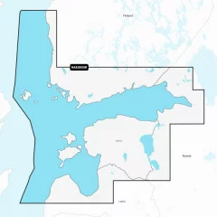
Vision+ map card. Detailed information on the Gulf of Finland from Åland to St. Petersburg (Russia), including the Gulf of Riga, Lake Peipsi and the Narva River. The information covers the ports of Turku, Helsinki and Kotka (Finland), Vyborg, Kronstadt and Lomonosov (Russia), Tallinn (Estonia) and Riga and Ventspils (Latvia).
You can access the map material here .
Check map compatibility here or with customer service.
Vision+ additional features
Relief shading — better representation of the shape of the seabed and coastline, not just curves.
High-resolution satellite and aerial imagery of coastal areas and terrain — makes it easier to identify landmarks, ports, bridges, and other objects.
3D views: including 3D “fish-eye / marinereye” projection of underwater depths, where you can see the shapes of the bottom realistically.
Aerial photos / aerial photos of ports & port surroundings — makes it easier to land and visualize ports: harbors, piers, bridges, etc.
Ease of use and clearer visual appearance — colors, shading, and different view layers make reading the map more intuitive.
Comprehensive mapping solution for Garmin chartplotters
Get detailed maps that include coastlines, lakes, rivers, and more. Integrated Garmin and Navionics content helps boaters worldwide.
Daily map updates
The maps are constantly updated with new and revised content, with up to 5,000 updates per day. With the included one-year subscription, you get daily map updates via the ActiveCaptain app on your smart devices.
Auto guidance+ technology
Built-in Auto Guidance+ technology2 combines the best of Garmin and Navionics automatic routing features to suggest a route between marinas, including through canals, straits and marina entrances.
Depth of field shading
With precise depth range shading, you can select up to 10 color shading options and view defined target depths at a glance.
Curves up to 0.5m apart
The curves, drawn at intervals of up to 0.5 meters, make both fishing and navigation easier, showing the bottom contours clearly and in detail, for example in marshes, canals, harbors and marinas.
Shallow water shading
This function allows the user to define the depth of shading and thus avoid shallow water areas.
Active captain community
Community-contributed content provides useful points of interest, such as marinas, anchorages, obstacles, and businesses. Get recommendations from people with first-hand experience of the local environment.
By far the most popular chart card for devices from Lowrance, Simrad, Raymarine and Humminbird, among others. The chart card is supplied in an SD adapter, which contains a smaller microSD card.
Navionics chart data can be accessed in advance for free in the Navionics WebApp service.
Always ensure that the map card is compatible with your device before ordering.
ATTENTION FOR LOWRANCE DEVICES! Works with Lowrance Elite HDI and Elite CHIRP series and all HDS series devices. Not compatible with older Lowrance devices that cannot use 16Gb memory cards.
- Navionics Finnish sea area MSD/EU050R
- Sea areas: Gulf of Finland and Riga
- MicroSD card (16GB, SD adapter included)
- All Navionics charts also include small boat lanes
- 12 months of free updates. Requires registration of the chart card in the Navionics online service within 2 months of chart purchase.
Garmin Navionics+ NSEU055R
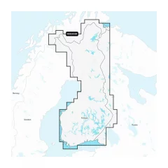
Detailed information on Finnish lakes, including Inarijärvi, Miekojärvi, Simojärvi and Kiantajärvi. Also includes detailed information on Oulujärvi, Pielinen, Saimaa, Päijänne, Näsijärvi, Lohjanjärvi, Nuorajärvi, Kilpisjärvi and other lakes.
Check map compatibility here or with customer service.
Comprehensive mapping solution for Garmin chartplotters
Daily map updates
Auto guidance+ technology
Depth of field shading
Curves up to 0.5m apart
Shallow water shading
Active captain community
EU050R chart card. Garmin Navionics+ charts feature vibrant colors, a streamlined interface, combined coastal/inland content, and the popular Navionics®-style color palette, allowing you to easily plan your route with the most popular marine chart provider on the market.
Garmin Navionics+ NSEU050R
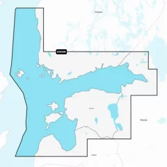
Detailed information on the Gulf of Finland from Åland to St. Petersburg (Russia), including the Gulf of Riga, Lake Peipsi and Narva River. The information covers the ports of Turku, Helsinki and Kotka (Finland), Vyborg, Kronstadt and Lomonosov (Russia), Tallinn (Estonia) and Riga and Ventspils (Latvia).
You can access the map material here .
Check map compatibility here or with customer service.


