Garmin Chart Cards
Garmin electronic map cards.Garmin Chart Cards -ryhmän tuotteet
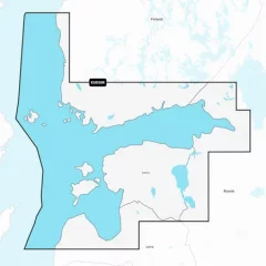
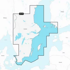
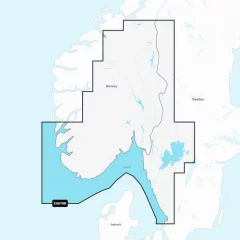
EU050R chart card. Garmin Navionics+ charts feature vibrant colors, a streamlined interface, combined coastal/inland content, and the popular Navionics®-style color palette, allowing you to easily plan your route with the most popular marine chart provider on the market.
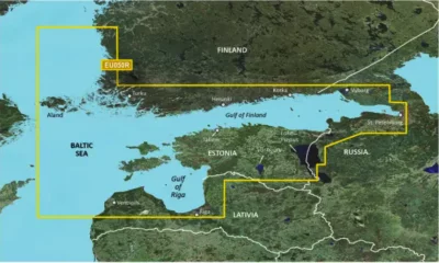
Garmin Navionics+ NSEU050R
Detailed information on the Gulf of Finland from Åland to St. Petersburg (Russia), including the Gulf of Riga, Lake Peipsi and Narva River. The information covers the ports of Turku, Helsinki and Kotka (Finland), Vyborg, Kronstadt and Lomonosov (Russia), Tallinn (Estonia) and Riga and Ventspils (Latvia).
You can access the map material here .
Check map compatibility here or with customer service.
Comprehensive mapping solution for Garmin chartplotters
Daily map updates
Auto guidance+ technology
Depth of field shading
Curves up to 0.5m apart
Shallow water shading
Active captain community
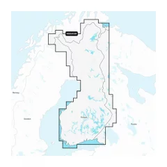
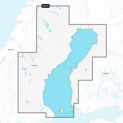
Garmin Navionics+ NSEU055R
Detailed information on Finnish lakes, including Inarijärvi, Miekojärvi, Simojärvi and Kiantajärvi. Also includes detailed information on Oulujärvi, Pielinen, Saimaa, Päijänne, Näsijärvi, Lohjanjärvi, Nuorajärvi, Kilpisjärvi and other lakes.
Check map compatibility here or with customer service.
Comprehensive mapping solution for Garmin chartplotters
Daily map updates
Auto guidance+ technology
Depth of field shading
Curves up to 0.5m apart
Shallow water shading
Active captain community
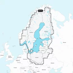
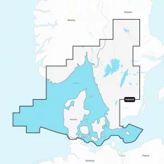
Chart Card NSEU644L. Garmin Navionics+ charts feature vibrant colors, a streamlined interface, and combined coastal/inland content, along with the popular Navionics®-style color palette. It lets you easily plan your route with the most popular marine chart provider on the market
Garmin Navionics+ NSEU644L
Detailed information on the Baltic Sea and the lakes of Scandinavia and Poland. The information covers the Gulf of Bothnia, the Gulf of Finland and the Gulf of Riga; the Masurian Lakes in Poland, Oderinhaffin, Lake Peipus; Mjøsa, Bandak and Norsjø in Norway; Vänern, Vättern, Siljan and Storavan in Sweden and Inarijärvi, Miekojärvi, Simojärvi and Kiantajärvi in ??Finland and many more. Includes the following ports: Oslo (Norway), Malmö and Stockholm (Sweden), Oulu and Helsinki (Finland), St. Petersburg and Kaliningrad (Russia) and Gdansk (Poland).
You can access the map material here .
Check map compatibility here or with customer service.
Comprehensive mapping solution for Garmin chartplotters
Daily map updates
Auto guidance+ technology
Depth of field shading
Curves up to 0.5m apart
Shallow water shading
Active captain community
Garmin Navionics+ charts provide highly detailed mapping of coastal areas, lakes, rivers and other bodies of water. The charts include shaded depth contours to help you navigate shallow water and find the best fishing spots. With new advanced Auto Guidance technology, you get the best guidance, as Garmin and Navionics routing functions are now integrated. Daily updates are available through the ActiveCaptain® app, so you always have the most up-to-date chart information.
Garmin Navionics+ NSEU079R
A comprehensive map of the coast and inland waters of southern and eastern Sweden. The map covers the coastal areas from Helsingborg to Sundsvall, including the west coast to Turku, and includes, among others, Trelleborg, Nyköping, Stockholm, Norrtälje, Karlsborg and the islands of Öland, Gotland and Åland. Also included are large lakes and inland waters such as Vänern, Vättern, Sommen, Siljan, Runn, Fryken and Helgasjön as well as the lower part of the Dalälven from Gysinge to Söderfors, the Göta Canal and the Strömsholms Canal (up to Smedjebacken).
You can access the map material here .
Check map compatibility here or with customer service.
New integrated content
Integrated content from Garmin and Navionics for marine and lake areas, with an updated color palette in the style of Navionics, offering excellent coverage, clarity and detail.
Daily updates
One year of free updates is included, and map updates are available daily through the ActiveCaptain app. After one year, you retain full map functionality, including Auto Guidance+, and can purchase additional updates via subscription if desired.
Auto guidance+ technology
Combining Garmin and Navionics automatic routing capabilities, built-in Auto Guidance technology provides the smoothest route from start to finish, including through channels and inlets.
Shaded curves
Shaded depth range, choose from 10 different color shadings.
Curves up to 0.5m apart
Improved for fishing and navigation, curves up to 0.5 meters provide a more detailed view of the bottom structure.
Shading on navigation maps
To make navigation easier, you can adjust the depth curves to suit you best.
Active captain community
ActiveCaptain community where you can make recommendations and get advice from other boaters on everything from guest ports to port services
Garmin Navionics+ charts provide highly detailed mapping of coastal areas, lakes, rivers and other bodies of water. The charts include shaded depth contours to help you navigate shallow water and find the best fishing spots. With new advanced Auto Guidance technology, you get the best guidance, as Garmin and Navionics routing functions are now integrated. Daily updates are available through the ActiveCaptain® app, so you always have the most up-to-date chart information.
Garmin Navionics+ NSEU047R
Detailed map information for the entire Gulf of Bothnia. The map covers the Finnish and Swedish coasts with their archipelagos from Flee to Tornio south to the Bothnian Sea, as well as a wide range of inland lakes and rivers in northern Finland and northern Sweden. These include Kemi, Oulu, Vaasa and Rauma, as well as Luleå, Umeå, Sundsvall and Härnösand on the Swedish side. The map also includes several inland waters, such as Tjeggelvas, Hornavan, Siljan and Storsjön.
You can access the map material here .
Check map compatibility here or with customer service.
New integrated content
Integrated content from Garmin and Navionics for marine and lake areas, with an updated color palette in the style of Navionics, offering excellent coverage, clarity and detail.
Daily updates
One year of free updates is included, and map updates are available daily through the ActiveCaptain app. After one year, you retain full map functionality, including Auto Guidance+, and can purchase additional updates via subscription if desired.
Auto guidance+ technology
Combining Garmin and Navionics automatic routing capabilities, built-in Auto Guidance technology provides the smoothest route from start to finish, including through channels and inlets.
Shaded curves
Shaded depth range, choose from 10 different color shadings.
Curves up to 0.5m apart
Improved for fishing and navigation, curves up to 0.5 meters provide a more detailed view of the bottom structure.
Shading on navigation maps
To make navigation easier, you can adjust the depth curves to suit you best.
Active captain community
ActiveCaptain community where you can make recommendations and get advice from other boaters on everything from guest ports to port services
Garmin Navionics+ charts provide highly detailed mapping of coastal areas, lakes, rivers and other bodies of water. The charts include shaded depth contours to help you navigate shallow water and find the best fishing spots. With new advanced Auto Guidance technology, you get the best guidance, as Garmin and Navionics routing functions are now integrated. Daily updates are available through the ActiveCaptain® app, so you always have the most up-to-date chart information.
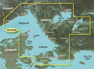
Garmin Navionics+ NSEU042R
Detailed information from the Norwegian and Swedish coasts from Flekkefjord (Norway) to Ystad (Sweden) and the entire Danish coast. The information covers Limfjorden, Kattegat, the Sound of Yttersund (Öresund), Læsø, Bornholm and Swedish lakes such as Vänern, Vättern, Fryken, Siljan, Mjörn, Sommen, Nommen and Bolmen. Ports included include Oslo and Kristiansand (Norway), Copenhagen and Aarhus (Denmark) and Gothenburg and Malmö (Sweden).
You can access the map material here .
Check map compatibility here or with customer service.
New integrated content
Integrated content from Garmin and Navionics for marine and lake areas, with an updated color palette in the style of Navionics, offering excellent coverage, clarity and detail.
Daily updates
One year of free updates is included, and map updates are available daily through the ActiveCaptain app. After one year, you retain full map functionality, including Auto Guidance+, and can purchase additional updates via subscription if desired.
Auto guidance+ technology
Combining Garmin and Navionics automatic routing capabilities, built-in Auto Guidance technology provides the smoothest route from start to finish, including through channels and inlets.
Shaded curves
Shaded depth range, choose from 10 different color shadings.
Curves up to 0.5m apart
Improved for fishing and navigation, curves up to 0.5 meters provide a more detailed view of the bottom structure.
Shading on navigation maps
To make navigation easier, you can adjust the depth curves to suit you best.
Active captain community
ActiveCaptain community where you can make recommendations and get advice from other boaters on everything from guest ports to port services
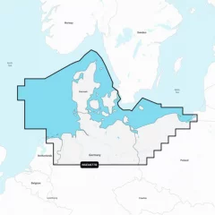
Chart Card EU077R. Garmin Navionics+ charts feature vibrant colors, a streamlined interface, combined coastal/inland content, and the popular Navionics®-style color palette, allowing you to easily plan your route with the most popular marine chart provider on the market.
Garmin Navionics+ NSEU077R
Detailed information on the North Sea and Baltic Sea coasts in Germany and Denmark. The information covers the Kiel Canal, Oderinhaff, Elbe, Kattegat and Bornholm as well as the ports of Hamburg (Germany) and Copenhagen (Denmark).
You can access the map material here .
Check map compatibility here or with customer service.
Comprehensive mapping solution for Garmin chartplotters
Get detailed maps that include coastlines, lakes, rivers, and more. Integrated Garmin and Navionics content helps boaters worldwide.
Daily map updates
The maps are constantly updated with new and changed content, with up to 5,000 updates per day. With the included one-year subscription, you get daily map updates via the ActiveCaptain app on your smart devices.
Auto guidance+ technology
Built-in Auto Guidance+ technology2 combines the best of Garmin and Navionics automatic routing features to suggest a route between marinas, including through canals, straits and marina entrances.
Depth of field shading
With precise depth range shading, you can select up to 10 color shading options and view defined target depths at a glance.
Curves up to 0.5m apart
The curves, drawn at intervals of up to 0.5 meters, make both fishing and navigation easier, showing the bottom contours clearly and in detail, for example in marshes, canals, harbors and marinas.
Shallow water shading
This function allows the user to define the depth of shading and thus avoid shallow water areas.
Active captain community
Community-contributed content provides useful points of interest, such as marinas, anchorages, obstacles, and businesses. Get recommendations from people with first-hand experience of the local environment.
Garmin Navionics+ NSEU078R
Detailed information on the Norwegian and Swedish coast from Haugesund to Halmstad, including the Boknafjorden, Oslofjorden and the Skagerrak area. Also included are inland waters — including lakes Mjøsa, Bandak, Kviteseidvatnet, Flåvatn, Norsjø and Heddalsvatnet, and canals such as the Telemark Canal. Ports and destinations include Stavanger and Oslo (Norway), as well as Gothenburg (Sweden).
You can access the map material here .
Check map compatibility here or with customer service.
Garmin Navionics+ – digital marine charts
Garmin Navionics+ provides comprehensive, up-to-date maps for coastal areas, lakes and other bodies of water. These maps make navigation clearer and safer. They include accurate depth contours, detailed updates and high-quality visuals to help you navigate the water with ease.
Safe and easy routing
Daily map updates
Clear depth perception
Accurate base maps
Community tips
Content and coverage
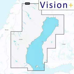
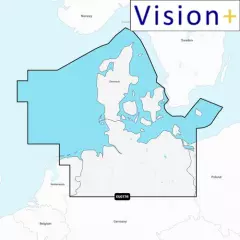
Garmin Navionics Vision+ NVEU050R
Vision+ map card. Detailed information on the Gulf of Finland from Åland to St. Petersburg (Russia), including the Gulf of Riga, Lake Peipsi and the Narva River. The information covers the ports of Turku, Helsinki and Kotka (Finland), Vyborg, Kronstadt and Lomonosov (Russia), Tallinn (Estonia) and Riga and Ventspils (Latvia).
You can access the map material here .
Check map compatibility here or with customer service.
Vision+ additional features
Relief shading — better representation of the shape of the seabed and coastline, not just curves.
High-resolution satellite and aerial imagery of coastal areas and terrain — makes it easier to identify landmarks, ports, bridges, and other objects.
3D views: including 3D “fish-eye / marinereye” projection of underwater depths, where you can see the shapes of the bottom realistically.
Aerial photos / aerial photos of ports & port surroundings — makes it easier to land and visualize ports: harbors, piers, bridges, etc.
Ease of use and clearer visual appearance — colors, shading, and different view layers make reading the map more intuitive.
Comprehensive mapping solution for Garmin chartplotters
Get detailed maps that include coastlines, lakes, rivers, and more. Integrated Garmin and Navionics content helps boaters worldwide.
Daily map updates
The maps are constantly updated with new and revised content, with up to 5,000 updates per day. With the included one-year subscription, you get daily map updates via the ActiveCaptain app on your smart devices.
Auto guidance+ technology
Built-in Auto Guidance+ technology2 combines the best of Garmin and Navionics automatic routing features to suggest a route between marinas, including through canals, straits and marina entrances.
Depth of field shading
With precise depth range shading, you can select up to 10 color shading options and view defined target depths at a glance.
Curves up to 0.5m apart
The curves, drawn at intervals of up to 0.5 meters, make both fishing and navigation easier, showing the bottom contours clearly and in detail, for example in marshes, canals, harbors and marinas.
Shallow water shading
This function allows the user to define the depth of shading and thus avoid shallow water areas.
Active captain community
Community-contributed content provides useful points of interest, such as marinas, anchorages, obstacles, and businesses. Get recommendations from people with first-hand experience of the local environment.
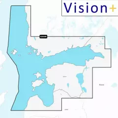
Garmin Navionics Vision+ NVEU055R
Detailed information on Finnish lakes, including Inarijärvi, Miekojärvi, Simojärvi and Kiantajärvi. Also includes detailed information on Oulujärvi, Pielinen, Saimaa, Päijänne, Näsijärvi, Lohjanjärvi, Nuorajärvi, Kilpisjärvi and other lakes.
You can access the map material here .
Check map compatibility here or with customer service.
Vision+ additional features
Relief shading — better representation of the shape of the seabed and coastline, not just curves.
High-resolution satellite and aerial imagery of coastal areas and terrain — makes it easier to identify landmarks, ports, bridges, and other objects.
3D views: including 3D “fish-eye / marinereye” projection of underwater depths, where you can see the shapes of the bottom realistically.
Aerial photos / aerial photos of ports & port surroundings — makes it easier to land and visualize ports: harbors, piers, bridges, etc.
Ease of use and clearer visual appearance — colors, shading, and different view layers make reading the map more intuitive.
Comprehensive mapping solution for Garmin chartplotters
Get detailed maps that include coastlines, lakes, rivers, and more. Integrated Garmin and Navionics content helps boaters worldwide.
Daily map updates
The maps are constantly updated with new and changed content, with up to 5,000 updates per day. With the included one-year subscription, you get daily map updates via the ActiveCaptain app on your smart devices.
Auto guidance+ technology
Built-in Auto Guidance+ technology2 combines the best of Garmin and Navionics automatic routing features to suggest a route between marinas, including through canals, straits and marina entrances. Depth of field shading
With precise depth range shading, you can select up to 10 color shading options and view defined target depths at a glance.Curves up to 0.5m apart
The curves, drawn at intervals of up to 0.5 meters, make both fishing and navigation easier, showing the bottom contours clearly and in detail, for example in marshes, canals, harbors and marinas.Shallow water shading
This function allows the user to define the depth of shading and thus avoid shallow water areas.Active captain community
Community-contributed content provides useful points of interest, such as marinas, anchorages, obstacles, and businesses. Get recommendations from people with first-hand experience of the local environment.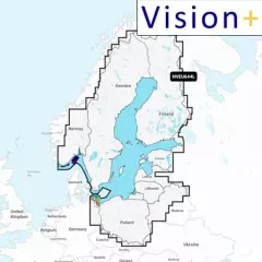
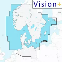
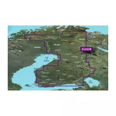
Garmin Navionics Vision+ NVEU644L
Detailed information on the Baltic Sea and the lakes of Scandinavia and Poland. The information covers the Gulf of Bothnia, the Gulf of Finland and the Gulf of Riga; the Masurian Lakes in Poland, Oderinhaffin, Lake Peipus; Mjøsa, Bandak and Norsjø in Norway; Vänern, Vättern, Siljan and Storavan in Sweden and Inarijärvi, Miekojärvi, Simojärvi and Kiantajärvi in ??Finland and many more. Includes the following ports: Oslo (Norway), Malmö and Stockholm (Sweden), Oulu and Helsinki (Finland), St. Petersburg and Kaliningrad (Russia) and Gdansk (Poland).
You can access the map material here .
Check map compatibility here or with customer service.
Vision+ additional features
Relief shading — better representation of the shape of the seabed and coastline, not just curves.
High-resolution satellite and aerial imagery of coastal areas and terrain — makes it easier to identify landmarks, ports, bridges, and other objects.
3D views: including 3D “fish-eye / marinereye” projection of underwater depths, where you can see the shapes of the bottom realistically.
Aerial photos / aerial photos of ports & port surroundings — makes it easier to land and visualize ports: harbors, piers, bridges, etc.
Ease of use and clearer visual appearance — colors, shading, and different view layers make reading the map more intuitive.
Comprehensive mapping solution for Garmin chartplotters
Get detailed maps that include coastlines, lakes, rivers, and more. Integrated Garmin and Navionics content helps boaters worldwide.
Daily map updates
The maps are constantly updated with new and changed content, with up to 5,000 updates per day. With the included one-year subscription, you get daily map updates via the ActiveCaptain app on your smart devices.
Auto guidance+ technology
Built-in Auto Guidance+ technology2 combines the best of Garmin and Navionics automatic routing features to suggest a route between marinas, including through canals, straits and marina entrances.
Depth of field shading
With precise depth range shading, you can select up to 10 color shading options and view defined target depths at a glance.
Curves up to 0.5m apart
The curves, drawn at intervals of up to 0.5 meters, make both fishing and navigation easier, showing the bottom contours clearly and in detail, for example in marshes, canals, harbors and marinas.
Shallow water shading
This function allows the user to define the depth of shading and thus avoid shallow water areas.
Active captain community
Community-contributed content provides useful points of interest, such as marinas, anchorages, obstacles, and businesses. Get recommendations from people with first-hand experience of the local environment.
Relief shading
Detailed shading3, which combines colors and shadows, shows the surface contours of the bottom more easily and clearly than simple curved lines.
Accurate satellite images
Downloadable high-resolution satellite imagery3 ensures excellent situational awareness.
Aerial photos
Ports, marinas, bridges, docks, boat ramps, dams and navigational landmarks are particularly clearly visible in aerial and surface imagery, improving situational awareness above the water surface.
3D Fisheye view
This underwater view shows the bottom and its contours in 3D from below the water surface. You can customize the view by adding sonar data.
3D Marine-eye view
In this view, the environment is shown in 3D from both above and below the water surface.
Lake level
In this view, the environment is shown in 3D from both above and below the water surface.
Garmin Navionics+ charts provide highly detailed mapping of coastal areas, lakes, rivers and other bodies of water. The charts include shaded depth contours to help you navigate shallow water and find the best fishing spots. With new advanced Auto Guidance technology, you get the best guidance, as Garmin and Navionics routing functions are now integrated. Daily updates are available through the ActiveCaptain® app, so you always have the most up-to-date chart information.
New integrated content
Integrated content from Garmin and Navionics for marine and lake areas, with an updated color palette in the style of Navionics, offering excellent coverage, clarity and detail.
Daily updates
One year of free updates is included, and map updates are available daily through the ActiveCaptain app. After one year, you retain full map functionality, including Auto Guidance+, and can purchase additional updates via subscription if desired.
Auto guidance+ technology
Combining Garmin and Navionics automatic routing capabilities, built-in Auto Guidance technology provides the smoothest route from start to finish, including through channels and inlets.
Shaded curves
Shaded depth range, choose from 10 different color shadings.
Curves up to 0.5m apart
Improved for fishing and navigation, curves up to 0.5 meters provide a more detailed view of the bottom structure.
Shading on navigation maps
To make navigation easier, you can adjust the depth curves to suit you best.
Active captain community
ActiveCaptain community where you can make recommendations and get advice from other boaters on everything from guest ports to port services
- Autorouting
- Daily map updates
- MICRO SD card
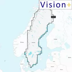
Garmin Navionics Vision+ NVEU645L
Comprehensive map of the Skagerrak and Kattegat region, including the coast from Kristiansund, Norway (Kristiansund, NO) to Gävle, Sweden (Gävle, SE), as well as Denmark and routes through the Kattegat. Also included are Åland, Turku (FI), Gotland and Bornholm Island, Szczecin Bay, the Kiel Canal and all of Denmark. Ports in the region: Oslo (NO), Malmö and Stockholm (SE), Copenhagen and Aarhus (DK), and Hamburg (DE). The map also covers inland waters – including Sweden's largest lakes (e.g. Vänern, Vättern, Mjörn, Sommen) and Norwegian inland lakes and canals (e.g. Mjøsa, Telemark Canal).
You can access the map material here .
Check map compatibility here or with customer service.
Vision+ additional features
Relief shading — better representation of the shape of the seabed and coastline, not just curves.
High-resolution satellite and aerial imagery of coastal areas and terrain — makes it easier to identify landmarks, ports, bridges, and other objects.
3D views: including 3D “fish-eye / marinereye” projection of underwater depths, where you can see the shapes of the bottom realistically.
Aerial photos / aerial photos of ports & port surroundings — makes it easier to land and visualize ports: harbors, piers, bridges, etc.
Ease of use and clearer visual appearance — colors, shading, and different view layers make reading the map more intuitive.
Garmin Navionics+ charts provide highly detailed mapping of coastal areas, lakes, rivers and other bodies of water. The charts include shaded depth contours to help you navigate shallow water and find the best fishing spots. With new advanced Auto Guidance technology, you get the best guidance, as Garmin and Navionics routing functions are now integrated. Daily updates are available through the ActiveCaptain® app, so you always have the most up-to-date chart information.
New integrated content
Integrated content from Garmin and Navionics for marine and lake areas, with an updated color palette in the style of Navionics, offering excellent coverage, clarity and detail.
Daily updates
One year of free updates is included, and map updates are available daily through the ActiveCaptain app. After one year, you retain full map functionality, including Auto Guidance+, and can purchase additional updates via subscription if desired.
Auto guidance+ technology
Combining Garmin and Navionics automatic routing capabilities, built-in Auto Guidance technology provides the smoothest route from start to finish, including through channels and inlets.
Shaded curves
Shaded depth range, choose from 10 different color shadings.
Curves up to 0.5m apart
Improved for fishing and navigation, curves up to 0.5 meters provide a more detailed view of the bottom structure.
Shading on navigation maps
To make navigation easier, you can adjust the depth curves to suit you best.
Active captain community
ActiveCaptain community where you can make recommendations and get advice from other boaters on everything from guest ports to port services
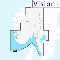
Garmin Navionics Vision+ NVEU078R
Detailed information on the Norwegian and Swedish coast from Haugesund to Halmstad, including the Boknafjorden, Oslofjorden and the Skagerrak area. Also included are inland waters — including lakes Mjøsa, Bandak, Kviteseidvatnet, Flåvatn, Norsjø and Heddalsvatnet, and canals such as the Telemark Canal. Ports and destinations include Stavanger and Oslo (Norway), as well as Gothenburg (Sweden).
You can access the map material here .
Check map compatibility here or with customer service.
Vision+ additional features
Relief shading — better representation of the shape of the seabed and coastline, not just curves.
High-resolution satellite and aerial imagery of coastal areas and terrain — makes it easier to identify landmarks, ports, bridges, and other objects.
3D views: including 3D “fish-eye / marinereye” projection of underwater depths, where you can see the shapes of the bottom realistically.
Aerial photos / aerial photos of ports & port surroundings — makes it easier to land and visualize ports: harbors, piers, bridges, etc.
Ease of use and clearer visual appearance — colors, shading, and different view layers make reading the map more intuitive.
New integrated content
Integrated content from Garmin and Navionics for marine and lake areas, with an updated color palette in the style of Navionics, offering excellent coverage, clarity and detail.
Daily updates
One year of free updates is included, and map updates are available daily through the ActiveCaptain app. After one year, you retain full map functionality, including Auto Guidance+, and can purchase additional updates via subscription if desired.
Auto guidance+ technology
Combining Garmin and Navionics automatic routing capabilities, built-in Auto Guidance technology provides the smoothest route from start to finish, including through channels and inlets.
Shaded curves
Shaded depth range, choose from 10 different color shadings.
Curves up to 0.5m apart
Improved for fishing and navigation, curves up to 0.5 meters provide a more detailed view of the bottom structure.
Shading on navigation maps
To make navigation easier, you can adjust the depth curves to suit you best.
Active captain community
ActiveCaptain community where you can make recommendations and get advice from other boaters on everything from guest ports to port services
Garmin Navionics Vision+ NVEU067R
A comprehensive map of Sweden's lakes, rivers and inland waters — including Vänern, Vättern, Mjörn, Sommen, Fryken, Siljan, Bolmen, Runn, Hornavan and Storsjön, as well as major canals and rivers such as the Göta, Hjälmare, Kinda, Södertälje, Säffle, Trollhätte and Dalsland canals and the Dalälven river from Borlänge to the Baltic Sea.
You can access the map material here .
Check map compatibility here or with customer service.
Vision+ additional features
Relief shading — better representation of the shape of the seabed and coastline, not just curves.
High-resolution satellite and aerial imagery of coastal areas and terrain — makes it easier to identify landmarks, ports, bridges, and other objects.
3D views: including 3D “fish-eye / marinereye” projection of underwater depths, where you can see the shapes of the bottom realistically.
Aerial photos / aerial photos of ports & port surroundings — makes it easier to land and visualize ports: harbors, piers, bridges, etc.
Ease of use and clearer visual appearance — colors, shading, and different view layers make reading the map more intuitive.
New integrated content
Integrated content from Garmin and Navionics for marine and lake areas, with an updated color palette in the style of Navionics, offering excellent coverage, clarity and detail.
Daily updates
One year of free updates is included, and map updates are available daily through the ActiveCaptain app. After one year, you retain full map functionality, including Auto Guidance+, and can purchase additional updates via subscription if desired.
Auto guidance+ technology
Combining Garmin and Navionics automatic routing capabilities, built-in Auto Guidance technology provides the smoothest route from start to finish, including through channels and inlets.
Shaded curves
Shaded depth range, choose from 10 different color shadings.
Curves up to 0.5m apart
Improved for fishing and navigation, curves up to 0.5 meters provide a more detailed view of the bottom structure.
Shading on navigation maps
To make navigation easier, you can adjust the depth curves to suit you best.
Active captain community
ActiveCaptain community where you can make recommendations and get advice from other boaters on everything from guest ports to port services
Garmin Navionics Vision+ NVEU077R
Detailed information on the German and Danish North Sea and Baltic Sea coasts. The map covers the Elbe region and Hamburg ports, the Kiel Canal, the Szczecin Lagoon and on the Danish side the ports of Kattegat, Bornholm and Copenhagen.
You can access the map material here .
Check map compatibility here or with customer service.
Vision+ additional features
Relief shading — better representation of the shape of the seabed and coastline, not just curves.
High-resolution satellite and aerial imagery of coastal areas and terrain — makes it easier to identify landmarks, ports, bridges, and other objects.
3D views: including 3D “fish-eye / marinereye” projection of underwater depths, where you can see the shapes of the bottom realistically.
Aerial photos / aerial photos of ports & port surroundings — makes it easier to land and visualize ports: harbors, piers, bridges, etc.
Ease of use and clearer visual appearance — colors, shading, and different view layers make reading the map more intuitive.
Garmin Navionics+ charts provide highly detailed mapping of coastal areas, lakes, rivers and other bodies of water. The charts include shaded depth contours to help you navigate shallow water and find the best fishing spots. With new advanced Auto Guidance technology, you get the best guidance, as Garmin and Navionics routing functions are now integrated. Daily updates are available through the ActiveCaptain® app, so you always have the most up-to-date chart information.
New integrated content
Integrated content from Garmin and Navionics for marine and lake areas, with an updated color palette in the style of Navionics, offering excellent coverage, clarity and detail.
Daily updates
One year of free updates is included, and map updates are available daily through the ActiveCaptain app. After one year, you retain full map functionality, including Auto Guidance+, and can purchase additional updates via subscription if desired.
Auto guidance+ technology
Combining Garmin and Navionics automatic routing capabilities, built-in Auto Guidance technology provides the smoothest route from start to finish, including through channels and inlets.
Shaded curves
Shaded depth range, choose from 10 different color shadings.
Curves up to 0.5m apart
Improved for fishing and navigation, curves up to 0.5 meters provide a more detailed view of the bottom structure.
Shading on navigation maps
To make navigation easier, you can adjust the depth curves to suit you best.
Active captain community
ActiveCaptain community where you can make recommendations and get advice from other boaters on everything from guest ports to port services
Garmin BlueChart g3 HXEU050R offers extremely comprehensive and detailed map data for the Gulf of Finland and Riga regions. The maps combine the best features of Garmin and Navionics, providing a clear and reliable navigation experience for boaters and fishermen alike.
The Auto Guidance feature makes route planning easier by calculating a suggested route based on your selected depth and altitude values. The route is displayed directly on the map, making navigation smooth even in challenging coastal conditions.
The chart card features accurate depth contours and bottom contours with an accuracy of up to 30 cm. This allows for a detailed view of shallows, channels, harbors and fishing areas. Depth range shading (up to 10 levels) and shallow water shading help you identify safe routes quickly and efficiently.
Additionally, the ActiveCaptain app allows you to download free NOAA raster charts, which provide a traditional paper-like view in compatible areas.
You can access the map material here .
Check map compatibility here or with customer service.
- Gulf of Finland and Gulf of Riga
- Area: HXEU050R
- Bluechart g3 are a previous generation Garmin chart, so they are also compatible with older Garmin devices
- Comprehensive and detailed map data of Finnish lakes
- Garmin and Navionics content combined
- Automatic guidance for route planning
- Depth of field shading (up to 10 levels)
- Shallow water shading for safer navigation
- Bottom contours with an accuracy of up to 30 cm
- Support for NOAA raster charts (with ActiveCaptain app)
BlueChart g3 offers unmatched coverage and crisp detail as you navigate the water. It features industry-leading coverage, sharpness, and detail with integration of Garmin and Navionics® content. Marine charts feature Auto Guidance, which calculates and suggests a route based on your desired depth and elevation that you can safely follow.
You can access the map material here .
Check map compatibility here or with customer service.
The charts contain ENC S57 standard nautical chart data provided by the Finnish Maritime Administration and Navionics. Searchable database of natural harbours from Hydrographica for the Stockholm archipelago and the West Coast.
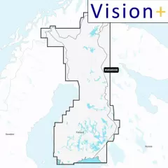
Garmin BlueChart g3 HXEU055R offers the most comprehensive and accurate maps of Finnish lake areas on the market. The maps combine Garmin and Navionics data, ensuring a clear, detailed and reliable navigation experience for boaters and fishermen alike.
The map card uses automatic guidance technology that calculates route suggestions based on the depth and underpass values ??you select. You can see the suggested route directly on the map, making route planning and navigation easier, especially in challenging waters.
BlueChart g3 charts feature accurate depth contours and contour lines with up to 12 in (30 cm) resolution. This provides excellent visibility of fishing grounds, canals, shallows, and marinas, among other areas. Plus, depth range shading (up to 10 levels) and shallow water shading help you quickly and clearly identify safe routes.
Through the ActiveCaptain app, you can download free NOAA raster charts that provide a traditional paper chart-like view in compatible areas.
- Finnish lakes
- Area: HXEU055R
- Comprehensive and detailed map data of Finnish lakes
- Garmin and Navionics content combined
- Automatic guidance for route planning
- Depth of field shading (up to 10 levels)
- Shallow water shading for safer navigation
- Bottom contours with an accuracy of up to 30 cm
- Support for NOAA raster charts (with ActiveCaptain app)
Note: Auto Guidance is intended for route planning purposes only and is not a substitute for safe navigation. This feature is not included with the BlueChart g3 charts preloaded on the ECHOMAP™ Plus series.


